Article of the Month - July 2025
|
GIS and the Geospatial Ecosystem: Creating the
World You Want to See
Linda Foster, PLS, GISP, United States

This article in .pdf-format
(8 pages)
Presentation
Linda Foster oversees Esri’s worldwide strategic vision for land
records, cadastre, surveying, and land administration. A leader in
professional organizations, she is currently president-elect of the
National Society of Professional Surveyors. Foster is a registered
land surveyor and certified GISP. She also holds a B.S. degree in
Geological Engineering and a Master’s degree in GIS from Penn State
University.
INTRODUCTION
I had the distinct honor of delivering a plenary keynote at the 2025
International Federation of Surveyors (FIG) Working Week in Brisbane,
Australia, which centered on two of my favorite topics –
GIS
and the geospatial ecosystem. I’m also a perpetual
problem-solver, so exploring how we can leverage these to
create the world we want to see
was a bonus. This article captures the essence of the keynote in
writing. I hope you all enjoy consuming it as much as I enjoyed
authoring it!
Our world is changing rapidly – both in positive ways, through
technology and innovation, and not-so-positive ways – our physical world
is in distress. More on this later.
But first, the innovation we’re experiencing can be seen and felt all
around us. Through agriculture, our urban environments,
transportation systems, energy, healthcare, communication, and
computing, we are really transforming how we live and improving our
quality of life in many ways.
Exploring the Geospatial Ecosystem
Much of this innovation can be found in the geospatial ecosystem –
enabling us to explore and solve problems in a way we could only once
imagine. But what exactly is the geospatial ecosystem? We hear so many
terms tossed around loosely – GIS, surveying, LiDAR, UAVs, remote
sensing, spatial data, and the like, all rolled into this concept of
“geospatial.”
Which is quite appropriate, because the definition of geospatial
according to the Merriam Webster Dictionary is “consisting of, derived
from, or relating to data that is directly linked to specific
geographical locations.” It also became apparent to me that we can
nicely represent this ecosystem from the word itself (Figure 1).
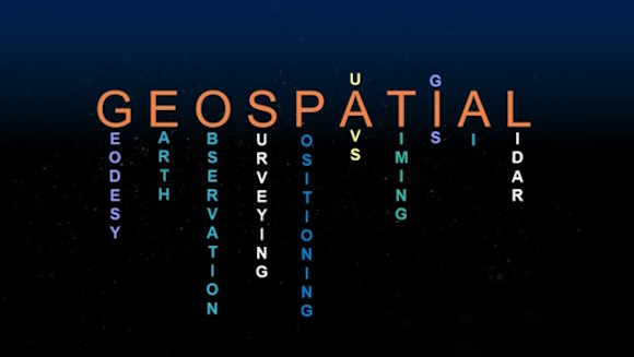
Figure 1. Word representation of the term “geospatial.”
Looking at everything included in Figure 1 can be overwhelming.
There’s a lot there, which means a lot to keep up with. Perhaps
Heraclitus said it best: “Change is the only constant in life.” I think
that if there were ever an example of this, geospatial would be a good
one.
To help put it all in better perspective, we’re going to step back in
time to examine how this geospatial ecosystem has come together, and
whether the change is really accelerating as quickly as it sometimes
feels.
Ancient Times – 1960
We have land surveying, which has deep historical
roots and is foundational to the development of our world, and remains
present throughout the decades ahead.
And, interestingly, some early origins of UAVs can
be traced back to 1849 – in the form of balloons, and by the early to
mid-1900s, radio-controlled aircraft.
How about GIS? Does the name Dr. John Snow sound familiar to
anyone? Although predating the term “GIS,” Dr.
Snow used the power of mapping and spatial analysis to identify the
source of a cholera outbreak in London.
As a side note, FIG was founded in 1878, and ISPRS in 1910.
Positioning and measurement are largely optical and
mechanical during this period.
1960-1970
Geographer Roger Tomlinson initiated a national land-use management
program for the Canadian government, which involved inventorying natural
resources. Tomlinson is credited with first coining the term geographic
information system (GIS).
It was also in 1969 that Esri was founded.
We are adding a new category during this decade, and that is
computing. This will be key as we continue moving through our
timeline. Throughout the 1960s, computers underwent significant
advancements in technology, speed, and design. Early concepts of
quantitative and computational geography begin to develop.
1970-1980
Although the decade between 1970 and 1980 appears to be a quiet one,
some substantial advancements were made – predominantly in
remote sensing and earth observation as well
as positioning.
In 1972, the first Landsat satellite was launched, and in 1978, the
first GPS satellite was launched.
Computing continues to advance during this period.
Fun fact – the word “geospatial” is also believed to
have emerged in 1970.
1980-1990
Again, a seemingly quiet decade, but don’t be fooled.
Notable progress to mention – in 1983, GPS became
available for civilian use, but the signals were scrambled.
In 1985, the first in-car (digital) navigation
system emerged, and computing advancements began to
accelerate.
A big one, for sure, was the invention of the World Wide Web
in 1989.
1990-2000
Although progress may seem anticlimactic over the course of this
decade, advancements in computing are significant.
Workstations and efficient data storage have emerged along with
websites for public use.
From a positioning standpoint, the first terrestrial Lidar
was introduced in 1998.
And, in 1999, we celebrated our first GIS day.
2000-2010
What happened during the 2000s?!? A lot!
In 2000, the U.S. government stopped scrambling the GPS signal,
making it accessible for innovation. Also, in the U.S., the FAA
began debating UAV use in its airspace.
The GIS community is also picking up speed, with over one million
users.
However, it was in the computing space that we really saw some
momentum. In 2004, Web 2.0 was introduced, emphasizing user-generated
content and ease of use.
And, in rapid succession, the following occurred: in 2005, Google
Maps emerged; in 2006, AWS introduced cloud computing; in 2007, Apple
released the first iPhone; and in 2009, Uber entered the scene.
Disruption.
Let’s pause for a moment – I think we can officially label what is
happening here as technological disruption.
Disruption, defined as “radical change to an existing industry or
market due to innovation,” is what we witnessed beginning in the early
2000s. A number of components in the geospatial ecosystem, as we
know it today, began to mature, resulting in accelerated change.
2010-2020
This disruption continued into the next decade. Some notable
milestones – in the 2010s, other global navigation satellite systems
(GNSS) started to mature. As a result, machine control accelerates.
In 2016, in the U.S., we saw the formalization of regulations
surrounding the use of UAVs, resulting in an acceleration of their
adoption.
On the GIS front, in 2018, GIS and AI
came together to form GeoAI.
Perhaps one of the most impactful was the COVID-19 pandemic and the
use of GIS in aiding the response. A sobering tie
back to the cholera outbreak that Dr. Snow mapped back in 1854.
This decade also saw an acceleration of IT and communications
infrastructure, enabling much of the real-time capability we
now see in the geospatial ecosystem.
2020-Now
Here we are – halfway through another decade.
In GIS, big data and big data analytics are
prevalent.
From a positioning and measurement standpoint, we
now have widespread spatial data collection, sometimes referred to as
reality capture, and often supported by real-time connectivity.
Another important item to note from a positioning standpoint is the
modernization of spatial reference systems. I
know Australia recently went through one, and we are in the process of a
major update in the U.S., and I know there are others underway.
There continues to be accelerated adoption in the UAV
space.
And when we look at computing – generative AI has now
emerged, a disruptor, for sure.
I can only imagine what we’ll be talking about in 2030 when we look
back across the decade.
Putting the Geospatial Ecosystem into Practice
What does it look like when we put all these things we’ve identified
as being in the geospatial ecosystem into practice? Perhaps
something like what’s represented in Figure 2.
Starting at the bottom with geodesy - we must leverage geodesy and
geodetic frameworks to integrate all our data and find meaning.
They provide the definition of where “where” truly is, and underpin our
fundamental surveying and mapping work.
Whether at a parcel, project, or community level, surveying and
mapping create the foundational data layers with which we work.
Bringing all of that foundational work together, we can start to
manage things like land records and create cadastres.
Which enables us to perform vital Land Administration tasks like
valuation and taxation and urban planning. All key elements leading to
healthy, vibrant communities.
With a strong foundation provided by surveying and land
administration tasks, we can effectively manage both our built and
natural environments. I show these two side by side intentionally,
because it is really crucial to balance both so that we have resilient
and sustainable communities.
Whether we are building new infrastructure systems, such as highways
and bridges, or adding homes and schools, there are environmental and
natural resource considerations to account for.
And at the top is the digital twin, because ultimately, what the
geospatial ecosystem enables us to do is combine all the work below to
create a digital twin or model of our world.
What enables it all? GIS. GIS takes the body of work
represented in Figure 2 and puts it into action.
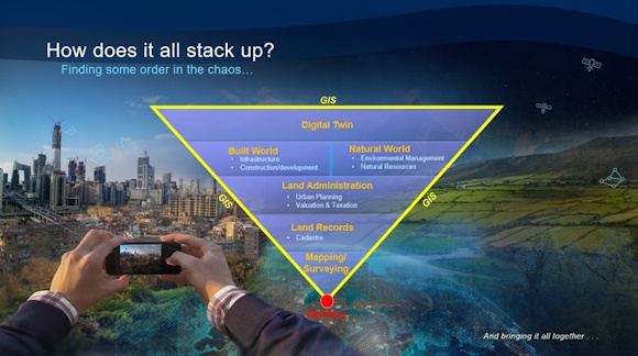
Figure 2. Putting the geospatial ecosystem into practice.
Interestingly Figure 2. Putting the geospatial ecosystem into
practice.
, the FIG commissions map quite neatly (Figure 3) to the diagram
presented above!
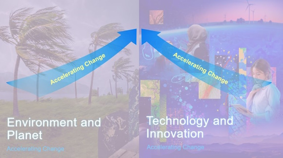
Figure 3. Relating the FIG commissions to areas of practice
represented in Figure 2.
GIS and the Geographic Approach
How does GIS put all of this data into action? It’s through
geography, which fundamentally is the science of our world. It
helps us organize everything we know – the what, when, where, and who.
GIS expands the language of geography by making everything we know
available to everyone. Anytime, anywhere across the planet.
It’s taking the tiniest bits of information and organizing them into
systems, and pretty soon we have systems of systems, and we can see how
they all interact.
We achieve this through the geographic approach. The framework
and processes to integrate all the factors – from data collection to
visualization and mapping, through analysis and modeling to
decision-making and ultimately action. Many components of the
geospatial ecosystem come into play here and are amplified by computing
and IT infrastructure.
What’s compelling is the speed at which we can now move through all
of these processes and get to the action part. Again, that’s
thanks to the innovation we explored earlier in this talk.
Once we have reached a point of conclusion, we communicate best
through maps, because they are a common language that people understand
- the language of geography. People are visual beings. Whether
they [maps] are printed out on paper or on interactive digital displays,
they are accomplishing the same things – providing clarity and making
the complexity of our world more understandable.
Creating the World You Want to See
As I mentioned in the opening, our world is evolving rapidly. While
innovation has been accelerating around us, so too are the strains on
our physical world. It impacts every one of us.
Which brings us to a point of transformation. Transformation is
defined as “a thorough or dramatic change in form or appearance.” We are
currently undergoing a transformation that can be summarized by the
convergence of two accelerating forces – dramatic changes to our
physical world, in parallel with technological advancements (Figure 4).
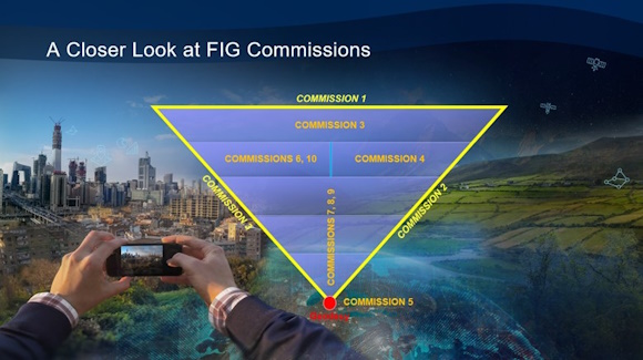
Figure 4. Converging forces of transformational change.
What should this tell us? The work we do every day in the
geospatial community is crucial. And I did say GEOSPATIAL
COMMUNITY intentionally. It takes every one of us. It
doesn’t matter if you are a surveyor, a GIS professional, a remote
sensing analyst, geodesist, researcher or educator, we must leverage the
technology, embrace the innovation, and not fear the disruption because
it is our best chance at combating the accelerating change we are
witnessing in the world around us.
What else can we do as geospatial professionals to achieve a
sustainable and resilient world? As we lean into technology and
innovation, we cannot forget some fundamental practices to ensure DATA
SUSTAINABILITY. By data sustainability, I mean collecting once and using
many times. Protect the investment in data collection. There is too much
work to be done in the world to have to repeatedly collect the same
data.
By following a few good practices, such as establishing
organizational data governance, adhering to industry standards, and
capturing basic metadata, our data can be relied upon well into the
future and not become disposable. Data is critical infrastructure, and
we must do our due diligence to ensure it remains sustainable.
The Future is Bright
Our future, I believe, is very bright. How, you might ask?
Aren’t we experiencing attrition, reduced capacity, and fewer young
people entering the profession?
Yes – absolutely. However, our young people are bright,
passionate, and perhaps most importantly, comfortable with technology
and change. I suspect they will feel the disruption less than
those of us who are ahead of them in the journey.
Remember the decades that saw the most accelerated technological
change, from approximately 2000 to the present? Those individuals
are young adults now and don’t know a world without data and information
all around them. For instance, smartphones hit the scene around
2007 – those individuals are turning 18 this year.
But each generation is vitally important – those who are more
experienced have a wealth of knowledge, experience, and wisdom to share
with the younger generations as they grow in the profession.
Because, as we all know, at the end of the day, it’s not about
technology. Technology is a powerful tool, but it’s about people,
relationships, and experiences. That’s why we all come together in
forums such as FIG Working Weeks. Helping one another grow in our
profession, and in turn, helping humanity as we solve problems together.
The future is very bright indeed. So, my geospatial friends, go forth
and leverage GIS and the geospatial ecosystem to create the world YOU
want to see.
Presentation


