Article of the Month -
July 2004
|
Revolution in Geodesy and Surveying
Prof. Gerhard Beutler, President of the International Association of
Geodesy, IAG, Switzerland
1) This paper was for
the first time presented as a keynote presentation at the plenary session of
the FIG Working Week 2004 in Athens, Greece 24 May 2004.
 This article in .pdf-format.
Key words: Geodesy, surveying, space geodesy, GNSS, education.
1. FUNDAMENTAL ASTRONOMY, NAVIGATION, GEODESY AND SURVEYING
The introduction to Peter Apian’s Geographia from 1533 in Figure 1
nicely illustrates that surveying, geodesy, positioning, navigation
and astronomy in the “glorious old times” in essence meant measuring
angles – the scale was eventually introduced by one (or few) known
distance(s) between two sites (as indicated by the symbolic measurement rod
in the center of the wood-cut).
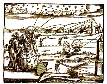
Figure 1: Peter Apian’s Geographia
Figure 1 also indicates that relative local and absolute positioning was
performed with the same instruments, the so-called cross-staffs, in Apian’s
days. Global positioning simply meant the determination of the
observer’s geographical latitude and longitude (relative to an
arbitrarily selected reference site – first several national sites, then
Greenwich was used for this purpose).
The latitude of a site could be established easily by determining the
elevation (at the observer’s location) of the Earth’s rotation axis,
approximately given by the polar star Polaris.
In principle, longitude determination was simple: one merely had to
determine the time difference (derived either by observing the Sun
(local solar time) or the stars (sidereal time)) between the unknown site
and Greenwich. The problem resided in the realization of Greenwich time at
the unknown observing site in the pre-telecommunications era.
One astronomical solution to this problem, also illustrated in Figure 1,
consisted of measuring the so-called lunar distances (angles between
bright stars and the Moon). With increasing accuracy of the (prediction of
the) lunar orbit, the angular distances between the Moon and the stars could
be accurately predicted and tabulated in astronomical and nautical almanacs
using Greenwich local time as argument. For navigation on sea the method
became obsolete with the development of marine chronometers, which were
capable of transporting accurately Greenwich time in vessels over time spans
of weeks. Figure 2 shows the first chronometer developed by the ingenious
British watchmaker J. Harrison (1693-1776).
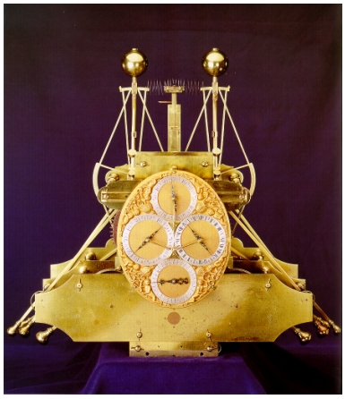
Figure 2: Harrison I, First marine chronometer
The principles of precise positioning and navigation remained
in essence the same from Apian’s times till well into the second half of
the 20th century. The development of instruments and of the achieved
accuracy was, however, dramatic: the cross-staff was replaced by
increasingly more sophisticated optical devices, telescopes in particular.
More precise star catalogues (fundamental catalogues) were produced and the
art of predicting the motion of planets was refined in celestial mechanics.
Eminent astronomers, mathematicians, and physicists, from L. Euler
(1707-1783), P.S. de Laplace (1749-1827), to S. Newcomb (1835-1909), were
steadily improving the quality of ephemerides. Highly precise pendulum
clocks and marine chronometers allowed it eventually to time-tag the
observations with millisecond accuracy.
The relationships between pure science on the one hand and precise
positioning and navigation on the other, but also between geodesy and
surveying, were truly remarkable: the discipline of fundamental astronomy
emerged from this interaction between theory and application. In
fundamental astronomy one defines and realizes the global terrestrial and
the celestial reference systems including the transformation between
the systems. The terrestrial reference system was realized by the
geographical coordinates of a network of astronomical observatories. An
accuracy of about 100 meters was sufficient for the purpose.
Until quite recently the celestial reference system was realized through
fundamental catalogues of stars. The establishment of the transformation
between the two systems implies the monitoring of Earth rotation in the
inertial space and on the Earth’s surface. Figure 3 illustrates the motion
of the Earth’s rotation axis in space.
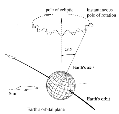
Figure 3: The Earth’s rotation axis in inertial space
It is well known that the rotation axis approximately moves on a straight
cone inclined by 23.5o w.r.t. the pole of the ecliptic, an effect known as
precession, which was already discovered in the Greek era (and usually
attributed to the great Greek astronomer Hipparchus). This motion is not
fully regular but shows short-period variations, which is why the
astronomers make the distinction between precession and nutation. A study
of ancient solar eclipses revealed eventually that the length of day is
slowly (by about 2 ms per century) growing. The Earth axis also moves on
the Earth’s surface, an effect known as polar motion. This and other
discoveries related to Earth rotation made in the era of optical astronomy
are summarized in Table 1.
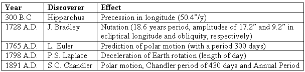
Table 1: Discoveries related to Earth rotation in the optical era
of fundamental astronomy
So far we have only mentioned the determination of geometrical
quantities, namely of
- the terrestrial reference systems,
- the celestial reference system, and
- the transformation between the two systems (i.e. the monitoring of
Earth rotation).
These quantities are the relevant objects of desire in fundamental
astronomy and navigation.
The determination of the Earth’s gravity field is a task of equal importance
in geodesy and in surveying. The importance of the gravity field becomes
immediately clear, if we recall the products derived from or associated with
it, namely
- the determination of the gravity potential from which the quasi-geoid
(or the geoid at the oceans) may be derived,
- the determination of potential differences from levelling and gravity,
which are converted to orthometric or normal heights and associated with a
local or regional height datum, and
- the determination of deflections of the vertical, used to correct
measurements referring to the plumb-line. (The IAG European Gravimetric
Geoid, EGG97, both delivers height anomalies and deflections of the
vertical).
In the pre-space era gravity field determination uniquely had to be based
on in situ measurements on (or near) the surface of the Earth.
Gravimeters, measuring the absolute value of gravity or of gravity
differences, were developed.
Other instruments, such as zenith cameras were developed, which allow the
determination of the plumb-line (the vertical), from which deflections of
the vertical may be computed.
Gravimeters and zenith cameras are examples of terrestrial tools to
determine the Earth’s gravity field. These in situ measurements are well
suited for modeling the local or regional properties of the Earth’s gravity
field. However, the global properties of the gravity field can only be
modeled using a global data distribution, which today is achieved through
satellite gravity missions, see section 2.1.
This brief review of the methods and achievements of fundamental
astronomy, navigation, surveying and geodesy reveals that all disciplines
were in essence based on the same instruments in the pre-space-age era. This
overview had the focus on positioning, navigation, and fundamental astronomy
and therefore is far from complete. Let me mention that the entire field of
photogrammetry, modeling e.g., the projection of the sky (or of a satellite
image acquired by a remote sensing satellite) onto a photographic plate, is
of highest interest to geodesy, as well. For more details concerning the
development of navigation and positioning the reader is referred to Beutler
(2003).
2. THE REVOLUTION OF GEODESY AND SURVEYING IN THE 20th CENTURY
2.1 The Advent of the Space Age, Satellite Geodesy, and Space Geodesy
The space age was initiated by the launch of the first artificial
satellite, Sputnik I, on October 4 of the International Geophysical Year
1957. With the launch of artificial satellites it became possible to use
these objects either to study the size and figure of the Earth from
space or to observe them as targets from the surface of the Earth.
The use of artificial satellites for geodetic purposes led to the
development of satellite geodesy.
The second essential development (as viewed from the point of view of
geodesy) in the second half of the 20th century is that of the Very Long
Baseline Interferometry (VLBI) technique as a new tool to realize an
extraordinarily accurate and stable inertial (celestial) reference system.
The replacement of the fundamental star catalogues by a catalogue of Quasars
for the definition of the celestial reference frame (surprisingly accepted
by both, the IUGG and the IAU in the 1990s) was an epochal event (which
passed, however, almost unnoted by the larger scientific community).
Satellite geodesy and VLBI together often are referred to as space geodetic
methods or techniques.
Today, space geodetic techniques are the primary tools to study size,
figure and deformation of the Earth, and its motion as a finite body in the
inertial reference system. Space geodetic techniques thus are the
fundamental tools for geodesy, geodetic astronomy, and geodynamics. The
development of space geodesy took place in overlapping periods. All,
except the last of these periods, are mainly of scientific interest. The
last one, the GNSS period, has had (and will continue to have) a much
greater impact. It should be viewed as the replacement of classical
navigation and positioning (which, according to Section 1 is based on the
observation of astrometric positions of natural celestial objects) by
measurements of microwave signals emitted by artificial satellites. Let us
now briefly review the periods of space geodesy:
- Optical period. Optical (astrometric) observations were made of
the first generation of artificial Earth satellites, like Sputnik 2 and
Explorer 1. The balloon satellites Echo 1 and 2 and PAGEOS (passive
geodetic satellite), which could even be seen “by the naked eye”, were
observed by a worldwide dedicated tracking network. These satellites were
(supposedly) spherical, consisted of layers of aluminized mylar foil, and,
thanks to their brightness, their tracks could easily be photographed
against the star background. Even better suited, although more difficult
to track, were smaller satellites like Geos 1 (Explorer 29) and Geos 2
(Explorer 36) equipped with flash lamps.
Fascinating results came out of this first phase of satellite geodesy. The
geodetic datums on different continents could be related to the geocenter
and thus to each other with an accuracy of about 5 meters. First reliable
coefficients of the gravity field (spherical harmonic expansion up to
degree and order of about 12-15) were also derived.
The astrometric technique, when applied to artificial satellites in the
1960s and 1970s, had serious disadvantages. The observation was day time-
and weather-dependent; the star catalogues were not of sufficiently high
quality and the processing time (time between observation and availability
of results) was of the order of a few weeks in the best case. The optical
technique therefore no longer played a significant role in space geodesy
after about 1975. Remote sensing satellites, like LANDSAT and SPOT,
producing images of the Earth’s surface, might also be mentioned in this
category. These satellites were, however, only of marginal benefit for the
determination of the Earth’s gravity field or of a highly accurate global
terrestrial reference frame.
- Doppler period. The U.S. Navy Navigation Satellite System
(NNSS), also called the TRANSIT system, had a significant impact on the
development of space geodesy. It proved that a system based on the
measurement of the Doppler shift of signals generated by stable
oscillators on board satellites could be used for positioning with a
remarkable accuracy (0.1-0.5 m relative, about 1 m absolute). The
satellites transmitted information on two carrier frequencies (400 MHz and
150 MHz) near the microwave band. The two frequencies allowed for a
compensation of ionospheric refraction. Rather small receivers connected
to omni-directional antennas made the technique well suited to establish
regional and global geodetic networks. Observation periods of a few days
were required to obtain the above stated accuracy. The NNSS satellites
were in polar, almost circular, orbits about 1100 km above the Earth's
surface. The Doppler technique is weather-independent. The Transit system
was shut down as a positioning system in December 1996 (see Kouba, 1983,
for details).
- SLR and LLR period. SLR stands for Satellite Laser Ranging, LLR
for Lunar Laser Ranging. The laser technique, developed in the 1950s, may
be used to generate high energetic short light pulses. These pulses are
sent out by a conventional astronomical telescope, travel to the satellite
(or Moon), are reflected by special corner cubes on the satellite (or
Moon) back to the telescope. The travel time of the laser pulse from the
telescope to the satellite (or Moon) and back to the telescope is measured
and corresponds (after multiplication with the speed of light) to twice
the distance between satellite and telescope at the time the light pulse
is reflected by the satellite. Today's SLR technique is capable of
determining the distance between observatories and satellites with an
accuracy of few millimeters and with a high repetition rate (up to a few
Hz). SLR techniques may be used for every satellite equipped with corner
cubes. The unique and most valuable contributions of SLR lie in the
determination of the Earth's (variable) gravity field, in the
determination of the geocenter, and in calibrating geodetic microwave
techniques. LLR measures distances between an observatory and the
reflectors deployed on the Moon by the Apollo space missions and the
Russian Lunokhod missions. The technique is, e.g., capable of measuring
directly the secular increase of the Earth-Moon distance (3.8 cm per
year). Also, LLR is well suited for evaluating gravitational theories.
- VLBI period. Very Long Baseline Interferometry (VLBI) is the
only non-satellite geodetic technique contributing to the International
Earth Rotation Service (IERS). Its unique and fundamental contribution to
geodesy and astronomy is the realization of the celestial reference system
and the maintenance of the long-term stability of the transformation
between the celestial and terrestrial reference frames. The ICRS
(International Celestial Reference System) is defined and maintained by
the (recently renamed) International Earth Rotation and Reference Systems
Service (IERS). It was adopted by the IAU and the IUGG as the primary
celestial reference system, replacing its optical predecessors based on
fundamental star catalogues. The observation and analysis aspects are
today coordinated by the IVS, the International VLBI Service for
Astrometry and Geodesy.
- Altimetry missions. Altimetry missions, based on the radar
technique, significantly improved our knowledge of the sea surface
topography, of ocean currents, of tidal motions of the oceans, etc. There
is a long list of altimetry missions including, e.g., GEOS-3, SEASAT,
ERS-1 and -2, Envisat, etc. The TOPEX/Poseidon (TOPography EXperiment for
ocean circulation) mission was the first mission which was specially
designed to study the ocean currents. For space geodesy the TOPEX/Poseidon
mission was a kind of rosetta stone mission, because its orbit was
determined using three independent systems (the French DORIS system, SLR
tracking, and the GPS). TOPEX/Poseidon was neither the first, nor will it
be the last altimetry mission (actually, its successor Jason is already in
orbit). Missions like CRYOSAT (a three-year ESA radar altimetry mission to
determine variations in the thickness of the Earth’s continental ice
sheets) and ICESAT (NASA’s mission for measuring the ice sheet mass
balance, cloud, and aerosol heights, etc.) will significantly improve our
knowledge of the Earth’s ice sheets.
- SAR and InSAR missions. Satellite missions based on the
Synthetic Aperture Radar technique and interferometric SAR (InSAR)
have the proven potential to revolutionize deformation monitoring and
measurements. As opposed to the conventional positioning techniques, SAR
and InSAR give deformation information for extended areas (up to a few
hundred km). In this sense the SAR techniques and photogrammetry are
closely related.
- Gravity space missions. For geodesy and geodynamics the CHAMP
(Challenging Mini-Satellite Payload for Geophysical Research and
Application) mission, the GRACE (Gravity Recovery and Climate Experiment)
mission, and the upcoming European GOCE (Gravity field and Ocean Current
Explorer) mission are particularly fascinating. It is expected that our
knowledge of the Earth’s gravity field (thanks to the use of spaceborne
GPS receivers, accelerometers, and gradiometers) will significantly grow
thanks to these missions. Gravity missions are of central importance for
altimetry, because the precise geoids are required to refer the sea
surface topography to the geoid.
- GNSS period. GNSS stands for Global Navigation Satellite
System. The current generation of GNSS may be viewed as the successor of
the Doppler systems. The systems are based on coherent microwave signals
(in the L-band) emitted by the satellites in (at least) two carrier
frequencies. Simultaneity of measurement of the signals emitted by
several satellites and recorded by a receiver allow for instantaneous
positioning. The GPS (Global Positioning System) is probably the best
known GNSS and, on top of that, the best known space geodetic technique
today. The system has an impact on science and society as a whole,
reaching far beyond space geodesy. GPS revolutionized surveying, timing,
pedestrian, car, marine and aircraft navigation. Many millions of
receivers are in use today. Spaceborne applications of the GPS have a deep
impact on geodesy and atmospheric sciences. Other systems, like the
Russion GLONASS and the planned European Galileo system (if/when fully
deployed) will have a similar impact in future. The impact of the GPS on
geodesy and on IAG was so significant, that this aspect will be dealt with
separately in section 2.3.
The overview in this section was based on an article on space geodesy
prepared by the author for the Encyclopedia of Astronomy (Murdin, 2001).
2.2 Revolution of IAG in the Space Age
In geodesy, as in other branches of science, one has to distinguish
between the scientific questions asked and the tools used to answer these
questions. Many questions asked today in geodesy are still the same as, or
closely related to, those asked in the 19th century (at least if the
questions are framed at a high enough level).
The technical developments related to the space age, the development of
powerful computers (note that in fundamental astronomy computers were human
beings (!)), and the development of smmunication allow it to tackle many
more questions of, and to find much more detailed answers to, classical
problems. One aspect, however, will never change in geodesy: Geodetic
problems only can be successfully addressed through international
collaboration. The discussion of the development of the IERS will underscore
this statement. The Bureau Gravimetrique International (BGI), systematically
collecting and archiving gravity(-related) information in a worldwide basis
is another excellent example of international collaboration in geodesy.
It is a noble duty of an international association to focus the interests
of its community on the relevant scientific questions using the
state-of-the-art techniques available to it. The IAG has attempted to cope
with this challenge ever since its creation in 1864. This is true in
particular in the space age – no trivial problem in view of the dramatic
evolution of the geodetic tools in the second half of the 20th century. For
more information concerning the history of the IAG the reader is referred to
Beutler et al. (2004a, 2004b).
Let us have a closer look at Earth rotation in this section. The
example nicely demonstrates how the IAG works. There are quite a few topics
in geodesy which only can be explored successfully, if a particular effect
is regularly monitored. Sea level motions (on all time scales) and Earth
rotation are two excellent examples. In such cases IAG tends to hand over
the “routine work” to a scientific service in order to ensure the
long-term availability of the raw measurements and the derived products.
An IAG service is created, if measurements and products are well defined,
regularly generated, and of importance for a large user community. The IERS,
e.g., is the IAG service dealing with all aspects of Earth rotation, the
definition and maintenance of the global terrestrial and the celestial
reference frames, and with monitoring the transformation between the two
reference systems. The IERS is a multi-technique service.
The roots of the IERS go back to the year 1899 when the ILS, the
International Latitude Service, was founded by the (predecessor of) the IAG.
Polar motion was derived from latitude observations performed at (initially)
six observatories (Mizusawa (Japan), Tschardjui (former USSR), Cagliari
(Italy), Gaithersburg (USA), Cincinnati (USA), Ukiah (USA)). The Central
Bureau of the ILS was initially located at the Geodetic Institute of Potsdam
(Director F. R. Helmert, responsible C.T. Albrecht), then moved to Japan
(Mizusawa) in 1922 with H. Kimura as director, then to Italy in 1935, to go
back to Japan in 1962 with S. Yumi as director.
With the reorganization of the international scientific associations
after the first world war, in particular with the creation of the IAU and
the IUGG, the ILS became a service working under the auspices of these two
large international unions. The IAG, now an Association of IUGG, was de
facto responsible for the ILS -- together with the IAU. A fundamental
review of the polar motion work took place in the 1950s and it was decided
to considerably expand this work. The IPMS, the International
Polar Motion Service, was to succeed the ILS with a broader mandate. The
IPMS became a service which would
- advance the study of all problems related to the motion of the pole,
- collect the observations, which can be utilized for the determination
of this motion,
- calculate the coordinates of the pole, and
- distribute the data required, and publish the initial data and
obtained results.
This mandate is close to the mandate of the IERS. It is interesting to
note, however, that the celestial and terrestrial reference frames,
implicitly needed for the work of the IPMS, were not explicitly
mentioned in the above list, because the celestial frame could be taken
from astronomy (fundamental catalogues) and the terrestrial frame from
geodesy with sufficient accuracy.
Furthermore it was not the IPMS which embraced the new space
techniques, and this mandate was then given to an IAU/IUGG joint working
group in 1978. This working group initiated and conducted the project MERIT
(Monitoring Earth Rotation and Intercomparison of Techniques of observation
and analysis). All candidate techniques, in particular optical astrometry,
Doppler tracking, SLR, LLR, and VLBI, were invited to demonstrate their
capabilities for Earth rotation monitoring. Based on the MERIT experiences
and on recommendations made by the project team, the IAU and IUGG decided to
set up the IERS (International Earth Rotation and Reference Systems
Service), which started operations on January 1, 1988. The mandate of the
IERS is to
- define and maintain the International Celestial Reference Frame
(ICRF),
- define and maintain the International Terrestrial Reference Frame
(ITRF),
- monitor the Earth rotation parameters, and
- define the standards, constants, models, etc., required for Earth
rotation work.
VLBI, SLR, and LLR were the techniques originally considered by the IERS.
It was undoubtedly a wise decision to set up the IERS as a multi-technique
service. From our perspective it would have been preferable to also have
included astrometry, because this would have added an independent technique
to determine UT1. (Also, the “transfer problem” of the celestial reference
frame from the microwave to the optical domain would have been solved in
this way.)
Figure 4 gives an impression of the achievements of the three IAG
services monitoring polar motion (the “only” product of the ILS, one of the
products of the IPMS and the IERS). Obviously the advances were dramatic, at
least in terms of accuracy. It is, however, important to point out that in
all cases one and the same aspect was studied with the state-of-the-art
tools of their respective eras.
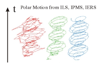
Figure 4: Polar Motion as determined by the ILS, the IPMS, and the
IERS
2.3 The Impact of GNSS Systems on Geodesy, Surveying and Other Earth
Sciences
In Section 2.1 we stated that the impact of the development of GNSS, and
of the GPS in particular, on science and society is deep and long
lasting. The impact of these systems on geodesy, surveying, and the Earth
sciences is intimately linked to yet another IAG service, the
International GPS Service for Geodynamics (IGS), later shortened to
simply the International GPS Service
According to Mueller (1993) the primary motivation in planning the IGS
was the recognition in 1989 that the most demanding users of the GPS
satellites, the geophysical community, were purchasing receivers in
exceedingly large numbers and using them as more or less black boxes, using
software packages which they did not completely understand, mainly for
relative positioning. The other motivation was the generation of precise
ephemerides for the satellites together with by-products such as Earth
orientation parameters and GPS clock information.
These ideas were discussed in 1989 at the IAG General Meeting in
Edinburgh and led soon thereafter to the establishment of a Working Group,
later re-designated as the IAG Planning Committee for the IGS, with
Ivan I. Mueller as chairman. The Call for Participation was issued on
February 1, 1991. More than 100 scientific organizations and governmental
survey institutions announced their participation. At the 20th General
Assembly of the IUGG in Vienna in 1991 the IAG Planning Committee was
restructured and renamed the IGS Campaign Oversight Committee. The
author was asked to chair the committee and accepted the honour. The
committee started organizing the 1992 IGS Test Campaign and
Epoch'92. The essential events of this first phase of the IGS
development are summarized in Table 2.
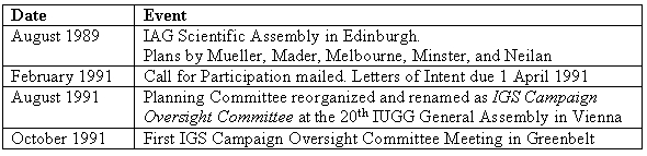
Table 2: IGS of Events 1989-1991
The 1992 IGS Test Campaign, scheduled to last from 21 June to 23
September 1992, focused on the routine determination of high accuracy
orbits and Earth Rotation Parameters (ERPs). It was to serve as the proof
of concept for the future IGS.
Epoch'92 was scheduled as a two-week campaign in the middle of the IGS
Campaign for the purpose of serving as a first extension of the relatively
sparse IGS Core Network analyzed on a daily basis by the IGS Analysis
Centers.
Two weeks after the start of the IGS Test Campaign on June 21, 1992 the
first results of the IGS Analysis Centers started to flow into the IGS
Global Data Centers, which in turn made these results available to the user
community. The ERP series were regularly analyzed by the IERS Central Bureau
and by the IERS Rapid Service Sub-bureau. Toward the scheduled end of the
IGS Test Campaign it became apparent that the campaign was an unqualified
success and that it would be most harmful to stop or interrupt the data
collection and analysis activities. Therefore, data collection and
transmission, as well as data analysis, continued on a best effort basis
after the official end of the 1992 IGS Test Campaign on 23 September, 1992.
As a consequence, the Oversight Committee decided to formally establish the
IGS Pilot Service to bridge the gap between the 1992 IGS Test Campaign
and the start of an official service. At the 1993 IGS Workshop in Bern,
devoted to the evaluation of the 1992 IGS Test Campaign and of Epoch’92,
“everybody” was confident that the IGS community was ready to support the
start of an official service in the near future.
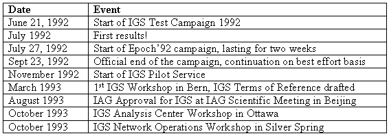
Table 3: Chronicle of Events 1991-1993
The IGS started its operations as an official IAG Service on January 1,
1994. The official IGS products, orbits, ERPs, and the satellite clock
corrections, were based on the contributions of individual IGS Analysis
Centers. So-called final and rapid products were defined and
delivered. From the technical point of view the IGS Analysis Center
Coordinator was responsible for regularly generating the IGS products in a
timely manner. Since January 1, 1994 (as a matter of fact already since June
21, 1992) this task was being performed without failure and with increasing
accuracy. This was possible because
- the IGS network grew steadily and was extremely reliable (see Figure
5),
- the data transmission, based on the Internet, was always available and
reliable,
- the IGS concept of hierarchical Data Centers worked very well,
- the IGS Analysis Centers performed their analyses in a timely fashion,
and
- the orbit, ERP, and satellite clock comparison, and the combination
strategies according to Beutler et al. (1995) proved to be reliable and
robust.
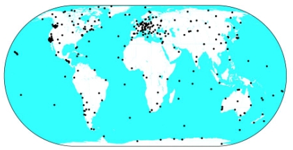
Figure 5: IGS Tracking Network in 2004
It is was felt that it was absolutely essential that the user community
be able to access reliable, robust and unique IGS products of the highest
quality within the promised time limits in addition to the products
of the individual Analysis Centers. The consistency of the IGS “combined”
products is difficult to establish, because they are based (at least partly)
on the same observations used by the Analysis Centers. They are used to
estimate a common subset of parameters in addition to center-specific
parameters.
The IGS network is undoubtedly the densest space geodesy network of
tracking stations, and therefore makes a very strong contribution to the
ITRF. Similar statements can be made about the IGS ERPs: with their
sub-milliarcsecond accuracy and their (at least) daily resolution of polar
motion, the IGS significantly contributes to the monitoring of the ERPs.
What was said so far about the development of the IGS since 1993 could be
characterized by the olympic logo “altius, citius, fortius”. The IGS
development had, however, yet another component: the IGS developed into a
multi-disciplinary service by extracting the maximum information from
the permanent IGS tracking activities. Today, the IGS should therefore be
called an Interdisciplinary Service in support of Earth Sciences, see
Beutler et al. (1999). The IGS workshops, taking place at a frequency of 1-2
per year, were extremely important in this context. They are listed,
together with other important IGS events, in Table 4.
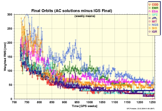
Figure 6: Consistency of IGS individual solutions
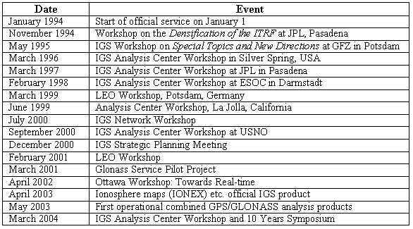
Table 4: Important IGS events 1994-present
Whenever a new aspect was studied within the IGS, a Working Group was
created. The charter of these working groups went far beyond the original
IGS charter, which focused on the core products: GPS orbits, clock
corrections, ERPs, station coordinates and velocities. The IGS extended its
activities in particular into the following domains:
- atmospheric research,
- determination of LEO orbits,
- time and frequency transfer using the GPS code and phase observables,
- exploitation of the Russian GLONASS,
- tide gauge projects, and
- development in the direction of a GNSS service.
Let us illustrate the interdisciplinarity of the IGS with an example
stemming from Fall 2003, when there was exceptionally high solar activity.
This high level of solar activity induced in turn a very high level of
ionization in the Earth’s ionosphere, which was recorded by the IGS network.
At the CODE (Center for Orbit Determination in Europe) homepage (URL
http://www.aiub.unibe.ch/igs.html) one may find a “movie” of the maps of
the exceptionally high ionospheric activity in the same timeframe. Figure 7
shows the maximum Total Electron Content observed in October 2003.
Figure 6 documents the development of the consistency of the individual
solutions of IGS Analysis Centers (mean error per satellite coordinate)
since 1993. The figure illustrates that today the consistency level of the
IGS final products is of the order of 1-3 cm. (The picture was taken from
the current Analysis Center Coordinator’s home page –
http://www.gfz-potsdam.de/pb1/igsacc/index_igsacc.html.)
2.4 The new IAG Structure and the IGGOS
The IGS, together with the IERS, pioneered the development of modern
services in the IAG, probably even in the whole of Earth sciences. Their
example was followed by the IVS (International VLBI Service for Geodesy and
Astrometry) and the ILRS (International Laser Ranging Service). These space
geodetic services, together with the IAG services related, e.g., to the
determination of the Earth’s gravity field, are of fundamental importance in
modern geodesy, and in the wider field of Earth sciences. They are part
of a very precious global geodetic infrastructure.
The development of space geodesy has had a significant impact on the new
structure of the IAG in the 1999-2003 time frame. In the new structure, the
four new IAG Commissions, established in 2003, and the IAG Services
are elements on the “same level” (Beutler et al., 2004s, 2004b). Three
service representatives are members of the IAG Executive Committee in order
to facilitate the creation of the proper interfaces between the IAG
Commissions and Services.
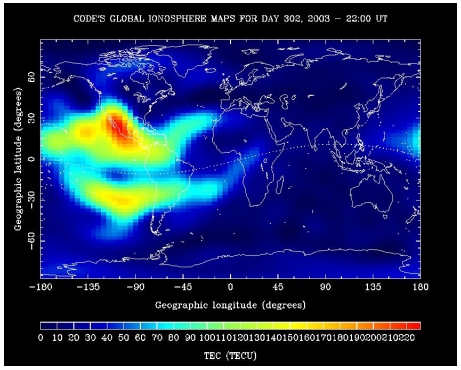
Figure 7: Maximum Total Electron Content observed on October 29,
2003 by the IGS Network
The IGS, together with all other space geodetic services, are part of our
global geodetic infrastructure. The network of gravity sites, space geodetic
missions (such as Lageos, CHAMP, GRACE, GOCE), and the network of geodetic
analysis centers are part of this global infrastructure as well. However,
this global infrastructure is not secure in times of reduced funding for
science in general. These considerations were the motivation to create the
IGGOS project in the new IAG structure.
IGGOS stands for Integrated Global Geodetic Observing System.
System should be understood as the basis on which the future advances
in geosciences can be built. By considering the Earth system as a whole
(solid Earth, atmosphere, ocean, hydrosphere, ice, liquid core, etc.),
monitoring it by geodetic techniques and by studying it from the geodetic
point of view, the geodetic community does provide the global geosciences
community with a powerful tool, consisting essentially of high quality
services, standards and references, and theoretical and observational
innovations.
IGGOS is based on the existing IAG Services. IGGOS seeks to provide a
framework for existing, or future, services and to ensure their long-term
stability. New entities will be established only if there is a stringent
requirement to do so.
IGGOS shall be recognized by partners outside the IAG, e.g., by UNESCO,
ICSU (International Council of Science), IGOS (the United Nations'
Integrated Global Observing Strategy), governments, inter-government
organizations, WCRP (World Climate Research Program), IGBP (International
Geosphere Biosphere Program), etc., as geodesy's most important contribution
to the Earth sciences.
IGGOS must promote its master product(s) and the related sub-products.
IGGOS must promote research in geodesy, provide standards and enforce
quality management (validation, calibration, at the one-ppb level and
beyond) either by a new IGGOS entity or by delegating this task to one or
several of the existing services. The initial structure to be established
for the IGGOS definition phase is simple and compatible with the existing
IAG Services. The key elements of the initial IGGOS structure are:
- the IGGOS Project Board as the central oversight entity,
- a few well defined working groups,
- the relevant IAG Services, and
- an IGGOS Science Council representing the geodetic community.
In its final form IGGOS intends to provide
- geometric products (e.g., the global terrestrial reference frame),
- gravity products (e.g., the Earth’s stationary and time varying
gravity field), and
- and the transformation between the “Earth-fixed” (the Earth rotation
parameters) and inertial reference frame,
in one and the same consistent reference system. The consistency of the
geometrical and gravitational IGGOS products at the 1 ppb or better level
are of central importance. Prof. Christopher Reigber of the
GeoForschungsZentrum (GFZ), Potsdam, is chairing the IGGOS in its definition
phase 2003-2005.
3. COMMON INTERESTS OF GEODESY AND SURVEYING
3.1 Background, Purpose and Scope
The memorandum of understanding between FIG and IAG, available at
http://www.fig.net/admin/ga/2001/appendices/mou-iag.htm and signed in
2001, provides the framework for joint FIG-IAG activities. It defines the
background and the purpose of such activities:
"The International Association of Geodesy (IAG) and the International
Federation of Surveyors (Fédération Internationale des Géomètres FIG) both
recognize that each is an international organization with many complementary
activities serving similar professional constituencies involving research
and development into varied aspects relating to surveying, engineering
surveying and surveying techniques.
FIG specializes in technical and professional areas such as positioning and
measurement, engineering surveys, hydrography, geographic information
systems, infrastructure development, land and environmental planning,
development and management, property valuation, and construction economics
and procurement.
IAG specializes in scientific and professional areas such as positioning,
advanced space technology, determination of the gravity field, general
theory and methodology and geodynamics. IAG furthermore coordinates the work
of a number of international services such as the International GPS Service.
The purpose of this memorandum of understanding is to provide an effective
framework for a continuing liaison between the two organizations, for
maintaining and increasing the opportunities of technical exchange between
their members through a continuing programme of co-operation leading to
mutual sharing of knowledge and expertise to the advantage of the membership
of both organizations."
According to this memorandum common activities include regular
contacts between the secretaries and presidents, information
concerning the organizations’ structure, encourage representation of
the other organization in the appropriate entities, participation in the
other association’s meetings.
Themes of common interest include reference frames and observing
systems, positioning, measurements and applications, hydrographic surveying
and marine geodesy, geoid determination and height systems,
applications to engineering, education, history, and cooperation with
other international organizations (UN, etc.).
The memorandum further suggests that each organization should inform the
other about its schools, seminars, etc., and consider the possibility to
organize common events of this kind.
Matt Higgins, chair of FIG Commission 5, with the help of Chris Rizos,
president of IAG Commission 4, further investigated possible common
activities considering the new structure of IAG (Higgins, 2003). The report
states in particular that the IAG Commission 4 “Positioning and
Applications” and FIG Commission 5 have strong common interests. In
addition, the report states that the IAG Service IGS is of great interest to
FIG, in particular to its Commission 5. It is also proposed that IAG should
be more closely involved in FIG regional events.
3.2 What was Achieved so far?
Quite a few of the above suggestions are currently being implemented:
- A regular information exchange at the highest level between the two
associations is taking place (the most recent one in September 2003 in
Copenhagen).
- The associations obviously (!) have the opportunity to become involved
in the each other’s major meetings. A close cooperation between FIG
Commission 5 and IAG Commission 4 are planned, e.g., in the context of the
FIG regional conference in Jakarta.
- There are examples of IAG representatives in FIG entities, and vice
versa.
All in all the contacts are good, but (perhaps) not yet too exciting. In
view of the commonalities of the two organizations, further development and
a strengthening of the IAG-FIG relationships would make sense.
3.3 Future Developments
The establishment and evolution of good relationships depends to a great
extent on the individuals involved in the process. There can be no doubt
that the current leadership of the IAG and the FIG wish to further improve
relations between their respective organizations, and to that end common
projects are strongly encouraged. Such coordination is made easier by the
facts that the headquarters of the two organizations currently are located
in the same city (Copenhagen) that the leaders of the two (most) relevant
commissions (in this context) in the FIG and IAG live and work on the same
continent (and the same country Australia).
The following options to stimulate the collaboration of the organizations
could be explored:
- Maintain the level of information and consultation at the topmost
level, as stated in the FIG-IAG memorandum.
- The contacts between FIG Commission 5 and IAG Commission 4 might be
put on a more formal basis (e.g., by having mutual representation in the
respective executive boards).
- It might make sense to create a FIG-IAG Committee, with the task of
compiling a list of concrete measures to further improve the
relationships. This list might include:
- Make the best possible use of the global geodetic infrastructure.
- Identify entities in IAG and FIG, where a cross representation seems
beneficial.
- Identify a few areas of research and application, where a
common unit might make sense (the IAG Commission ICP 1.2 on Vertical
Reference Frames might, e.g., be generalized in an appropriate way;
There seems to be room enough for both, science and application, in this
area – something that should be explored).
- Identify (well ahead of time) workshops, symposia, etc., where
common session, etc. could be organized.
- Consider the establishment of common schools (might be based on IGS
tutorials).
- Define areas where FIG and IAG might have a common representation
w.r.t. organizations like the UN (e.g., United Nations activities
related to the use and applications of Global Navigation Satellite
Systems).
- Etc.
The ideas developed here clearly are in the spirit of the MoU between FIG
and IAG. They also may be understood as a first reply to the ideas outlined
by Higgins (2003). At this point in time they should be viewed as discussion
items.
REFERENCES
- Beutler, G., J. Kouba, T. Springer (1995). Combining the Orbits of IGS
Processing Centers, Bulletin Géodésique, Vol. 69, No. 4, 200—222.
- Beutler, G. (1996). The International GPS Service for Geodynamics: The
Story. Proc, IAG Symposia No 115, pp. 3-13, Springer Verlag.
- Where is Beutler et al 1999?
- Beutler, G., M. Rothacher, S. Schaer, T. A. Springer, J. Kouba, R. E.
Neilan (1999). The International GPS Service (IGS): An Interdisciplinary
Service in Support of Earth Sciences. Advances of Space Research, Vol. 23,
631—653.
- Beutler, G. (2003). Satellite Navigation Systems for Earth and Space
Sciences. Spatium, 10 (June 2003), International Space Science Institute
(ISSI), Bern.
- Beutler, G., H. Drewes, A. Verdun (2004a). The Integrated Global
Geodetic Observing System (IGGOS) Viewed From the Perspective of History,
Proceedings of IAG Symposium “IGGOS”, IAG General Assembly, Sapporo,
Japan. In press.
- Beutler, G., H. Drewes, A. Verdun (2004b). The New Structure of the
International Association of Geodesy (IAG) Viewed From the Perspective of
History, Journal of Geodesy. In press.
- Higgins, M. (2003). The new Structure of IAG and its Relevance to the
FIG, FIG internal document.
- Kouba, J. (1983). A Review of Geodetic and Geodynamic Satellite
Doppler Positioning, Rev. Geophys. Space Phys., Vol 21, 27-40.
- Murdin, P. (ed.) (2001). Encyclopedia of Astronomy and Astrophysics,
Institute of Physics Publ., Bristol, Philadelphia.
- Mueller, I.I. (1993). Planning an International Service using the
Global Positioning System (GPS) for Geodynamic Applications, Proc.IAG
Symp. No.109 on Permanent Satellite Tracking Networks for Geodesy and
Geodynamics, Springer Verlag.
BIOGRAPHICAL NOTES
Gerhard Beutler was born in 1946 in Berne (Switzerland). Studies
of Astronomy, Physics and Mathematics at the University of Berne 1964-1971
were completed with the Diploma in Astronomy 1971 and the Ph.D. in 1976; the
habilitation (2nd doctorate) followed in 1983. His work at the University of
New Brunswick in Canada in 1983-84 was essential for the development of the
Bernese GPS-Software System between 1984 and 1991. In 1991 Gerhard Beutler
was elected as Professor of Astronomy and Director of the Astronomical
Institute of the University of Bern. The main research areas are Fundamental
Astronomy, Celestial Mechanics, and satellite-based positioning und
navigation methods. Between 1991 and 1998 Gerhard Beutler served as Chairman
of the IGS Oversight Committee (IGS=International GPS Service), then as the
Chairman of the first IGS Governing Board. From 1995 to 1999 he was
president of the CSTG (the time period when the IVS and the ILRS were
created), then he was elected as First Vice-President of IAG in 1999. He is
also a member of ESA‘s Earth Science Advisory Committee (ESAC) since 1999,
and he was granted the IAG Fellowship in 1995, that of AGU (American
Geophysical Union) in 1998.
CONTACTS
Gerhard Beutler
President of IAG
Astronomical Institute
University of Bern
Sidlerstrasse 5
CH-3012 Bern
SWITZERLAND
Tel. + 41 31 631 8591
Fax + 41 31 631 3869
Email:
Gerhard.Beutler@aiub.unibe.ch
http://www.aiub.unibe.ch
 |


