Article of the Month -
October 2012
|
Land administration for people, profit
and planet
C.J. (Kees) de ZEEUW, The Netherlands
1) This paper was presented
at FIG Working Week in Rome, 8 May 2012 and describes twelve trends
relevant for land administration systems. These trends are related to
actual and future user demand in society. Trends, developments and
proposed concepts are explained and examples are given of land
administration products, services and business approaches recently
developed at Kadaster in the Netherlands.
Key words: land administration, people, profit, planet,
products, services, business models
SUMMARY
Society is changing permanently, due to economic and political
changes, technological development and globalisation of our challenges
(environment, population, natural resources etc.). As a result we adapt
our land administration systems continuously, anticipating as good as
possible to user requirements in the (near) future.
In this paper twelve trends relevant for land administration systems
are taken as a starting point (Lemmen et al, 2011). These trends are
related to actual and future user demand in society. To provide a usable
framework for system design and maintenance, the user demand for
geospatial information is linked to the development concept of ‘people,
profit and planet’. Our information supply on land administration should
be supportive in the balanced analysis, monitoring and planning of land
use and ownership, accounting for all three of these elements. This
information modelling approach applies both to developed and developing
countries.
At Kadaster in the Netherlands products, services, the area of
application and business models change. There is a clear movement from
data deliverance activities towards (integrated) information and
knowledge supply. New business models like governmental open data policy
influences our way of work and the area of application changes both in
theme as in geography. In Europe, cross border developments become more
important. Also the role of the user changes (both professionals and the
general public), resulting in self service and crowd sourcing
initiatives. And the collaboration between governmental organisations,
universities and private companies is becoming more and more a
prerequisite for keeping pace with developments and user demands.
In this paper trends, developments and proposed concepts are
explained and examples are given of land administration products,
services and business approaches recently developed at Kadaster in the
Netherlands.
1. INTRODUCTION
Society is changing permanently, due to economic and political
changes, technological development and globalisation of our challenges
(environment, population, natural resources etc.). As a result we adapt
our land administration systems continuously, anticipating as good as
possible to user requirements in the (near) future. The society driven
evolution of land administration systems as described by de Zeeuw and
Salzmann (2011) has been translated into an analysis and overview of
long term trends (2020) and the definition of a perspective for land
administration system design by Lemmen et al (2011). The distinguished
twelve trends serve as a basis for trend analysis.
This paper aims to add a framework to these developments in order to
better understand the value of information systems to society and to
help understanding the final use of our information systems and
infrastructures in society. This is based on the practical experience
the Dutch Kadaster has, in meeting up with the rapidly developing
societal information demand in the Netherlands. The framework of ‘people
– profit – planet’ is linked to the user demand of geospatial
information infrastructures, of which land administration systems form a
part. It is believed that this conceptual framework also applies to
other countries and situations.
In chapter 4 some examples are given of how Dutch Kadaster is
developing new products and services that fit to this framework and
match with the user demands within Dutch society. This user demand is
influenced by both technological push (‘what is possible’) and societal
pull (‘what is needed’). These developments go to fast for an
organisation operating on it’s own. To meet up with the expectations
collaboration with other parties is necessary and new business models
have to be adapted.
2. TWELVE TRENDS FOR LAND ADMINSITRATION SYSTEMS
In this paper twelve trends relevant for land administration systems
are taken as a starting point (Lemmen et al, 2011). These expected
trends influence the way land administration systems are being developed
to meet up with actual and future user demands in society.
In short, the following twelve trends are distinguished:
- Mature information infrastructure – People expect a permanent
(24/7) accessible network where (geo)information is correctly linked
and versioning, multi-temporality, accuracy and quality meet the
user requirements.
- Dynamic process models – Based on well agreed information
standards (ISO, CEN, INSPIRE) it will be possible to model social
and economic processes dynamically. Future developments and impact
of policies will be established more and more using dynamic process
models.
- 3D/4D space and time administration – The increasing complexity
of modern land use will ask for more sophisticated data storage and
handling. Rapid developing technology will allow for three
dimensional and multi-temporal data storage and handling.
- Parcel design applications – Land administration systems will
evolve from registration systems towards design systems for land use
planning purposes.
- More than traditional rights, restrictions and responsibilities
– There will be a demand for a wider range of registrations like
carbon rights, water right or mining rights. This information demand
will be linked to traditional land registration systems.
- Faster and more direct updating by actors – Web services will
allow for various partners in an information chain to contribute to
the actualisation and improvement of the original datasets like the
land registry.
- International seamless registration – Due to international
standardisation (like INSPIRE) national registrations can be better
exchanged and linked. Cross border activities can be provided with
uniform data and information flows.
- Semantic web-based content – Formalized semantics will allow for
access to all information in an unambiguous and understandable way.
Also the correct exchange of data between different information
systems will be possible based on commonly shared ontologies.
- Mobile applications – Information services will develop from an
internet environment towards location based services (with internet
and mobile devices as basic services).
- Monitoring applications – Remotely sensed data and the use of
sensor networks will allow for the monitoring of changes in our
environment to be used for decision making an planning.
- Community driven cadastral mapping – Crowd sourcing techniques
may allow for more efficient and reliable collection of property
data leading to a more cost effective collection of data.
- OpenCadastreMap – (Local) communities can enforce the
recognition of customary rights by applying crowd sourcing
techniques and community driven initiatives. This will influence the
role and function of formal systems like national land registry
services.
Considering these trends, it is a difficult for land registry
organisations to keep up with the developments and demands. However,
they can’t be stopped and perhaps the most influencing trends can’t even
be foreseen at this time. This means that we have to be prepared,
flexible and willing to change our way of working and thinking.
3. APPLYING THE CONCEPT OF PEOPLE, PROFIT AND PLANET
Taking in mind these twelve relevant trends, the development of land
administration systems will become more and more user demand driven and
an inevitable part of Spatial Data Infrastructures (SDI’s).
To provide a usable framework for system design and maintenance, the
user demand can be linked to the development concept of ‘people, profit
and planet’. Insight in the issues that users have to solve can be
valuable knowledge in system design. These issues are divers, difficult
to predict and do change in time and place. Still, both for commercial
and governmental professional users, it can be expected that the use of
good land administration data in a (national) SDI, should contribute to
their corporate social responsibility. Thinking in terms of people -
profit – planet, can help in this understanding.
The principal of ‘people - profit – planet’ is used in the domain of
sustainable development (Elkington, 1994). ‘People - profit – planet’
captures an expanded spectrum of values and criteria for measuring
organizational and societal success: economic, ecological, and social.
With the ratification of the United Nations and ICLEI TBL standard for
urban and community accounting in early 2007, this became the dominant
approach to public sector full cost accounting (ref., Wikipedia). The
principals have become the basis for corporate social responsibility. By
translating this so-called triple bottom line to the design of an SDI it
can be of help understanding the future user demand of our land
administration systems.
Our information supply on land administration should be supportive in
the balanced analysis, monitoring and planning of land use and
ownership, accounting for all three of these elements. This information
modelling approach applies both to developed and developing countries.
Land administration services are considered to be an important component
of a national geospatial data infrastructure (NSDI).
In figure 1 it is shown how geospatial information is linked to this
concept of development. To clarify better, the information is translated
into three different types of information. To support ‘people’ related
information demands, so-called ‘ego-information’ is required. For
example the use of navigation systems (‘where am I?) is considered to be
a form of ego-information. ‘Profit’ related information is referred to
as ‘econ-information’. This information is necessary for making economic
choices and performing financial analysis. Our information describing
the ‘Planet’ component is referred to as ‘geo-information’ (information
describing our physical world). For example our topographic data
datasets play in important role in land use planning in the Netherlands.
But also the geodetic reference system Kadaster maintains is of an
essential value of linking the national available geo-information to the
geospatial databases in the Netherlands. Combining the three types of
information the total of information supply could be indicated as
‘Egeon-information’.
In the development of data sets and infrastructures it is important
to realise that information is required on these three different
components. So our land administration information should be of value in
describing the real world situation for people, profit and planet
purposes.
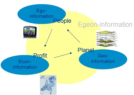
Figure 1. People, profit, planet in relation to
information sources in an spatial data infrastructure, together referred
to as ‘egeon-information’.
4. EXAMPLES FROM THE DUTCH KADASTER
Our information services are developing fast from a plain national
registering service towards a the function of a national centre for
geospatial information, required in all kind of activities regarding
planning, monitoring and analysing.
People, ego-information
Location based services and augmented reality (AR) applications become
part of societal demand. Therefore Kadaster has invested in the
facilities to present it’s data using augmented reality (using 3D
glasses or AR technology as developed by a company called Layar). Also
developments have started to provide our data to smart phones through
modern Apps (like Iphone or Android Apps), rather than using texting
services as we have used for ‘WoningWizard’. All these initiatives have
been started in close collaboration with other (commercial) parties.
In 2010 Kadaster has started a project called ‘Provisional cadastral
boundaries’. As the time between deed registration and parcel creation
after field survey is long (from 6 to 12 months), the registration and
map seems temporarily inconsistent, causing a complex database system.
Hence, a solution in the cadastral update process is being developed. In
the future mutation process, parcel creation will be done before deed
registration with provisional boundaries and parcel area. A simple
verification of geometry of the new boundaries will be done in the
terrain later on. To facilitate this process a web application (called
‘Splits!’) is being developed. This application allows the owner or
notary to prepare a request for parcel division with provisional
geometrical data of the new future cadastral boundaries, using a web
based geographic information system. In this way an extreme improvement
will be made in the actuality of the data on private and public
ownership in the Netherlands.
Profit, econ-information
Since the economic and bank crisis started in 2009, the cadastral
database in the Netherlands has gained in importance and use. It’s
function as the formal registration of property remains important, but
nowadays also the analysis of the development in the real estate market
and the value of our national mortgages have become important
information flows, provided by Kadaster. This information is made
publically available at a monthly basis through our website (see
www.kadaster.nl/perskamer/dashboard, only in Dutch). In figure 2 an
example is given of a graph representing the economic data provided on
the development of the average house price in the Netherlands in the
year 2011.
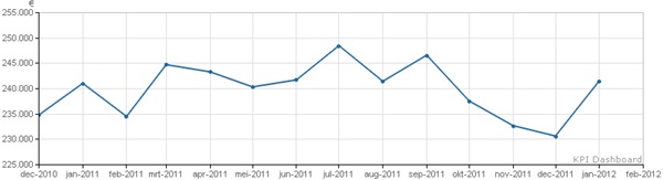
Figure 2. Example of Kadaster dashboard information,
provided on a monthly basis. In this figure the development of the
average house price is given for the year 2011.
Our web services to our professional customers are evolving rapidly.
A chain integration project for property registration (the so called
‘KIK’ project) has resulted in the possibility for the automated
acceptance and mutation of mortgage deeds and deeds of transfers, both
improving our services to notaries and banks. But not only the demands
of commercial banks are met much better, also collaboration with
national and on-line property brokers is initialised. The integration of
our information services improve their commercial web based applications
(e.g. www.woningwizard.nl,
www.funda.nl,
www.woningquote.nl).
The Key Register Cadastre, along with the Municipal Personal Records
Database (GBA) is accessible via the
www.MijnOverheid.nl website.
After identifying themselves using their electronic ID, private
individuals can consult the rights that have been registered for them in
the Key Register Cadastre. This consultation is free of charge. In the
event people believe they are registered incorrectly, they can report
these errors via the Kadaster website, again using their electronic ID
for identification purposes.
Planet, geo-information
Kadaster has added many new registers and services to its responsibility
the last few years (like topography, addresses, buildings and pipes and
cables). As a consequence much information necessary to describe the
physical state of our country in for example a map, comes from Kadaster
in the form of authentic registrations. This authenticity is essential
for the national need to map and describe our country in an consistent
way allowing for planning, analysing and monitoring our real world
situation in virtual worlds using geographic information systems. Our
national topographic maps (from scales 1:10.000 to 1:1.000.000) serve as
reference maps for all kind of presentations.
In order to link the virtual mapped world to the real world situation
a good quality reference system is needed. According to modern standards
Kadaster maintains this national reference system (called NETPOS) in
collaboration with the Dutch Ministry of Infrastructure and Environment.
5. IMPACT ON KADASTER
At Kadaster in the Netherlands products, services, the area of
application and business models change. There is a clear movement from
data deliverance activities towards (integrated) information and
knowledge supply. New business models like governmental open data policy
influences our way of work and the area of application changes both in
theme as in geography. In Europe, cross border developments become more
important. Also the role of the user changes (both professionals and the
general public), resulting in self service and crowd sourcing
initiatives. And the collaboration between governmental organisations,
universities and private companies is becoming more and more a
prerequisite for keeping pace with developments and user demands.
To fulfil the demands of our customers and society, Kadaster has a
strong focus on the innovation of products (the ‘what?’ question) and
processes (the ‘how?’ question). A firm investment in information
technology and infrastructure is indispensible to meet up to these
requirements. Nevertheless, it is clear that the solution will not be in
making things bigger and bigger. There is a limit to possibilities of
up-scaling. Keywords these days are ‘open source, the crowd and the
cloud’.
As community driven software development reaches a quality level
comparable to commercial software packages, the use of open source
software becomes within reach of governmental organisations. Especially
as the technical support of open source software is taken up, as a new
service, by private companies. Kadaster has a cautious policy in the use
of open source software, but is open for development. The use of open
versus closed source software is highly related to the security level
and life cycle of applications. For database management systems our
closed source systems are still in place. In the field of analysis and
operational tools a mixture of closed source and open source arises,
while at the front end (portals, web interfaces, etc.) a majority of
open source applications develops.
With respect to ‘crowd sourcing’ (or voluntary geo-information
provision), Kadaster is a partner in several pilot projects, involving
the general public in data provision for our key registries. This paper
will not go into detail on possibilities and limitations. But an
important restriction one should realise is that in our case crowd
sourcing for cadastral purposes is not a community based initiative, but
an effort to support a professional organisation in cost efficient data
gathering and provide services tot the general public that without their
contribution would not be possible. This requires a different attitude
from both the Kadaster as from the volunteers providing this data. In
2012 Kadaster launched an App called ‘Grenspalen’ (available in Dutch).
This App is freely available through the different App stores (Apple and
Android) and refers to locating the exact position of border poles on
the border between Germany and the Netherlands. By giving the position
of this border poles freely available to the public it becomes possible
for them to follow hiking routes following the national borders and to
give direct feedback to Kadaster on the position and state of the poles
to Kadaster, using mobile devices. New recreational services are
provided to the public (‘searching border poles’) and information on the
status of the border post is given to Kadaster on low cost basis (it is
not longer necessary to visit the poles on regular basis by
professionals).
In the IT world ‘cloud computing’ is strongly believed to be the only
way to keep up track with user demands for data retrieval, management
and analysis. Commercial parties start offering software, platforms,
infrastructures and services in a cloud environment. Kadaster is in a
phase of reconnaissance of our possibilities. It is realised that it is
unavoidable and offering a lot of potential, but also that many quality
and security issues are still to be solved or to be clarified , before
certainly right data can be brought into ‘the cloud’.
At the national level the demand for an Open Data policy is growing
in the Netherlands. Data from national key registers should become wider
available among governmental organisations, for research institutes and
also for commercial use by private companies. As the collection,
management and provision of data is not a cost free activity, many
(political) discussions took place on how data can be made available in
a open way, maintaining the high standard on quality, actuality and
reliability that exist on (authentic) registers in the Netherlands. As a
first step, in January 2012 the topographic data of Kadaster have been
made available under an Open Data policy. This means that a new business
model has been defined for the cost recovery of the services Kadaster
provides and new license models for the use these data have been
established. A challenging development, with high societal impact.
Apart from the financial investment that is required to meet the
actual societal user demands for our data and services, effort is being
put into capacity building of our own personnel and the clever building
up of networks and alliances. Our organisation transforms from a
production type organisation into a knowledge driven shared service
centre, with a national and international importance. This asks for
continuous adjustments to our position, personnel and functions. Coming
from a national monopolist situation, we become more and more an
indispensible link in a chain and an international context. Its becomes
our task to co-create the evolution of land administration and spatial
data information systems. We have to match users’ expectations and
technical possibilities with existing (and often sound) legal and
business rules and processes.
6. BUSINESS STRATEGY OF THE NETHERLANDS KADASTER
The traditional integrated approach of cadastre and land registry in
the Netherlands (and the movement towards more positive legal status of
the registration) has been extended with the national topographic
mapping since the late nineties. Recently also services for addresses,
buildings, cables and pipes have been added to our organisation’s
responsibilities. In 2012 it is expected that the national information
provision service for taxation on housing and the large scale base map
of the Netherlands will be added to this. Kadaster as an organisation is
moving towards a national centre for geo-information services, rather
than a pure cadastral agency as the name implies.
To comply with our rapid changing environment Kadaster is evaluating
its approach and policy on a yearly basis in relation to its long term
policy which has a five years cycle. The key targets for the policy
period 2012 – 2016 are defined as:
- Offering services that suit our customers needs
- Collaboration with partners (government, science and industry)
- Cost control
- Flexibility
- Quality and continuity
7. CONCLUSIONS
Looking back at the last decade, we can conclude that our systems and
products have changed a lot. Not only many new services have been
developed based on the same set of basic data, but also many new
registrations have become part of an integrated geo-information
organisation, as Kadaster is today. The use of our data and services is
being applied in the domain of people, profit and planet.
Regarding the trends as described in this paper organisations like
Dutch Kadaster need to adapt and rethink the design of it’s systems,
services and strategy. Thinking in terms of ‘people – profit – planet’
with respect to the user demand of our data provision and services helps
in understanding the (future) needs when we define our systems and
services. New challenges for Dutch Kadaster are defined by the crowd,
the cloud, open source and open data. This asks for permanent evaluation
of our business strategy and further collaboration with other parties
from government, research organisations and private companies.
REFERENCES
- Elkington J. (1994), Towards the sustainable corporation:
Win-win-win business strategies for sustainable development.
- Lemmen C., P. van Oosterom, C.J, de Zeeuw and M. Salzmann, M.
Wubbe (2011), Society driven innovations in Land administration. 3rd
Cadastral conference, Warsaw, 23 – 25 November, 2011.
- Zeeuw de, C.J. and M. Salzmann (2011), Cadastral innovation
driven by society: evolution or revolution? FIG working week,
Marrakech, Morocco.
BIOGRAPHICAL NOTES
Kees de Zeeuw is director of Kadaster International, part of Cadastre.
Land Registry and Mapping Agency (Kadaster) of the Netherlands. He has
an academic background in environmental and geo-information sciences
working at Wageningen University and ResearchCentre. After three years
being responsible at Kadaster for product and process innovation at the
GEO department (2007 – 2010), he now is responsible for the coordination
of Kadaster’s international activities and international cooperation
projects. Kadaster International provides world wide advisory services
in the domain of land administration, e-governance, geo-information
services and spatial data infrastructures.
CONTACTS
C.J. (Kees) de Zeeuw
Director Kadaster International
Kadaster, the Cadastre, Land Registry and Mapping Agency
P.O. Box 9046
7300 GH Apeldoorn
THE NETHERLANDS
Tel. +31 88 183 4417
Email:
kees.dezeeuw@kadaster.nl
Web site: www.kadaster.nl

|


%20de%20ZEEUW.jpg)