Article of the Month - October 2020
|
SPARQLing Geodesy for Cultural Heritage – New
Opportunities for Publishing and Analysing Volunteered Linked (Geo-)Data
Florian Thiery, Timo Homburg, Sophie Charlotte
Schmidt, Germany, Martina Trognitz, Austria And Monika Przybilla,
Germany
This article in .pdf-format
(15 pages)
 |
 |
 |
 |
 |
| Florian Thiery |
Timo Homburg |
Sophie C Schmidt |
Martina Trognitz |
Monika Przybilla |
SUMMARY
Geodesists are working in Industry 4.0 and Spatial Information
Management by using cross linked machines, people and data. Moreover,
open source software, open geodata and open access are becoming
increasingly important. As part of the Semantic Web, Linked Open Data
(LOD) must be created and published in order to provide free open
geodata in interoperable formats. With this semantically structured and
standardised data it is easy to implement tools for GIS applications
e.g. QGIS. In these days, the world’s Cultural Heritage (CH) is being
destroyed as a result of wars, sea-level rise, floods and other natural
disasters by climate change. Several transnational initiatives try to
preserve our CH via digitisation initiatives. As best practice for
preserving CH data serves the Ogi Ogam Project with the aim to show an
easy volunteered approach to modelling Irish `Ogam Stones` containing
Ogham inscriptions in Wikidata and interlinking them with spatial
information in OpenStreetMap and (geo)resources on the web.
INTRODUCTION
Geodetic methods are constantly developing: Traditionally geodetic
methods were based on analogue measurements (Geodesy 1.0); moving into
the digital era, in which digitisation and data publishing in standards
on the web speeded up using web mapping platforms like geoserver,
leaflet or open layers (Geodesy 2.0); into the semantic era, where
semantic modelling and publication of Linked (Geo)Data prevail (Geodesy
3.0). Today, geodesists record, save and process machine-readable data
via the World Wide Web (WWW). We are now at the threshold of what we may
call the knowledge era, in which the machine analyses and creates new
knowledge through Artificial Intelligence (AI), Machine Learning (ML) or
semantic reasoning (Wahlster 2017). To fully achieve Geodesy 4.0,
several challenges must be tackled. Geodesists experience the Industry
4.0 (Lasi et al. 2014) and Spatial Information Management in everyday
work by using linked machines, people and data. Geodata is an important
fuel of the digital society, as about 80% of the generated data has
spatial contexts (Hahmann & Burghardt 2012). The OOO model consisting of
Open Source Software, Open (Geo)data and Open Access (Mayer 2016) leads
to geodesists working digitally in the cloud using generally accepted
standards. The development of the cloud and the web to a Web 4.0 (Aghaei
2012) includes the publishing of Linked Data (LD), Linked Open Data
(LOD) and Linked Open Usable Data (LOUD). Providing free open geodata in
interoperable formats creates parts of the Semantic Web (Berners-Lee,
Hendler and Lassila 2001). Some administrative agencies, as well as
community driven volunteered databases, provide geodata as LOD,
interlinked with several resources on the web. They are continuously
growing as they become enriched with source information and linked to
related material in other official databases. A combination of these
repositories, as well as databases of different domains, such as natural
sciences or Cultural Heritage (CH), form a Linked Open Data Cloud
creating Geospatial Big Data (Kashyap 2019). If this geodata is
semantically structured and standardised it can therefore be easily
implemented in tools such as QGIS. The world’s CH is constantly in
danger of wars, sea-level rise, natural disasters and the impacts of
climate change. Therefore, several transnational initiatives try to
preserve as much information as possible on CH objects via
digitalisation and geospatial analysis, e.g. the
Syrian Heritage Archive
project (Pütt 2018), the Ogham
in 3D project (Bennett, Devlin and Harrington 2016) or the
documentation of the
Rock Art in
Alta (Tansem and Johansen 2008). In addition, volunteered databases
allow everyone to easily assert digital CH items as LOD. Thereby, the
digital CH cloud will grow in the upcoming years, which makes it crucial
for the geospatial community to take an active role in the technical
(geodetic) evolution in order to reach Geodesy 4.0. In this paper we
consider steps and workflows needed to reach one prerequisite for
Geodesy 4.0: Implement Linked Open Data standards of the semantic era
(Geodesy 3.0) for CH data. Starting with geospatial data modelling
standards (cf. section 2) we will give a general introduction into the
concept of Linked Data (cf. section 3), followed by the most common
Linked Geodata ontologies (cf. section 4), an insight into LOD
(geo)datasets (cf. section 5) and the idea of Wikidata (cf. section 6).
Next, we introduce the famous SPARQL unicorn (cf. section 7), give
examples of Linked Geodata in action (cf. section 8) and showcase a best
practice example using Wikidata and Linked Data in the Ogi Ogham Project
(cf. section 9)
2. GEOSPATIAL DATA MODELLING AND STANDARDS
Geodesists invented a lot of standards to exchange their geospatial
data, e.g. EPSG codes for
projections. Starting in the Geodesy 2.0 era, standards for digital data
modelling were created and applied to enable interoperability, data
exchange and reusability, e.g. GML (Portele 2007), OGC web services,
GeoJSON, GeoSPARQL and
Neo4J spatial functions (Agoub, Kunde and Kada 2016). The OGC
provides a variety of web service definitions, in order to provide,
process and display geospatial data to the Geospatial community. WFS
Services (Vretanos 2005) give access to vector datasets, WCS Services
(Benedict 2005) enable the download of raster data, WMS Services
(Wenjue, Yumin and Jianya 2004) offer pre-rendered maps and CSW Services
(Nogueras-Iso et al. 2005) provide an overview of different available
aforementioned web service types. A common problem in the geospatial
sciences is that those services are not interlinked among each other,
except for the CSW services. In particular, links inside datasets to
other datasets are not possible, only external links to an entire
dataset can be provided. GeoJSON is a
community-driven data format that displays vector data which emerged in
2008 from the need to create a simple JSON-based (Severance 2012) format
for sharing geospatial data on the web (Butler et al. 2016). GeoJSON
became a de-facto web standard which is today often used as a means of
geospatial data provision for web applications such as
Leaflet or JavaScript-based
frameworks, or as a common return type in OGC web services. This
standard defines geospatial features and Feature Collections whereas a
feature is comprised out of a geometrical part which includes
geo-coordinates, the geometry type and a list of key/value pairs
describing the properties of the respective feature. Several extensions
have been proposed for GeoJSON, such as
GeoJSON-LD for linked data
and GeoJSON-T for
temporal aspects. Recently, the
CoverageJSON format has been standardised to represent coverages and
their annotations in JSON. The GeoSPARQL standard (Battle and Kolas
2012) defines both a vocabulary to encode geospatial features and a
query extension to the SPARQL query language (Prud’hommeaux and Seaborne
2008) allowing the definition of geospatial relations.
3. LINKED (OPEN USABLE) DATA
Wuttke (2019) shows that areas which are unknown to the map creator
were described in ancient times by the phrase `Hic sunt dracones` (engl.
here be dragons). Today the web gives geodesists the possibility of
sharing their geodata and enables them to participate in the scientific
and political discourse. However, much of this shared data is not
findable or accessible, thus resulting in modern unknown data dragons.
Often these data dragons lack connections to other datasets, i.e. they
are not interoperable and can therefore lack usefulness, reusability or
usability. To overcome these shortcomings, a set of techniques,
standards and recommendations can be used: Semantic Web and Linked
(Open) Data, the FAIR principles (Wilkinson et al. 2016) and LOUD data.
Tim Berners-Lee introduced the concept of Semantic Web, by using the
ideas of Open Data, semantically described resources and links, as well
as usable (machine readable) interfaces and applications for creating a
Giant Global Graph (Thiery et al. 2019). “The Semantic Web isn't just
about putting data on the web. It is about making links, so that a
person or machine can explore the web of data.” (Berners-Lee 2006). A
five star rating system of openness (Hausenblas and Boram Kim 2015) was
introduced to rate Linked Data, i. e. “Linked Open Data (LOD) is Linked
Data which is released under an open licence.” (Berners-Lee 2006).
Furthermore, LOD must be usable for scientists and programmers in order
to take full advantage of all the LOD power. Following the LOUD
principles (Sanderson 2019) will make LOD even more FAIR.
4. LINKED OPEN GEODATA ONTOLOGIES
The Linked Open Data principles mentioned in section 3 are applied in
several Linked Open Data projects across all domains, e.g. geodesy,
humanities and natural sciences. The
WGS84 Geo Positioning
RDF vocabulary (GEO) is a lightweight common used LOD vocabulary
representing latitude, longitude and altitude information in the WGS84
geodetic reference datum (Atemezing et al. 2013). The GEO vocabulary is
used e.g. in the nomisma project as a
Linked Data hub for ancient coins (Gruber 2018). The GeoSPARQL ontology
(cf. section 2) defines the concepts of a spatial object which is broken
down into a feature part describing its semantic meaning and a geometric
part. The geometric part includes serialisations of the respective
geometry as literal descriptions in either WKT or GML, providing a class
hierarchy of GML and WKT Geometry concepts respectively. Properties of
the respective geospatial entity are annotated at instances of the
Feature class which is linked to the geometrical representation.
GeoSPARQL is used in projects such as LinkedGeoData and the SemGIS
project (section 8.1).
5. LINKED OPEN GEODATA
The Linked Open Data Cloud
offers large data repositories which can be used by different
communities, for various purposes. The strength of Linked Open Data
(LOD) is the linking of information from a wide variety of decentrally
hosted knowledge domains. For the geoinformatics domain, community-based
data repositories published their data. Moreover, gazetteer repositories
and administrative providers also offer their geodata as LOD.
GeoNames (Hahmann and Burghardt
2010; Khayari and Banzet 2019) aims to be the first geospatial Linked
Data gazetteer by linking geographical names to geo coordinates to
facilitate geocoding and the usage of geographical places in other
Semantic Web contexts. In a joint project between
Ordnance Survey Ireland (OSi) and
ADAPT research centre at Trinity College Dublin, Ireland’s geospatial
information has been made
available as Linked Data on a dedicated portal (Debruyne et al.
2017). The Placenames Database of Ireland, Bunachar Logainmneacha na
hÉireann (Logainm), is a
management system for research conducted by the State. It was made
publicly available as Linked Open Data for Irish people at home and
abroad, and for all those who appreciate the rich heritage of Irish
placenames (Lopes et al. 2014). The
Ordnance Survey (OS)
offers several British datasets as geospatial data (Goodwin, Dolbear and
Hart 2008; Shadbolt et al. 2012). OS has published the 1:50 000 Scale
Gazetteer, Code-Point Open and the administrative geography for Great
Britain, taken from Boundary Lines.
LinkedGeodata.org (Stadler et al. 2012) created an ontological model
for OpenStreetMap geospatial concepts, which in OpenStreetMap may be
defined as tags or key/value combinations of tags. This allowed the
Linked Data community to access a repository of geospatial data, while
at the same time opening the semantic concepts of a Volunteered
Geographic Information (VGI) world map to the Semantic Web community for
further analysis. Pleiades
(Simon et al. 2016), similar to GeoNames, created a gazetteer of
geographical names for ancient places to allow historical researchers to
link their findings to a unique identifier, indicating a place in time
of historical significance.
6. WIKIDATA
Wikidata (Vrandečić and Krötzsch 2014) is a secondary database for
structured data, established in 2012. It is a free and open knowledge
base where anybody can add and edit data. It is the central storage for
structured data of Wikimedia projects, e.g. Wikipedia and Wiktionary.
Data held within Wikidata is available under a free licence (CC0), it is
multilingual, accessible to humans and machines (GUI, API, SPARQL),
exportable using standard formats (e.g. JSON, RDF, SPARQL) and
interlinked to other open data sets in the Linked Data Cloud.
Wikidata’s data model
contains items (e.g. label, description, alias, identifier) and
statements (e.g. property, value, qualifier, reference), cf. Trognitz
and Thiery (2019). The Open Science Fellows Program is aimed at
researchers who want to promote their research in an open manner, an
example being Martina Trognitz in
A Linked and Open Bibliography for Aegean Glyptic in the Bronze Age.
7. SPARQL UNICORN
In humanities and geospatial related research documentation,
databases and their analyses play a central role. Some of these
databases are available as online resources. However, very few are made
openly available and accessible and even less are linked into the Linked
Open Data Cloud. This hinders comparative analyses of records across
multiple datasets. Nevertheless, there is one database that has been
around since 2012 and recently gained momentum: Wikidata (cf. section
6). We would like to propose the SPARQL unicorn as a friendly tool
series for researchers working with Wikidata. The unicorn’s aim is to
help researchers in using the community driven data from Wikidata and
make it accessible to them without expertise in LOD or SPARQL (Trognitz
and Thiery 2019). One existing implementation of the SPARQL unicorn is
the SPARQL unicorn QGIS Plugin, cf. section 8.2. Another implementation
using the unicorn for combining SPARQL and R for statistical analysis is
currently under development. First results are visible in section 9.2.
8. LINKED OPEN GEODATA IN ACTION
Linked Open Data and Linked Geodata are not only theoretical
concepts. The data in the Linked Data Cloud as part of the Semantic Web
is used in several projects to help the scientific and geo-community to
address their challenges using Linked Data techniques. The following
sections will describe two research projects dealing with applied Linked
Data.
8.1. SemGIS project
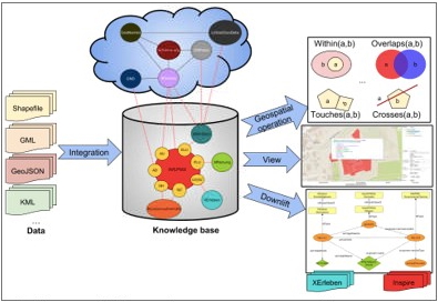
figure 1: Overview of a Semantic GIS System,
heterogeneous geospatial data is integrated into an ontological
structure, the so-called knowledge base which is in turn interlinked to
the Linked Open Data Cloud. The integrated system allows for queries
downlifts in other geospatial data formats and may provide views for
parts of geospatial data. (CC BY 4.0 Timo Homburg, Claire Prudhomme)
The SemGIS project was a research project conducted by Mainz
University of Applied Sciences which aimed at finding methods to
integrate GIS data into a semantic context for the purpose of data
integration, interlinking, reasoning and finally data application. To
that end so-called Semantic Uplift and Downlift methods have been
developed, which allow for the conversion and semantic enrichment of
geospatial data in heterogeneous formats. Semantic Uplifts may be
performed on data without a given schema description (Prudhomme et al.
2019), on common geospatial formats using pre-extracted
ontologies and
an automated converter (Würriehausen, Homburg and Müller 2016) using
mapping schemas on databases. The GeoSPARQL query language has been
thoroughly investigated to come up with proposals on how to extend the
language to cope with coverage data, geometry manipulations in-query and
the handling of further geospatial data formats. Such proposals are
currently
discussed in the OGC GeoSemanticsDWG special interest group for
standardisation. Finally, Downlift approaches, which result in making
SPARQL accessible by means of traditional GIS web services, are
currently applied in a pilot study at the German Federal Agency for
Cartography and Geodesy to pioneer a linked data powered spatial data
infrastructure which is interlinked to other governmental and VGI data
sources, cf. figure 1. Application cases tackled by the SemGIS project,
include the assessment of disasters, specifically the simulation of
floods and action response systems supporting crisis management. Here,
information of different sources needs to be acquired, combined and
finally evaluated which was accomplished using reasoning rules. For
example: A rising flood level would trigger a change in the ontological
model which would in turn trigger corresponding rescue units to respond
in an appropriate manner. In this way, semantics support a real-world
application case which could only be realized using considerable efforts
using traditional GIS integration methods of Geodesy 2.0.
8.2. SPARQL Unicorn QGIS Plugin
Sections 5 and 6 give an insight into community-based data
repositories that may be used by geodata domain experts, such as
Wikipedia or LinkedGeoData. Furthermore, gazetteer repositories e.g.
GeoNames or Pleiades, are publishing their (ancient) spatial data as
LOD. Moreover, administrative providers like the OS or OSi model provide
geospatial data, containing linked information, into the Linked Open
Data Cloud. Unfortunately, all these LOD resources have become of minor
importance in the geo-community. This is due to a lack of support for
GIS applications in processing LOD. Triplestores and SPARQL are
currently not supported by GIS software, GeoServer implementations or
OGC services. The Linked Data serialization GeoJSON-LD poses challenges
due to some outstanding issues but is not often used in applications
like its unsemantic sister GeoJSON. This is exactly where the
SPARQLing
Unicorn QGIS plugin comes into play. The plugin enables the
execution of Linked Data requests in (Geo-)SPARQL to selected
triplestores and geospatial capable SPARQL endpoints. The results are
converted into GeoJSON layers, so that they can be used directly in
QGIS. In the future, the SPARQLing Unicorn plugin will offer users the
possibility to automatically generate simple queries - out of extracted
concepts of selected ontologies - such as `Give me all cultural heritage
sites in BOUNDINGBOX with directly connected relations` and thus make
loading more dynamic content of data repositories possible. It is
desired that the geo community takes an active part in the (further)
development of the plugin, thus making the world of LOD known in the geo
context. The source code is freely available for forking on
GitHub.
9. THE OGI OGHAM PROJECT
Stones carrying Ogham inscriptions are found in Ireland and the
western part of Britain (Wales and Scotland). Ogham stones mainly served
as memorials and/or boundary markers as well as indicators of land
ownership and contained relationships as well as personal attributes.
They date from the 4th century AD to the 9th century AD (MacManus 1997).
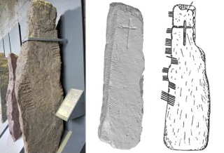
figure 2: left: Ogham Stones -
CIIC 81 at University College Cork (UCC) (CC BY 4.0
Florian Thiery via Wikimedia Commons), middle:
CIIC 180 as 3D view using MeshLab (CC BY-NC-SA 3.0
Ireland
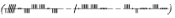
http://www.celt.dias.ie), right: CIIC 180 (Macalister
1945:173) carrying the inscription BRUSCCOS MAQQI CALIACỊ
One of the largest publicly available
collections of Ogham stones is in the Stone Corridor at University
College Cork (cf. figure 2, l.). Probably the most complete standard
reference is found in Macalister (1945, 1949), who established the CIIC
scheme. The Ogham in 3D project
currently scans Irish Ogham stones and provides the data, metadata and
3D models (cf. figure 2, m.) for the community. Ogham inscriptions
contain formula words like MAQI
 son, e.g. figure 2, r.) or MUCOI
 tribe/sept).
The Irish personal name nomenclature reveals details of early Gaelic
society, e.g. CUNA
tribe/sept).
The Irish personal name nomenclature reveals details of early Gaelic
society, e.g. CUNA
 wolf/hound) or CATTU
 battle), details in Thiery (2020) and MacManus (1997). The idea
of the Ogi Ogham Project is to provide the Ogham stones, their content,
the relationships of the people noted on stones, their tribal
affiliations and other metadata as Linked Open Data; thus enabling
semantic research processing by the scientific community. The project
group creates a semantic dictionary for Ogham, which is done by a
dynamical
extraction from text sources using natural language processing
methods of keyword extraction. The relevant keywords were collected from
the literature Thiery (2020). Linked Ogham Stones allow the following
research questions to be addressed by linking knowledge and enriching
it: (i) classification of stones (e.g. family hierarchy) and (ii)
visualisation of relationships in maps generated by LOD. As a fundament
for the analyses, we rely on a Wikidata retro-digitisation of the CIIC
Corpus by Macalister (1945, 1949), EPIDOC data of the Ogham in 3D
project and on the Celtic Inscribed Stones Project (CISP)
database (Lockyear 2000). Furthermore, we actively maintain missing and
suitable elements in Wikidata (cf. section 9.1) to provide the data to
the research community in the sense of the SPARQL Unicorn (cf. section
7).
battle), details in Thiery (2020) and MacManus (1997). The idea
of the Ogi Ogham Project is to provide the Ogham stones, their content,
the relationships of the people noted on stones, their tribal
affiliations and other metadata as Linked Open Data; thus enabling
semantic research processing by the scientific community. The project
group creates a semantic dictionary for Ogham, which is done by a
dynamical
extraction from text sources using natural language processing
methods of keyword extraction. The relevant keywords were collected from
the literature Thiery (2020). Linked Ogham Stones allow the following
research questions to be addressed by linking knowledge and enriching
it: (i) classification of stones (e.g. family hierarchy) and (ii)
visualisation of relationships in maps generated by LOD. As a fundament
for the analyses, we rely on a Wikidata retro-digitisation of the CIIC
Corpus by Macalister (1945, 1949), EPIDOC data of the Ogham in 3D
project and on the Celtic Inscribed Stones Project (CISP)
database (Lockyear 2000). Furthermore, we actively maintain missing and
suitable elements in Wikidata (cf. section 9.1) to provide the data to
the research community in the sense of the SPARQL Unicorn (cf. section
7).
9.1. Ogham data modelling in Wikidata
For inserting, publishing and maintaining Wikidata’s data the
software OpenRefine is recommended
(Association of Research Libraries 2019). First, the data will be
imported via CSV. Second, an open refine model for mapping the CSV
import files has to be created. Third, a Wikidata mapping scheme model
for maintaining the entities needs to be established. In the Ogi Ogham
Project it is done in Thiery and Schmidt (2020a) for townlands and in
Thiery and Schmidt (2020b) for the Ogham stones. In this paper, we would
like to focus on the townland modelling from old textual resources, as
well as from database entries which rely on outdated text sources.
Drawing on Macálisters Corpus Inscriptionum Insularum Celticarum (1945,
1949) enabled a geospatial placement of the Ogham stones on the level of
townlands. A townland (Irish baile fearainn) is a
small geographical
classificatory unit in Ireland and of Celtic origins, though their
boundaries, names and locations may shift over time. Macálister’s
catalogue is ordered by county, barony and townland, therefore this
information was used to identify the modern townland to which to link
the Ogham stone. The first resources for comparison were: townlands.ie
(based on OSM) and logainm.ie (cf. section 5). Several problems arose
during this process. They can be classified as:
- locations
unknown to Macálister
- mistakes made by Macálister
(typographical errors, wrong place names)
- imprecise
information given by Macálister
- the occurrence of several townlands
with the same name in this barony
- not giving precise names, such as
leaving out `upper` or `lower`
- not providing a townland, but giving
a town or electoral division
- a shift in the structure of
baronies, electoral divisions and townlands between 1945 and 2020
In
many cases, it was not possible to determine which of the above was the
problem. Whether there was a shift in the naming of the townland or
whether Macálister made such a grievous typographical error that one
could not reconstruct the name led to the same result: The townland
could not be identified. This is a common problem. The National
Monuments Service of Ireland holds a
database of
archaeological finds uploaded by the Department of Culture, Heritage
and the Gaeltacht, with which we could check our information and which
also has a number of unknown locations registered. Nonetheless, in this
database a few decisions had been made by local experts to which we
adhere (16 times; e.g. for CIIC 204 we followed their advice that
Macálister made an error in naming Curraghmore West instead of East).
Logainm was also helpful, as a townland given there was linked to a
monument, which was used as localisation by Macálister. Further
information given by Macálister proved to be invaluable: In seven cases
of imprecise place names given in the catalogue, we could use his
additional description to improve the precision of the spatial data. For
example, Macálister elaborated that the stone CIIC 54 was built into the
cathedral of the town, or that a stone was found south of the village
(CIIC 48), which enabled us to choose a very probable townland. On a few
occasions, we resorted to using the larger of the two townlands with the
same name, if they were located right next to each other, verifying this
educated guess with the help of the Department of Culture, Heritage and
the Gaeltacht. All in all, we managed to locate 185 of 196 townlands
mentioned by Macálister. We enriched the data set with information such
as: the name of the townland, the Gaelic name of the townland (alias),
it’s province, county, barony, civil parish, the electoral division it
belongs to, a point coordinate, OSM ID, logainm ID, OSi GeoHive IDs, as
well as the link to the townlands.ie, from which we derived most of the
data. To be able to map the remaining 11 Ogham stones, we chose the
centre of the barony given by Macálister.
9.2. Analysis Ogham data using LOD Plugins
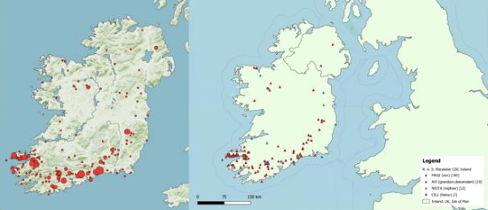
figure 3: left: Ogham stones in Ireland (CC BY 4.0 Katja Hölzl,
RGZM), right: distribution of family relation stones in QGIS (CC BY 4.0
Florian Thiery)
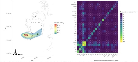
figure 4:l eft: density plot created in R, right:
co-occurrences of words in R (CC BY 4.0 Sophie C. Schmidt)
The
Wikidata SPARQL endpoint enables the query of Ogham stones and their
coordinates, to export the data and visualise the stone frequencies
in third party software (cf. figure 3, l.) Using the SPARQL Unicorn QGIS
Plugin, the Ogham stones can be queried and mapped in GIS software. For
further research, GIS can be used to do geospatial analysis like analyse
the distribution of stone in Ireland by certain family relations. Figure
3, r. indicates that most of the stones mention the word MAQI (son) and
can be found in the province of Munster. Figure 4, l. shows a density
plot of all Ogham Stones created within the programming language R. The
main distribution of stones in the south of Ireland, especially the
peninsula Dingle, is easily recognisable. An analysis of the contents of
Ogham stones, i.e. a linguistic analysis has been done using the
Ogham Extractor
Tool. Usually, this involves an analysis of the texts’ content using
Natural Language Processing methods such as topic modelling (Murakami et
al. 2017) for the purpose of categorising the input of a text. In this
process, statistics about the texts’ contents, e.g. their word
frequencies or sentiment analysis, can be conducted. Usually, a
dictionary of the available text corpus is created using vocabularies
such as the Lexicon Model for Ontologies: Lemon (McCrae, Spohr and
Cimiano 2011) and Ontologies of Linguistic Annotation (OLiA) (Chiarcos
and Sukhareva 2015). The results can be annotated and shared as LOD or
provide the basis for exports in GeoJSON, such as the ones shown in
figure 3, r. As Ogham stones only provide limited text content, a simple
keyword matching was sufficient to match meanings of names and to create
a LOD dictionary out of the whole corpus of Ogham contents for further
analysis in the linguistic or historical communities. Combined with
spatial information, not only a spatial distribution of categorised
names can be shown, but also the linguistic organization of the Ogham
language in terms of words, phrases, characters and their interlinkage
to concepts representing their meaning. As an example, an analysis
showing how often two words co-occur on Ogham stones has been calculated
(cf. figure 4, r.): The information MAQI (son) being supplemented with
MUCOI (tribe) very often, shows the importance of the tribal affiliation
and not just immediate family. On the other hand, it is interesting,
that ANM (name) though occurring relatively often, coincides on only 4
stones together with MAQI.
10 SUMMARY AND OUTLOOK
This paper aimed to answer the questions: Is it possible to step into
Geodesy 3.0 doing SPARQLing geodesy for CH? Can publishing and analysing
volunteered Linked (Geo-)Data in Wikidata preserve information on CH? We
consider it possible and have exemplified a workflow using the Ogi Ogham
Project. Some challenges remain, especially in the geospatial domain.
Publishing strategies and applications for semantic data in order to
integrate LOD in the common workflow are still needed. The SPARQL
Unicorn QGIS Plugin is one step closer to achieving this. If the data is
made accessible in a Geodesy 3.0 approach, this data may be used in AI
and ML projects to reach Geodesy 4.0 to allow an excellent field of work
in the future. In upcoming projects, the working group Research Squirrel
Engineers will apply methods that preserve digital information on CH. We
plan to use Linked Data techniques and the SPARQL unicorn approach to
e.g. publish the rock art carvings in Alta, Norway, (Tansem and Johansen
2008) and make them semantically available. This World Heritage site is
located next to the coast and is beginning to disappear as a result of
erosion and rise in sea level from climate change. On the one hand it
will be
conserved by the VAM and on
the other hand Linked Data will be
created by the Research Squirrel
Engineers to make the carvings available via
Wikidata.
11. ACKNOWLEDGEMENTS
We would like to thank Dr. Kris Lockyear who made the CISP database
available to us. We are also grateful to Toni Marie Goldsmith and Gary
Nobles for the English language corrections.
REFERENCES
- Aghaei, S 2012 Evolution of the
World Wide Web : From Web 1.0 to Web 4.0, International journal of Web &
Semantic Technology, 3(1): 1–10. DOI: https://doi.org/10.5121/ijwest.2012.3101
- Agoub, A, Kunde, F and Kada, M 2016 Potential of Graph Databases in
Representing and Enriching Standardized Geodata. In: 06/2016.
- Association of Research Libraries 2019 ARL White Paper on Wikidata
Opportunities and Recommendations.
- Atemezing, G, Corcho, O, Garijo, D,
Mora, J, Poveda-Villalón, M, Rozas, P, Vila-Suero, D and
Villazón-Terrazas, B 2013 Transforming meteorological data into Linked
Data, Semantic Web, 4(3): 285–290. DOI: https://doi.org/10.3233/SW-120089.
- Battle, R and Kolas, D 2012 Enabling the geospatial Semantic Web with
Parliament and GeoSPARQL, Semantic Web, 3(4): 355–370. DOI:
https://doi.org/10.3233/SW-2012-0065.
- Benedict, K 2005 The Open Geospatial Consortium Web Map, Web Feature and
Web Coverage Service Standards ñ an Overview.
- Bennett, I, Devlin, G and
Harrington, C 2016 CORCA DHUIBHNE 3D, Archaeology Ireland, 30(2): 17–20.
- Berners-Lee, T 2006 Linked Data - Design Issues. 27 July 2006.
- Berners-Lee, T, Hendler, J and Lassila, O 2001 The Semantic Web,
Scientific American, 284(5): 34–43. DOI: https://doi.org/10.1038/scientificamerican0501-34.
- Butler, H, Daly, M, Doyle, A, Gillies, S, Hagen, S and Schaub, T 2016
The GeoJSON Format, Internet Engineering Task Force (IETF).
- Chiarcos, C
and Sukhareva, M 2015 OLiA – Ontologies of Linguistic Annotation,
Hellmann, S., Moran, S., Brümmer, M., and McCrae, J.P. (eds.) Semantic
Web, 6(4): 379–386. DOI: https://doi.org/10.3233/SW-140167.
- Debruyne, C, Meehan, A, Clinton, É, McNerney, L, Nautiyal, A, Lavin, P
and O’Sullivan, D 2017 Ireland?s Authoritative Geospatial Linked Data.
In: d’Amato, C., Fernandez, M., Tamma, V., Lecue, F., Cudré-Mauroux, P.,
Sequeda, J., Lange, C., and Heflin, J. (eds.) The Semantic Web – ISWC
2017. Cham: Springer International Publishing. pp. 66–74. DOI:
https://doi.org/10.1007/978-3-319-68204-4_6.
- Goodwin, J, Dolbear, C and Hart, G 2008 Geographical Linked Data: The
Administrative Geography of Great Britain on the Semantic Web,
Transactions in GIS, 12: 19–30. DOI: https://doi.org/10.1111/j.1467-9671.2008.01133.x.
- Gruber, E 2018 Linked Open Data for Numismatic Library, Archive and
Museum Integration. In: Matsumoto, M. and Uleberg, E. (eds.) CAA2016.
Oceans of Data. Proceedings of the 44th Conference on Computer
Applications and Quantitative Methods in Archaeology. 2018 Oxford:
Archaeopress. pp. 55–62.
- Hahmann, S and Burghardt, D 2010 Connecting
LinkedGeoData and Geonames in the Spatial Semantic Web.
- Hahmann, S and
Burghardt, D 2012 Forschungsergebnisse zur Frage: Haben 80% aller
Informationen einen Raumbezug?, gis.SCIENCE - Die Zeitschrift für
Geoinformatik, 25(3): 101–108.
- Hausenblas, M and Boram Kim, J G 2015
5-star Open Data. 5 ★ OPEN DATA, 31 August 2015.
- Kashyap, R 2019
Geospatial Big Data, Analytics and IoT: Challenges, Applications and
Potential. In: Das, H., Barik, R.K., Dubey, H., and Roy, D.S. (eds.)
Cloud Computing for Geospatial Big Data Analytics. Cham: Springer
International Publishing. pp. 191–213. DOI: https://doi.org/10.1007/978-3-030-03359-0_9.
- Khayari, A and Banzet, G 2019 Alignement d’un thésaurus sur GeoNames :
retour d’expérience.
- Lasi, H, Fettke, P, Kemper, H-G, Feld, T and
Hoffmann, M 2014 Industry 4.0, Business & Information Systems
Engineering, 6(4): 239–242. DOI: https://doi.org/10.1007/s12599-014-0334-4.
- Lockyear, K 2000, The Celtic Inscribed Stones Project Database: a guide.
https://www.ucl.ac.uk/archaeology/cisp/database/manual/ , accessed
2020-01-27.
- Lopes, N, Grant, R, Ó Raghallaigh, B, Ó Carragáin, E,
Collins, S and Decker, S 2014 Linked Logainm: Enhancing Library Metadata
Using Linked Data of Irish Place Names. In: Bolikowski, Ł., Casarosa,
V., Goodale, P., Houssos, N., Manghi, P., and Schirrwagen, J. (eds.)
Theory and Practice of Digital Libraries -- TPDL 2013 Selected
Workshops. Cham: Springer International Publishing. pp. 65–76. DOI:
https://doi.org/10.1007/978-3-319-08425-1_7.
- Macalister, R A S 1945 Corpus inscriptionum insularum Celticarum. Vol.
I. Dublin: Stationery Office.
- Macalister, R A S 1949 Corpus
inscriptionum insularum Celticarum. Vol II. Dublin: Stationery Office.
- MacManus, D 1997 A guide to Ogam. Maynooth monographs 4. Maynooth: An
Sagart.
- McCrae, J, Spohr, D and Cimiano, P 2011 Linking Lexical
Resources and Ontologies on the Semantic Web with Lemon. In: Antoniou,
G., Grobelnik, M., Simperl, E., Parsia, B., Plexousakis, D., De
Leenheer, P., and Pan, J. (eds.) The Semantic Web: Research and
Applications. Berlin, Heidelberg: Springer Berlin Heidelberg. pp.
245–259. DOI:
https://doi.org/10.1007/978-3-642-21034-1_17.
- Mayer, C 2016 Das
OOO-Modell: Open Source - Open Data - Open Access. Wie GIS im Jahre 2016
funktionieren kann.
- Murakami, A, Thompson, P, Hunston, S and Vajn, D
2017 ‘What is this corpus about?’: using topic modelling to explore a
specialised corpus, Corpora, 12(2): 243–277. DOI:
https://doi.org/10.3366/cor.2017.0118.
- Nogueras-Iso, J,
Zarazaga-Soria, F J, Béjar, R, Álvarez, P J and Muro-Medrano, P R 2005
OGC Catalog Services: a key element for the development of Spatial Data
Infrastructures, Computers & Geosciences, 31(2): 199–209. DOI:
https://doi.org/10.1016/j.cageo.2004.05.015.
- Portele, C 2007 OpenGIS® Geography Markup Language (GML) Encoding
Standard. Version 3.2.1.
- Prudhomme, C, Homburg, T, Ponciano, J-J,
Boochs, F, Cruz, C and Roxin, A-M 2019 Interpretation and automatic
integration of geospatial data into the Semantic Web, Computing, 1–27.
- Prud’hommeaux, E and Seaborne, A 2008 SPARQL Query Language for RDF. W3C
Recommendation, 15 January, .
- Pütt, K 2018 Documentation and Digital
Preservation of Syrian Heritage: A German Archive Project for Syria, The
Public Historian, 40(4): 107–128. DOI: https://doi.org/10.1525/tph.2018.40.4.107.
- Sanderson, R 2019 LOUD: Linked Open Usable Data. 28 May 2019.
- Severance,
C 2012 Discovering JavaScript Object Notation, Computer, 45(4): 6–8.
DOI:
https://doi.org/10.1109/MC.2012.132.
- Shadbolt, N, O’Hara, K,
Berners-Lee, T, Gibbins, N, Glaser, H, Hall, W and schraefel, m. c. 2012
Linked Open Government Data: Lessons from Data.gov.uk, IEEE Intelligent
Systems, 27(3): 16–24. DOI: https://doi.org/10.1109/MIS.2012.23.
- Simon, R, Isaksen, L, Barker, E and de Soto Cañamares, P 2016 The
Pleiades Gazetteer and the Pelagios Project. In: Berman, M.L., Mostern,
R., and Southall, H. (eds.) Placing names: enriching and integrating
gazetteers. The spatial humanities. Bloomington: Indiana University
Press. pp. 97–109.
- Stadler, C, Lehmann, J, Höffner, K and Auer, S 2012
LinkedGeoData: A core for a web of spatial open data, Semantic Web,
3(4): 333–354. DOI: https://doi.org/10.3233/SW-2011-0052.
- Tansem, K and Johansen, H 2008 The World Heritage Rock Art in Alta
2008(Adoranten 2008): 1–20.
- Thiery, F 2020 Ogham Words DOI:
https://doi.org/10.5281/zenodo.3611029.
- Thiery, F and Schmidt, S C 2020a Ogham Stones Wikidata Import DOI:
https://doi.org/10.5281/zenodo.3612654.
- Thiery, F and Schmidt, S C 2020b Ogham Townlands Wikidata Import DOI:
https://doi.org/10.5281/zenodo.3612649.
- Thiery, F, Trognitz, M, Gruber, E and Wigg-Wolf, D 2019 Hic sunt
dracones! the modern unknown Data Dragons DOI: https://doi.org/10.5281/zenodo.3345711.
- Trognitz, M and Thiery, F 2019 Wikidata - A SPARQL(ing) Unicorn? DOI:
https://doi.org/10.5281/zenodo.3471404.
Vrandečić, D and Krötzsch, M 2014 Wikidata: a free collaborative
knowledgebase, Communications of the ACM, 57(10): 78–85. DOI:
https://doi.org/10.1145/2629489.
- Vretanos, P 2005 Web Feature Service Implementation Specification,
Version 1.1.0.
- Wahlster, W 2017 Artificial Intelligence as the driver of
the second wave of digitalization. 26 September 2017.
- Wenjue, J, Yumin,
C and Jianya, G 2004 Implementation of OGC web map service based on web
service, Geo-spatial Information Science, 7(2): 148–152. DOI:
https://doi.org/10.1007/BF02826653.
- Wilkinson, M D, Dumontier, M,
Aalbersberg, Ij J, Appleton, G, Axton, M, Baak, A, Blomberg, N, Boiten,
J-W, da Silva Santos, L B, Bourne, P E, Bouwman, J, Brookes, A J, Clark,
T, Crosas, M, Dillo, I, Dumon, O, Edmunds, S, Evelo, C T, Finkers, R,
Gonzalez-Beltran, A, Gray, A J G, Groth, P, Goble, C, Grethe, J S,
Heringa, J, ’t Hoen, P A ., Hooft, R, Kuhn, T, Kok, R, Kok, J, Lusher, S
J, Martone, M E, Mons, A, Packer, A L, Persson, B, Rocca-Serra, P, Roos,
M, van Schaik, R, Sansone, S-A, Schultes, E, Sengstag, T, Slater, T,
Strawn, G, Swertz, M A, Thompson, M, van der Lei, J, van Mulligen, E,
Velterop, J, Waagmeester, A, Wittenburg, P, Wolstencroft, K, Zhao, J and
Mons, B 2016 The FAIR Guiding Principles for scientific data management
and stewardship, Scientific Data, 3: 160018.
- Wuttke, U 2019 “Here be
dragons”: Open Access to Research Data in the Humanities. ulrikewuttke.
- Würriehausen, F, Homburg, T and Müller, H 2016 Using an INSPIRE Ontology
to Support Spatial Data Interoperability, INSPIRE 2016, Barcelona,
Spain.
BIOGRAPHICAL NOTES
Florian Thiery is a geodesist and Research
Software Engineer working in the Cultural Heritage domain. He is a
member of the DVW working group 1 “Profession/Education” as well as of
the Scientific Committee of the Computer Applications and Quantitative
Methods in Archaeology (CAA). Sophie Charlotte Schmidt is a
computational archaeologist specialised in statistical data analysis
using R. Mrs. Schmidt is a member of the advisory board of the German
speaking CAA chapter. Timo Homburg studied Computer Science with
emphasis on Computational Linguistics, Semantic Web and Chinese studies
and in the last years worked in the GIS field to integrate geospatial
data with Semantic Web technologies. His PhD thesis deals with semantic
geospatial data integration and the quality of geospatial data in this
Semantic Web context. Martina Trognitz studied Computational Linguistics
and Classical Archaeology at the University of Heidelberg and is
currently working on a PhD. Mrs. Trognitz is a member of the advisory
board of the German speaking CAA chapter. Monika Przybilla holds a
university degree in geodesy and has long term activities in the DVW
working group 1 “Profession/Education”, chair since 2015.
CONTACTS
Florian Thiery M.Sc.
Research Squirrel Engineers, Mainz
Josef-Traxel-Weg
4
D – 55128 Mainz
Germany
Web site: http://fthiery.de
Timo Homburg M.Sc.
Institute for Spatial Information and Surveying Technology, Mainz,
Germany
Sophie Schmidt M.A. University of Cologne, Institute of Archaeology,
Cologne, Germany
Mag. Martina Trognitz Austrian Centre for Digital Humanities and
Cultural Heritage, Vienna, Austria
Dipl.-Ing. Monika Przybilla Regionalverband Ruhr, Essen, Germany


