Article of the Month -
October 2010
|
Reducing Vulnerability to Natural Disasters in the Asia
Pacific through Improved Land Administration and Management
David MITCHELL, Australia
 This article in .pdf-format
(12 pages, 98 KB)
This article in .pdf-format
(12 pages, 98 KB)
1) This paper is a peer reviewed paper prepared
for the FIG Congress 2010 in Sydney, Australia, 11-16 April 2010. At the
Congress it was presented in a session about Spatial Information for
Climate Change Monitoring and Other Natural Disasters Management
and draws on the lessons from recent major disasters and existing
literature on land issues.
Handouts of this presentation as a .pdf file.
Key words: climate change, natural disasters, tenure security,
disaster resilience, vulnerability.
SUMMARY
There is evidence linking climate change with an increase in the
frequency, severity, and unpredictability of natural disasters in the
past decade. Between 1974 and 2003 there were 6,367 such destructive
natural disasters, resulting in over 2 million deaths, with 75% of these
in Asia alone (Guha-Sapir et al, 2004). Lessons from the 2004 Asian
tsunami, recent earthquakes in India and Indonesia, and tropical
cyclones in the Philippines and Samoa have highlighted the significant
land issues that can arise in the aftermath of the natural disaster.
This includes people losing access to land through resettlement, and
land grabbing causing loss of connection with pre-disaster sources of
livelihood. Since the Asian tsunami there has been extensive analysis of
the approaches taken to address these land issues after natural
disasters, and the literature contains several case studies and
comprehensive reports from international agencies providing guidelines
for addressing land issues after natural disasters.
This paper concentrates on issues in developing countries in the Asia
Pacific and draws on the lessons from recent major disasters and also
existing literature on land issues. Coastal communities are often at
greatest risk of these events and it is often the poor sections of the
community who occupy land at greatest risk. The paper also refers to the
links between community vulnerability and tenure security.
1. INTRODUCTION
There is evidence linking climate change with an increase in the
frequency, severity, and unpredictability of natural disasters in the
past decade. Between 1974 and 2003 there were 6,367 such destructive
natural disasters, resulting in over 2 million deaths (Guha-Sapir et al,
2004). The Asia Pacific region includes the volcanic ring of fire in the
Pacific and the cyclone and storm paths of East Asia. An analysis of the
data on natural disasters in EM-DAT reveals that more than 75% of the
total number of people killed by natural disasters between 1994 and 2003
were in Asia (Guha-Sapir et al, 2004). Losses causes by natural
disasters are greater in developing countries in Asia and the Pacific,
and the poor are particularly vulnerable. While the 2004 Asian tsunami
received much press, disasters such as earthquakes, tropical cyclones,
avalanches, landslides and floods are also common in many countries in
the region.
Natural disasters such as these cause damage to land and loss of
access to land often results in loss of shelter and livelihoods,
sometimes permanently. During the response to the natural disaster there
are many tensions and difficulties relating to the relocation of
affected communities, the placement of refugee camps, and measures to
increase future resilience through avoiding reconstruction on land at
risk of further hazards. Vulnerability to disasters is dependent of
several factors including the degree of exposure to sites at risk of
disaster, social factors such as the level of conflict and
discrimination, the strength of the economy, and the level of
environmental degradation. Among these vulnerability factors is the
level of tenure security for landholders and this will be discussed
throughout this paper.
One of the lessons from recent natural disasters is that the poorest
and politically weakest members of society are the most vulnerable to
the impacts of natural disasters. This was the case in the aftermath of
the 2004 Asian tsunami with poor landholders most vulnerable to being
displaced from their land. In Aceh disputes over land arose, caused by
opportunistic land grabbers, and uncertain inheritance rights where the
parents had perished (6,000 inheritance cases were filed in the first
three months). Also where building foundations were deeply buried and no
traces of land parcel boundaries existed, restoring property rights was
even more complex (BRR and the World Bank, 2005). There was also the
question of whether reconstruction should occur in hazard prone areas.
In Thailand the security of tenure was put under even more pressure in
tsunami-affected areas within tourist destinations, and areas with high
property values. Handmer et al (2007) reported on the displacement of
many local people along the Andaman coastline in Thailand following the
Asian tsunami, and the incidence of tourism land developers taking
control of these areas. They reported that local people were unable to
prove formal title over land due to lack of formal tenure or loss of
land title documents. This opened up the opportunity for land
developers. This is evidence of a breakdown in governance impacting on
the land rights of these individuals.
Work commissioned by UN-HABITAT and UN-FAO has resulted in several
case studies of the land issues following natural disasters including
earthquakes in India, the Philippines and Indonesia; the 2004 Asian
tsunami, tropical cyclones and floods in Bangladesh and the Philippines;
and mudflows and landslides in the Philippines. This work has led
towards, among other initiatives, the preparation of a set of guidelines
on addressing land issues after natural disasters (Fitzpatrick, 2008).
Whilst the nature of the land issues differs depending on the type of
natural disaster and the situation of the country, some common lessons
can be drawn from this literature.
Natural disasters often involve temporary resettlement of large
numbers of people and the choice of location should be chosen in
consultation with the community, and where possible, be within reach of
pre-disaster livelihoods. The risks are that people will be resettled in
unsuitable areas and return to affected lands too early, or that
conflict will result within the resettlement areas. Principle 2 of the
Pinheiro Principles (Inter-Agency, 2007) involves the right to housing
and property restitution for refugees and displaced persons, and states
that all displaced persons have the right to have restored to them any
housing, land and/or property of which they were arbitrarily deprived,
or to be compensated where it is factually impossible to restore as
determined by an independent, impartial tribunal. In the event of a
catastrophe this is a challenge for the central government, especially
in developing countries, as the cost of compensation may be very high.
Resettlement should not be on land where others have claims unless by
agreement with a host community, or on government land. Also,
recognition of land rights is important during resettlement and also for
subsequent restitution, otherwise people fear eviction.
Disasters usually result in high levels of loss of access to
productive land, loss of crops and livelihoods. Some people may be
forced to sell their land and others may not be able to meet their
sharecropping or lease agreements. These pressures can lead to land
conflicts. Natural disasters also have a significant impact on the
capacity of land administration systems through loss of staff, damage to
boundary markers and survey marks, damage to land records and land
offices. In most countries in the region the land administration system
is weak in any case and the impact of the disaster further weakens the
capacity of the land agencies. Soon after the 2004 Asian tsunami, the
Indonesian Land Agency (BPN) issued a decree preventing the selling of
land in an effort to stop land speculation, and while it is hard to
judge the degree of informal land transactions that may have occurred,
there were not widespread reports of land grabbing.
Existing tenure security issues and problems are highlighted after
disasters, and the recovery and reconstruction phase is an opportunity
to assess these. Disasters affect urban and rural lands and invariably a
range of tenures and forms of access rights to land. Often the landless
(labourers and sharecroppers, etc) and people with insecure tenure are
the most vulnerable to disasters. There is a need to quickly assess
previous formal, and informal land rights that existed prior to the
disaster, and these often vary in legal and social legitimacy. In some
cases long established customary rights exist without legal recognition.
Recognition of informal tenure and partial rights such as squatters, or
sharecroppers, or renters is necessary but more difficult to adjudicate.
So, a flexible approach to adjudicating and validating land tenure is
needed.
There is an urgent need for adjudication of rights, prior to
construction, to determine eligibility for assistance for rebuilding or
reconstruction. However, the sheer scale of the challenge facing those
responsible for the emergency response is often enormous. During the
emergency response and subsequent recovery a trade-off is needed between
rebuilding homes as quickly as possible, and undertaking a transparent
and community driven process. Often the land records needed to make
decisions on pre-disaster rights to land are either out of date or have
been destroyed. Also, a loss of personal records and formal government
land records complicates the adjudication process. Therefore decisions
on the adjudication of rights to land should be made in close
consultation with the community and where possible be based on
consensus.
The lessons from recent natural disasters provide an opportunity to
consider what actions communities at risk of natural disasters can take
to reduce their vulnerability to natural disasters and increase their
resilience in the event of a natural disaster. This is of particular
importance to the poorer coastal communities in the Asia and Pacific
region as the potential for rising sea levels and more frequent storm
events increases their vulnerability. Natural hazards such as tidal
surges, landslides, floods, cyclones, hurricanes and volcanic eruptions
can affect communities on a recurrent basis. The urban poor in coastal
communities are often at greatest risk of these recurrent events and it
is often the poorer sections of the community who settle in hazard prone
areas. In many cases the land they occupy is not subject to building
controls and settlements development with informal dwellings and no
legal recognition of their land tenure (Quan and Dyer, 2008).
2. LAND TENURE AND DISASTER RISK MANAGEMENT
Secure land tenure provides a degree of economic security for the
landholder and, assuming appropriate governance, provides protection
against other interests. In a seminal World Bank publication on property
rights, Deininger (2003) stated that “tenure security depends on a host
of objective and subjective factors, including the clarity with which
rights and obligations are defined; the quality and validity of property
rights records and whether or not the state guarantees them; the
precision with which boundaries are demarcated; the likelihood that
rights will be violated; the ability to obtain redress by an
authoritative institution in such cases, along with the reassurance that
whatever measures the institution decides are deemed appropriate and can
be enforced effectively. Deficiencies in any of these areas, or a
mismatch between different components of the property rights system, can
seriously undermine tenure security, thereby increasing the potential
for conflict and undermining the incentives for investment and change”.
Over the last 15 years various countries in the Asia and Pacific region
have implemented land administration projects that involve the creation
and registration of land titles. The objectives of many of these land
administration projects have been to improve tenure security and access
to land, potentially resulting in more efficient agricultural production
and improved livelihoods, improved governance and equity (Mitchell et
al, 2007).
However, many countries in the Asia Pacific region do not have a
formalised land tenure system and rely on customary arrangements, and
other types of informal tenure. Whilst such arrangements might have been
suitable in traditional and historical circumstances, pressures on land
tenure due to climate change will result in an altogether different
reality. Even in countries with land titling programs, much of the
occupied land remains under state control, or lies outside the scope of
the titling project.
Land that is agriculturally marginal, or hazard-prone, tends to have
no formal land tenure in place and the occupiers have settled there
because they don’t have claim to any other land. They typically have
very poor infrastructure and limited government support. In hazard-prone
areas this presents a problem as they are at high risk of the impact of
a natural disaster and also very vulnerable to loss of access to land
and the livelihoods they derive from the land or associated water
resources. Natural hazards such as floods may only affect a community or
agricultural land every few years, but the damage can be significant.
Landholders need to find ways to live with the threat of the disaster,
respond when the disaster occurs, and to rebuild their homes and
livelihoods after the event.
Tran et al (2007) argued that the Vietnamese people are very used to
living with severe floods and this is embedded in their culture.
Accordingly they have had a large system of river and coastal dykes in
place to control flooding for centuries, and this has worked on most
occasions. However, they add that “this structural approach to flood
control is now under pressure because the conditions inducing flooding
are intensifying, both at the local and global level…For example,
population increase, rapid urbanization, high demand for natural
resource exploitation, environmental pollution, and degradation are
coupled with global threats, such as climate change”. This theme is
continued by Satterthwaite et al (2007) who argue that in addition to
government adaptive response, the urban poor demonstrate a significant
capacity to undertake measures such as building shelters and drainage
channels to protect themselves and their properties from flood risks.
This was the experience also in Aceh where Fitzpatrick and Zevenbergen
(2007) reported that “coastal communities proved remarkably resilient
after the tsunami…community-based methods and approaches proved the most
successful in fostering sustainable and largely conflict-free recovery”.
However, Quan and Dyer (2008) argued that “Such autonomous
adaptations are however constrained by insecure land tenure which
creates disincentives for people to invest scarce resources in risk
reduction. For both new and existing settlements more secure land tenure
is required so as to improve resilience to sea level rise related risks
by promoting investments in better housing and community
infrastructure”.
Analysis of recent natural disasters has provided lessons for future
Disaster and Risk Management (DRM). Figure 1 provides an overview of the
post-disaster processes in a typical DRM framework that includes
recovery, risk assessment, prevention, mitigation and preparedness. Each
of these stages provides opportunities for improvements to land
administration and management that lay the basis for reduced
vulnerability.
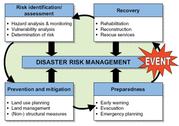
Figure 1. Key Elements of Disaster Risk Management (Source: FIG
(2006))
Responses to natural disasters need to consider land issues in the
preparation for early recovery. Secure land tenure is important in
responding to natural disasters in terms of allocating assistance and
retribution in reinstating homes and livelihoods. However, if land
tenure is unclear or uncertain, post-determination will be difficult and
may exacerbate the negative impact of the weather event and undermine
community cohesion and peace-building. There is also often an inevitable
need to relocate people due to changed conditions following the natural
disaster. This was the case in Aceh following the tsunami. A sudden
tectonic plate movement in Sumatra caused the tsunami and also pushed
down the coastal shelf along much southern Aceh, especially around
Singkil (BRR and the World Bank, 2005). The result was that many areas
are now 1.5 meters lower than prior to the tsunami and much of the
previously occupied land is flooded every high tide. This inevitably led
to decisions on where people should be relocated and the likely impact
on their livelihoods.
Lessons from responses to the Asian Tsunami indicate that tenure will
be secure in natural disaster responses where there is adequate land
administration data or the land records received little damage,
landholders have documentary evidence of legal rights to land, the land
administration system is responsive and flexible, and the governance
arrangements of land administration agencies allow for fast and
transparent processes for claims to land and inheritance. The question
of whether or not to rebuild in hazard-prone areas is also significant.
In addition, proof of ownership brings the possibility of using the land
as collateral for investments in disaster recovery actions. In face of
these challenges, the strength and cohesiveness of the local community
as very significant in the protection of property rights in the event of
a natural disaster.
3. REDUCING THE VULNERABILITY OF COMMUNITIES TO LOSS OF LAND
Following the recovery phase following a disaster there are
opportunities to reflect on the land issues that have arisen and develop
risk reduction measures what will reduce the vulnerability of those at
risk. Formal recognition by government of all valid forms of existing
tenure is paramount. Disaster mitigation should therefore include an
assessment of the security of tenure in areas at risk of natural
disasters and the communication of the results to the community. In
particular, the rights of women and children and disadvantaged social
groups should be identified. This would place landholders in a stronger
position to negotiate in the event of a natural disaster.
The first part of this opportunity is improving the capacity of the
land administration to cope with future events. The developing countries
in the Asia Pacific region are quite diverse in land tenure systems and
governance arrangements, which makes it hard to generalise. However,
there are large areas of customary land in many of these countries. On
private land informal arrangements are more common than land titles. In
most of these countries there are problems with the capacity of the land
administration system that exacerbate the challenges in the event of a
natural disaster.
An improvement to the capacity of land offices in areas at highest
risk of natural disasters is important in reducing vulnerability for
those with land titles. Capacity building of land institutions is
central to improved governance as many existing institutions do
currently have the capacity to implement the DRM measures required. This
capacity building could take the form of training staff in the land
issues that arise after disasters, developing an inventory of informal
rights to land, and taking steps to protect the land records and survey
infrastructure from the impact of a natural hazard. With improved
capacity in the land administration agencies comes an opportunity for
land experts to be more involved in the improvement to tenure security.
The land management paradigm outlined by Enemark (2004), describes
land management as the components of land administration as land tenure,
land valuation, and land use management, supported by a land policy
framework and land information infrastructure (See Figure 2).
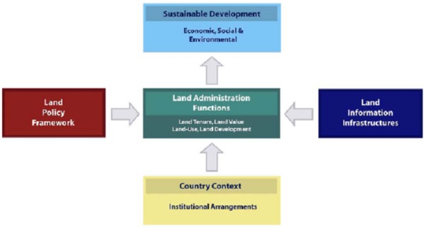
Figure 2. The Land Management Paradigm (Source: Enemark, 2004)
The most significant long-term impact that land administration can
have on vulnerability is the improvement of tenure security for those
without legally recognised rights to land. This applies to both
privately occupied land and to collectively managed land. Brown and
Crawford (2006) presented the results of a survey of humanitarian and
development professionals, commentators and academics involved with
disaster management and mitigation. They reported that the respondents
agreed that clarity over private and communal land ownership was
critical to the effective reconstruction of disaster-affected regions.
This clarity allowed them to provide secure credit for reconstruction,
and allowed them to benefit from any compensation packages that may be
offered. However, improving tenure security is by nature a complex and
long-term process and it is widely considered that improvements to
tenure security should be incremental and progress up a ‘ladder of
rights’ (GLTN 2008, Barnes and Riverstone 2009). The development of an
updated land policy framework is the appropriate way to commence the
process of improving tenure security. Lessons from previous disasters
should be catalogued and used as a basis for the development of land
policies that consider land tenure issues in hazard-prone areas, using a
participatory and transparent process. Previous experience suggests that
the success of implementation of land policies will inevitably be depend
on a range of factors including governance, political will, and the
degree of public involvement in the development of the policies.
Closely related to improvements to tenure security is the necessity
to educate the public about their rights to land, so that they are less
likely to be taken advantage of in the event of a disaster. Part of this
responsibility lies with the land agencies to undertake community
education programs about land polices and laws and their rights within
these.
Improvements to land valuation also are important to reducing
vulnerability to inadequate compensation where loss of land occurs
following a natural disaster. Approaches to DRM can also make allowances
for compensation payments in the event of a disaster. Developing
up-to-date land valuation maps and records will provide a basis for
discussion of compensation. Information of this type places the
landholders in a stronger bargaining position with government when
compensation is discussed.
Land use management (or physical planning) also has a role to play in
reducing vulnerability. Land use master plans that consider the risk of
settlement in hazard-prone areas are important. Decisions on
resettlement should be made in consultation with land experts and in
high-risk areas the choice of potential resettlement sites in the event
of a disaster could be made in consultation with the public prior to the
occurrence of a natural hazard. In extreme cases there may be a need to
consider whether some people should be permanently resettled to areas
with less risk. However, there are many potential problems with this
approach and decisions need to be made in close consultation with the
landholders otherwise they risk loss of tenure security, loss of access
to previous livelihoods and social fragmentation. For example, after the
2004 Asian tsunami the Sri Lankan government created coastal zones of
between 100m and 300m preventing housing construction in tsunami
affected areas an effort to avoid a repeat of the devastation. This
would have resulted in the relocation of many thousands of people and
risk increasing tensions between resettled and existing communities
(Brown and Crawford, 2006). These restrictions were eventually relaxed.
The Hyogo Framework for Action (ISDR, 2005) calls for, among many
recommendations, for disaster risk assessments to be incorporated into
urban planning and management in disaster-prone settlement areas. This
is endorsed by Enemark (2009, p12) who states that “Integration of all
aspects of the disaster risk management circle…into the overall land
administration system will enable a holistic approach that should
underpin the general awareness of the need for being prepared for
natural disasters and also being able to manage actual disaster events”.
The respondents in the survey by Brown and Crawford (2006) believed that
poor land-use planning increased disaster vulnerability through delays
to reconstruction, and increased tensions between those competing for
scarce resources. In the absence of cohesive land use planning prior to
a natural disaster one of the issues that invariably comes up during
reconstruction efforts is whether humanitarian and development
organizations should take advantage of the significant severance between
people and their landholdings to implement more sustainable land
ownership systems moving forward.
In the absence of climate change recognition in land policy
spontaneous adaptations will occur. The lessons for adaptive planning
and climate change mitigation are in the consideration of the
implications of climate change on existing land tenure and land use
arrangements, the likely impact on tenure systems of mitigation
measures, and how climate change can be incorporated into land policies.
Quan and Dyer (2008) argued that:
“The progressive ingredients of urban land policies to upgrade
informal settlements, improve tenure security, increase delivery of
appropriate land through public-private collaboration, simplify and
strengthen planning arrangements, and extend popular participation
therefore all have a significant role to play by improving the
incentives and flexibility for individuals, small businesses and
communities to adapt to the risks of sea level rise”.
By bringing land administration and physical planning closer
together, and supported with disaster risk information better decisions
on land tenure and land use are possible, and the poorest will benefit.
4. CONCLUSIONS
There is growing evidence that climate change will lead to an
increase in the incidence of natural disasters. The likelihood is that
recurrent events such as tidal surges, cyclones, and floods will become
a greater problem for some communities. Unfortunately the people most
vulnerable are often the poorest section of the community, and often
live in areas with informal tenure. Security of tenure is an important
factor in the reconstruction and restitution after a natural disaster
and should therefore be considered as an element of the vulnerability of
communities to natural disasters. Improved tenure security strengthens
the negotiation powers of the poor, and can reduce the likelihood of
land grabbing, assist in reconstruction efforts and help with access to
collateral for financing reconstruction. Education of individual’s
property rights and level of tenure security is also important.
Land administration and management can reduce the vulnerability of
people to natural disasters through improved capacity to make decision
on land, the development of land policies that includes the lessons
learned from previous disasters, the development of land valuation
records in at-risk areas, and the development of sound land use master
plans that consider risk areas and resettlement options in consultation
with the community.
ACKNOWLEDGEMENTS
The author wishes to thank his colleagues in the School of
Mathematical and Geospatial Sciences for their input and support.
REFERENCES
- Badan Rehabilitasi dan Rekonstruksi (BRR) and the World Bank,
2005, Rebuilding a Better Aceh and Nias: Stocktaking of the
Reconstruction Effort - Brief for the Coordination Forum Aceh and
Nias (CFAN). For the people of Aceh and Nias, October 2005.
- Barnes, G. and G. Riverstone, 2009, Exploring Vulnerability and
Resilience in Land Tenure Systems after Hurricanes Mitch and Ivan.
Accessed 12/12/09.
www.sfrc.ufl.edu/geomatics/courses/SUR6427/Barnes-riverstone-pap.doc
- Brown, O., and Crawford, A., 2006, Addressing Land Ownership
after Natural Disasters: An Agency Survey, International Institute
for Sustainable Development (IISD), Winnipeg, Canada.
Deininger, K., 2003, Land Polices for Growth and Poverty Reduction,
A World Bank Policy Research Report, World Bank and Oxford
University Press.
- Enemark, S., 2004, Building Land Information Policies,
Proceddings of the Special Forum on Building Land Information
Policies in the Americas, Aguascalientes, mexico, 26-27 October
2004,
www.fig.net/pub/mexico/papers_eng/ts2_enemark_eng.pdf
- Enemark, S., 2009, Sustainable Land Administration
Infrastructures to support Natural Disaster Prevention and
Management, UNESC, Ninth United Nations Regional Cartographic
Conference for the Americas, New York, 10-14 August 2009.
- FIG (2006): The Contribution of the Surveying Profession to
Disaster Risk Management. FIG Publication No. 38. FIG Office,
Copenhagen, Denmark.
http://www.fig.net/pub/figpub/pub38/figpub38.htm
- Fitzpatrick, D., and Zevenbergen, J., 2007, Addressing Land
Issues after Natural Disasters: A Study of the Tsunami Disaster in
Aceh, Indonesia: Draft.
- Fitzpatrick, D., 2008, Guidelines on Addressing Land Issues
after Natural Disasters: EGM Draft 21-23 April 2008, UN-HABITAT/UN
FAO/UNDP.
- Global Land Tools Network, 2008, Secure Land Rights for All.
Nairobi, UN-HABITAT.
Guha-Sapir, D., Hargitt, D., and Hoyois, G., 2004, Thirty years of
natural Disasters 1974 – 2003: The Numbers, Centre for Research on
the Epidemiology of Disasters,
http://www.unisdr.org/eng/library/Literature/8761.pdf, Accessed
22/09/2009.
- Handmer, J. And Choong, W., 2006, Disaster resilience through
local economic activity in Phuket, The Australian Journal of
Emergency Management, Vol. 21 No. 4, November 2006.
- Inter-Agency, 2007, Handbook on Housing and Property Restitution
for Refugees and Displaced Persons: Implementing the 'Pinheiro
Principles'. Turin, FAO/iDMC/OCHA/OHCHR/UN-HABITAT/UNHCR.
- ISDR, 2005, Hyogo Framework for Action 2005-2015: Building the
Resilience of Nations and Communities to Disasters. World Conference
for Disaster Reduction, Kobe, Hyogo, Japan.
Mitchell, D., Clarke, M., and Baxter, J., 2008, Evaluating Land
Administration Projects in Developing Countries, Land Use Policy,
25(4) pp. 464-473.
- Quan, J., and Dyer, N., 2008, Climate Change and Land Tenure:
The implications of Climate Change for Land Tenure and Land Policy,
IIED, UN FAO Land Tenure Working Paper 2,
ftp://ftp.fao.org/docrep/fao/011/aj332e/aj332e00.pdf, Accessed
03/08/2009.
- Satterthwaite D., Huq, S., Pelling M., Reid H., Lankao P.R.
(2007) Adapting to Climate Change in Urban Areas: The possibilities
and constraints in low- and middle-income nations, Human Settlements
Discussion Paper Series, IIED available at
http://www.iied.org/pubs/pdfs/10549IIED.pdf, Accessed
21/09/2009.
- Tran, P., Marincioni, F., Shaw, R., Sarti M., and An, L., 2007,
Flood risk management in Central Viet Nam: challenges and
potentials, Natural Hazards, Volume 46, Number 1 / July, 2008.
BIOGRAPHICAL NOTES
David Mitchell is a licensed cadastral surveyor and worked in
private practice for 12 years before joining RMIT University, where he
has been for 12 years. He is the Australian delegate to FIG Commission
7. David is an international land administration consultant and
undertakes research at RMIT University focusing on the development of
effective land policy and land administration to support tenure
security, improved access to land and pro-poor rural development.
CONTACTS
Dr. David Mitchell
School of Mathematical and Geospatial Sciences,
SET Portfolio, RMIT University
GPO Box 2476V
Melbourne
AUSTRALIA
Tel. + 61 3 9925 2420
Fax + 61 3 9663 2517
Email: d.mitchell@rmit.edu.au
Web site: http://www.gs.rmit.edu.au
 |