Geodetic Infrastructure and Positioning for the Fehmarnbelt Fixed Link
Anna B. O. JENSEN, Denmark, and Anders ALMHOLT,
Denmark
1) This paper describes the
solutions and implementations chosen in establishing a geodetic basis,
or geodetic infrastructure, for the construction work of the Fehmarnbelt
Fixed Link; a tunnel which is being constructed between Germany and
Denmark across the Fehmarnbelt.
SUMMARY
The Fehmarnbelt Fixed Link is a tunnel which is being constructed
between Germany and Denmark across the Fehmarnbelt and is one of the
larger construction projects in Europe at the moment. For such a large
construction project a homogeneous and robust geodetic infrastructure is
important. This paper describes the solutions and implementations chosen
in establishing a geodetic basis, or geodetic infrastructure, for the
construction work.
The geodetic infrastructure consists of establishment of new
permanent GNSS stations, selection of geodetic reference system,
establishment of a geodetic reference frame, determination of mean sea
level in the area, definition of new height system, determination of a
geoid model, derivation of parameters for coordinate transformations to
national reference frames in Germany and Denmark, definition of a map
projection, and development of a transformation software. Finally, a
network based GNSS RTK service has been established based on the
geodetic infrastructure. The GNSS RTK service is used for precise
positioning and navigation within the construction area. The paper
describes the geodetic infrastructure and establishment and testing of
the RTK service.
SUMMARY
Den faste forbindelse over Fehmarnbelt er en sænketunnel, som bliver
bygget mellem Tyskland og Danmark over Fehmarnbelt, og er et af de
større anlægsprojekter i Europa i øjeblikket. Ved så store
anlægsprojekter er et homogent og robust geodætisk grundlag vigtigt.
Denne artikel beskriver de løsninger og implementeringer som er valgt i
forbindelse med etableringen af det geodætiske grundlag, eller den
geodætiske infrastruktur, til anlægsarbejdet med den faste forbindelse.
Etableringen af den geodætiske infrastruktur indebærer etablering af
nye permanente GNSS-stationer, valg af et geodætisk referencesystem,
etablering af en geodætisk referenceramme, bestemmelse af
middelvandstanden i området, fastlæggelse af et nyt højdesystem,
beregning af en geoide model, udledning af koordinattransformationer til
de nationale referencerammer i Tyskland og Danmark, definition af en
kortprojektion og udvikling af et transformations-program. Endelig er
der etableret en netværksbaseret GNSS RTK tjeneste på grundlag af den
geodætiske infrastruktur. RTK servicen bruges til præcis
positionsbestemmelse og navigation i anlægsområdet. Artiklen beskriver
den geodætiske infrastruktur samt etablering og test af RTK servicen.
1. INTRODUCTION
For large construction projects a homogeneous and robust geodetic
infrastructure is important. A geodetic reference frame, a height
system, a geoid model and a map projection is always needed for
construction work. For large projects, the geodetic infrastructure may
be defined and established especially for the project to ensure
consistency and to avoid coordinate transformations, large distance or
direction corrections etc.
This paper describes how the challenge of establishing a new geodetic
infrastructure for a large construction project across the border
between Germany and Denmark has been handled. The work is challenging
because the construction site lies in a border area where reference
frames, height systems and geoid model in the two countries are not
identical. Further, most of the construction site is offshore in the
Fehmarnbelt between Germany and Denmark. The region is illustrated in
Figure 1, with the construction area located in between the GNSS
stations FEH1-4. The distance across Fehmarnbelt is here approximately
18 km.
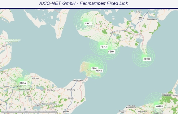
Figure 1. Eight permanent GNSS stations provide data for the RTK service
established in the area. Station locations marked with green circles.
Illustration: AXIO-NET GmbH.
Coordination of the work is important when many organisations and
people are involved. It is important that the work is correctly
sequenced to eliminate or minimize the time lost between the various
tasks. For this construction project it has also been important to make
sure the geodetic infrastructure was available for the last parts of the
pre-investigations and for finalizing the plan approval material.
Therefore establishment of the geodetic infrastructure was initiated as
one of the very first tasks in the pre-investigation phase.
With this paper we describe the solutions and implementations chosen,
starting with the establishment of new permanent GNSS stations,
selection of geodetic reference system, establishment of geodetic
reference frame, definition of new height system, determination of a
geoid model, derivation of parameters for coordinate transformations to
national reference frames, definition of map projection, and last but
not least the establishment of a GNSS RTK service for precise
positioning within the construction area. First, however the
construction project is introduced in the next section.
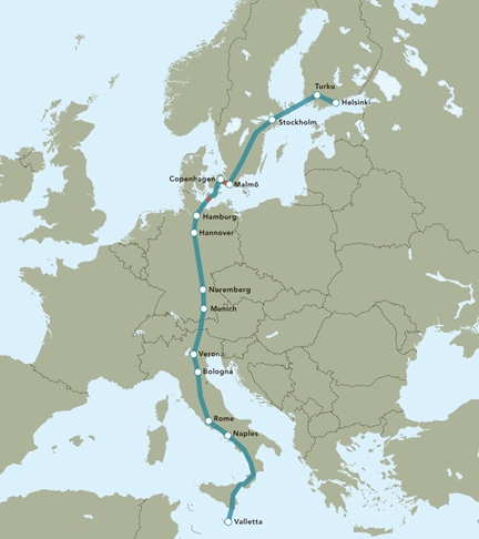
Figure 2. The Scandinavia-Mediterranean corridor. Location of the
Fehmarnbelt Fixed Link is marked in red between Copenhagen and Hamburg.
Illustration: Femern A/S.
1.1 Fehmarnbelt Fixed Link
The Fehmarnbelt Fixed Link realises the dream of a fixed, closed and
direct connection between Scandinavia and continental Europe. This will
considerably reduce the travel time between Scandinavia and continental
Europe.
The Fehmarnbelt Fixed Link is part of the Scandinavia-Mediterranean
corridor, which is a north-south route that will run from the
Finnish-Russian border to Valetta in Malta (Figure 2). The corridor is
considered to be important for the European economy and will tie
Europe's growth centres together from north to south.
The fixed link across Fehmarnbelt will be established between
Puttgarden on the German island of Fehmarn and Rødbyhavn on the Danish
island of Lolland.
The Fehmarnbelt Fixed Link will be established as an immersed tunnel.
It will be placed in a trench excavated on the sea floor, and covered
with a layer of stones. The tunnel will be 18 km long and include both
highway and railway lines. Planning and construction of the tunnel is
managed by the company Femern A/S which is owned by the Danish Ministry
of Transport.
At the time of writing, geotechnical and environmental investigations
are completed. Project plans have been submitted to the German and
Danish authorities for approval, and the tendering process for the major
construction work is ongoing.
2. GEODETIC INFRASTRUCTURE
The geodetic infrastructure for the Fehmarnbelt Fixed Link comprises
a 3D reference frame, a height system and a geoid model for deriving
heights, a map projection for plane maps and drawings, and coordinate
transformation parameters in order to connect to the national reference
frames of Germany and Denmark.
2.1 Permanent GNSS stations
The geodetic reference frame for the Fehmarnbelt Fixed Link is based
on four permanent GNSS stations established for the purpose. The GNSS
stations were established around Fehmarnbelt and to obtain the most
suitable geometry for the offshore construction site, two stations are
located on Fehmarn in Germany and two stations are located on Lolland in
Denmark (Figure 3).
The stations have been established close to the construction area,
but also at a sufficient distance to remain unaffected by the
construction activities. The GNSS stations are established as geodetic
grade stations. One of the GNSS stations is shown in Figure 4.
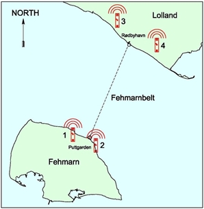
Figure 3. Approximate locations of the four permanent GNSS stations at
Fehmarnbelt. Illustration: Rambøll Danmark.
The foundation of the pillars reaches several meters into the ground
to ensure long term stability of the stations. The monument head is
bevelled at an angle of 30° from vertical in order to minimize signal
multipath effects.
The stations are equipped with individually calibrated GNSS choke
ring antennae mounted on concrete pillars with a height of 3 meters.
The GNSS stations are equipped with GNSS receivers which can process
GPS, GLONASS, and Galileo signals. At the time of writing reception of
Galileo signals has not yet been implemented, however, once a sufficient
number of Galileo satellites are in orbit and operational, Galileo will
also be implemented in the Fehmarnbelt Positioning System.
All the electronic equipment necessary to operate the permanent GNSS
stations are located in cabinets adjacent to the pillars. The cabinets
contain GNSS receivers, access points to power grids, an uninterruptible
power supply (UPS) to bridge power outages, communication equipment, and
a heat exchanger to cool the cabinet.
GNSS data is stored locally in the receivers and is transmitted in
real time to a control center where the data is used for a real time
kinematic (RTK) service. Communication between control center and the
GNSS stations is carried out using the mobile telephone network. RTK
correction data is returned to the GNSS stations and transmitted to RTK
users via a Yagi antenna mounted on radio masts located directly north
of the GNSS antennae. The radio masts are located north of the GNSS
stations to minimize signal blockage since the satellite constellation
at the latitude of Fehmarnbelt, around 54.6 degrees North, provides very
few satellites in this direction.
Establishment of the GNSS stations was carried out after an EU tender
won by the company AXIO-NET GmbH in Germany with Allsat GmbH network and
services as a major subcontractor.
2.2 Geodetic reference system and reference frame
Once the GNSS stations were constructed the next step was to
establish a geodetic reference frame and as a basis for that a geodetic
reference system is needed.
We decided to use the International Terrestrial Reference System
(ITRS) (Tscherning, ed., 1992). This system is used for GNSS and using
it we ensure a tight connection between the Fehmarnbelt geodetic
infrastructure and the global satellite navigation systems. Because the
ITRS is used globally it is also familiar to international contractors.
The reference frame chosen is the ITRF2005 (Altamimi et al., 2007)
which was the newest and most accurate realization of the ITRS at the
time of definition of the reference frame. The four permanent GNSS
stations described in the previous section form the local realization of
the ITRF2005. This was achieved by using seven days of GNSS data from
the four new stations along with data from six surrounding existing
permanent GNSS stations of the network of the International GNSS
Service, the IGS (Dow et al., 2009).
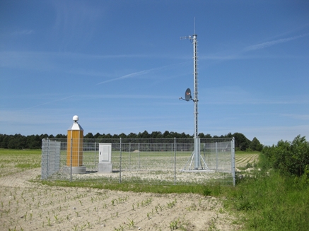
Figure 4. Permanent GNSS station on Lolland, Denmark. Photo: Anna B.O.
Jensen.
Coordinates for the new stations were determined by the Danish
Geodata Agency relative to the IGS stations using the Bernese Software
version 5.0 (Dach et al, 2007) developed at the University of Bern in
Switzerland. Processing was carried out using the standard settings of
the software which includes using the Niell model for estimation of the
tropospheric delay, resolution of ambiguities using the quasi ionosphere
free (QIF) strategy, daily ionosphere models from the Center for Orbit
Determination in Europe (CODE), ocean tide models from Onsala Space
Observatory, and final satellite orbits from the IGS. Hereby, the
ITRF2005 was realised in the Fehmarnbelt area and a reference frame in
three dimensions was established.
To ensure continued stability of the GNSS stations, coordinates have
been verified by re-processing at regular intervals. For each
re-processing a new data set consisting of seven days of data is used.
The data is processed in the current reference frame used for the IGS
satellite orbits and transformed back to the original epoch of the
ITRF2005 using a 7 parameter Helmert transformation. This has been
carried out using a selection of permanent GNSS stations which have been
included in both the original processing and the current re-processing.
So far reprocessing of the station coordinates has not revealed any
significant station movements since the stations were erected in 2010.
2.3 Height system and geoid model
The height difference between Germany and Denmark across Fehmarnbelt
is known from a hydrostatic levelling between Puttgarden and Rødbyhavn
carried out in 1987 (Andersen, 1992).
For the Fehmarnbelt Fixed Link, precise levelling was carried out
between the connecting points of the hydrostatic levelling and stable
points further inland. Levelling points with large displacements since
1987 were eliminated. The hydrostatic levelling was then used for
transfer of the height difference between Germany and Denmark.
The next step was determination of present mean sea level in the
Fehmarnbelt and establishment of a project specific height system with
the zero-level of the height system as close as possible to the actual
mean sea level of Fehmarnbelt.
Water level data from Puttgarden in Germany and Rødbyhavn in Denmark
was analyzed in cooperation with the Danish Geodata Agency and the
Danish National Space Institute at the Technical University of Denmark
(DTU-Space). Analyses of the last 20 years of water level data show an
increase in the water level of approximately 2 mm per year at Rødbyhavn.
The water level data was used for estimation of the present day mean
sea level in Fehmarnbelt, and the zero level for the vertical reference
system for the Fehmarnbelt Fixed Link was hereby set to coincide with
mean sea level at Rødbyhavn in 2010. The zero level thus deviates from
both the German and the Danish height systems with a few centimetres.
After establishing the zero level, precise levelling was carried out
by the Danish Geodata Agency to determine heights in the new vertical
reference system for the four new permanent GNSS stations as well as for
a number of existing control points in Germany and Denmark.
In order to determine heights relative to mean sea level with GNSS it
is necessary to utilize a geoid model. The Danish National Space
Institute (DTU-Space) performed a few new gravity readings to supplement
the existing gravity database. All existing gravity data from the area
collected by German and Danish authorities was then used together with
the new observations to develop a local geoid model for the Fehmarnbelt.
The geoid model was computed by the GRAVSOFT system, a set of Fortran
routines developed by DTU-Space and the Niels Bohr Institute, University
of Copenhagen (Forsberg and Tscherning, 2008). The geoid model is fitted
to the height system and to the ITRF2005 by the four new permanent GNSS
stations, and the model is used for conversion between mean sea level
heights and ellipsoidal heights within the area.
2.4 Map projection
For maps, charts, and drawings a map projection must be defined for
the project. A Transverse Mercator projection (like ITM, UTM or
Gauss-Krüger) was chosen. For a description of map projections see
Bugayewskiy and Snyder (1995). The projection is fitted to the area in
order to obtain a scale factor as small as possible within the
construction area. Also a false Easting value was chosen to provide
Easting values within the construction area which are different from
Easting values of the ITM, UTM and Gauss-Krüger projections being used
in Germany and Denmark. Hereby we hope to reduce the risk of
accidentally using coordinates from a wrong map projection or reference
frame.
2.5 Coordinate transformations
Finally, as the last part of the geodetic infrastructure, coordinate
transformation parameters between the geodetic reference frame used for
the Fehmarnbelt Fixed Link (ITRF2005) and the National reference frames
used in Germany and Denmark (realisations of the ETRS89) were derived.
There is a difference between the realisations of ETRS89 in Germany and
Denmark, and even though this difference is only a few cm it is larger
than the positional accuracy which can be obtained using the RTK service
as described in the next section. It is therefore necessary with two
sets of transformation parameters; one for the German and one for Danish
implementation of the ETRS89. For each set, the variables for a seven
parameter affine transformation were derived specifically for the
relatively small construction area to achieve high accuracy. The
transformation parameters were derived using coordinates of permanent
GNSS stations and a number of 3D control points for which coordinates
were available in the systems involved in the transformation.
Transformation parameters along with map projection, reference system
and geoid model were subsequently built into a transformation software
developed by the Danish Geodata Agency. The software makes it possible
to convert coordinates between the geodetic basis for the Fehmarnbelt
and the national geodetic reference frames, map projections, and height
systems used in Germany and Denmark. This software is also considered
part of the geodetic infrastructure.
3. GNSS RTK service
To ensure accurate GNSS positioning a real time kinematic (RTK) GNSS
service has been established. Establishment, operation and maintenance
was awarded to AXIO-NET GmbH in Germany after an EU tender.
The RTK service is based on the four permanent GNSS stations
described above. Also, data from four secondary GNSS stations located
further away from the construction area are included for better
estimation of for instance atmospheric effects on the GNSS signals. A
total of eight GNSS stations hereby form the basis for the RTK service
In Figure 1, station locations are marked with green circles. FEH1 to
FEH4 are the primary permanent GNSS stations established by Femern A/S.
Secondary permanent GNSS stations are located in Nakskov (NAK1) and
Gedser (GESR) in Denmark, and Kiel Holtenau (HOL2) and Rostock
Warnemünde (WARN) in Germany.
The RTK service is based on a network RTK approach using the GNSMART
software (GEO++ GmbH, 2010). GNSS raw data is sent in real time from the
GNSS stations to the control centre where processing of RTK correction
data is carried out. RTK corrections are then sent back to the four
primary GNSS stations and are transmitted to users in the construction
area via UHF radio and via mobile network.
With the use of a network approach, the RTK service is not affected
if one of the GNSS stations breaks down because RTK correction data can
be generated with a sufficient quality based on data from the seven
remaining stations.
In designing the system, a high level of redundancy has been
achieved. There are for instance two different control centre's
operating at two different addresses in Germany. Also the RTK service
has been designed with a single station RTK backup solution. This means
that if the connection between a GNSS station and the control centre is
interrupted, then the GNSS station switches automatically to a single
station approach. In such situation the GNSS station calculates its own
RTK corrections and transmits these to the users.
The data format used for transmission of RTK corrections is the RTCM
version 3.1. This is used for RTK corrections generated both from the
network approach and the backup single station approach.
The RTK correction data is transmitted to users by UHF radio links on
four different frequencies from the radio masts established at the new
GNSS stations. But RTK corrections are also distributed via the internet
using the NTRIP protocol. The radio link is used as the primary data
link because the data communication is free and because a sufficient
line of sight is available across the Fehmarnbelt. Mobile internet and
NTRIP protocol is mainly used when working further inland where the
topography may limit transmission of the radio signals. It is also used
offshore by contractors who are more familiar with using the NTRIP
protocol from other construction projects.
3.1 Test of rovers with the RTK service
One of the requirements for the RTK service is that the service
should be available for, and useable by, contractors with different
brands of GNSS RTK rover equipment. To verify that this was indeed
possible, a test of different rovers was carried out in June 2014. We
tested RTK rovers from Trimble, Leica, Topcon, and Javad considering
that these brands will most commonly be encountered on the construction
site. Only new equipment was used for the test and the equipment was
rented from the various dealers in Denmark.
For reception of UHF radio signals a SATEL radio modem was connected
via cable to those receivers which did not have built in radio modems.
The test showed that the RTK service could indeed be used with all four
brand names of receivers and fixed positions were obtained using both
radio and mobile internet (NTRIP). Time to fix ambiguities was
comparable between units and acceptable accuracy was obtained when the
equipment was tested at a few control points. Further, some changes to
the transmitted RTCM data of the positioning system were tested such as
switching GLONASS and/or MAC correction data off and on.
3.2 Operational status and maintenance
Continuous maintenance is carried out to make sure the positioning
system consistently meets the requirements set by Femern A/S.
Maintenance includes re-processing of coordinates for the GNSS
stations to verify station stability. Monthly inspections of the GNSS
stations are carried out to make sure the stations, including hardware
and communication lines, are continuously operating at their best.
Considering the long term operation of the system, monitoring, and
potential replacement of electrical parts is also carried out.
Verification and control of the performance of the RTK service is also
carried out at regular intervals by AXIO-NET GmbH who operates the
system.
During establishment and operation of the system, coordination,
quality control and supervision is carried out by Rambøll-Arup-TEC JV
and AJ Geomatics, authors of this paper, for Femern A/S.
4. CONCLUDING REMARKS
The paper has described the tasks and the sequence of steps carried
out in establishment of a
geodetic infrastructure and positioning system for the
pre-investigations and construction work of the Fehmarnbelt Fixed Link.
The geodetic infrastructure consists of a geodetic reference frame,
map projection, height system, geoid model and coordinate
transformations all defined and realised especially for the large
construction project. A transformation software has been developed
specifically for the project for easier use.
Four permanent GNSS stations form the basis for the geodetic
reference frame and are also used as the basis for an RTK service
providing GNSS RTK correction data for precise positioning and
navigation in the area.
Several tests have been carried out during the establishment, and
continuous surveillance and maintenance is carried out to make sure the
system meets the requirements of the construction project.
The approach described in this paper suggests the work process for
establishment of a geodetic infrastructure for a large construction
project. Other approaches could have been followed, but for this project
the described procedure so far has worked out well. It has been
advantageous for the establishment and testing of the geodetic
infrastructure and positioning system, that work on this was initiated
as one of the first tasks in the preparatory work for the Fehmarnbelt
Fixed Link.
ACKNOWLEDGMENTS
All of the work described in this article is funded by Femern A/S,
and many public and private organisations in Germany and Denmark have
been involved in the work.
AXIO-NET GmbH is the lead contractor responsible for establishment
and operation of the permanent GNSS stations and operation and
maintenance of the RTK service.
Allsat GmbH network and services managed establishment of the
permanent GNSS stations and provided GNSS hardware. Richter
Deformationsmesstechnik GmbH established the GNSS pillars, radio masts,
cabinets etc. of the permanent GNSS stations, and Ohms Nachtigall
engineering GbR performed geo-technical investigations at the sites of
the GNSS stations prior to establishment.
The Danish Geodata Agency has been involved in most parts of geodetic
work and has performed much of the geodetic survey activities and much
of the data processing and analyses. The Danish National Space Institute
(DTU-Space) developed the geoid model and contributed to definition of
mean sea level. The Federal Agency for Cartography and Geodesy in
Germany (BKG) and the Land Survey Office of the State of
Schleswig-Holstein in Germany has supported much of the work on the
geodetic infrastructure.
Disclaimer: The opinions and conclusions presented in this paper do
not necessarily cover the opinions and conclusions of Femern A/S.
REFERENCES
Altamimi, Z., X. Collilieux, J. Legrand, B. Garayt and C. Boucher,
2007. ITRF2005: A new release of the International Terrestrial Reference
Frame based on time series of station positions and Earth Orientation
Parameters. Journal of Geophysical Research, Vol. 112, B09401, 19 pp.
Andersen, N., 1992. The Hydrostatic Levelling Across Fehmarn Belt in
1987. Publications 4th Series, National Survey and Cadastre – Denmark.
Bugayewskiy, L. M., and J. P. Snyder, 1995. Map Projections, a
Reference Manual. CRC Press.
Dach, R., U. Hugentobler, P. Fridez and M. Meindl (eds.), 2007.
Bernese GPS Software Version 5.0. User manual of Bernese GPS Software
Version 5.0. Astronomical Institute, Univ. of Bern. Available for
download at www.bernese.unibe.ch/docs/DOCU50.pdf.
Dow, J.M., R.E. Neilan, and C. Rizos, 2009. The International GNSS
Service in a changing landscape of Global Navigation Satellite Systems,
Journal of Geodesy 83:191–198, DOI: 10.1007/s00190-008-0300-3
Forsberg, R and C C Tscherning, 2008.Overview manual for the GRAVSOFT
Geodetic Gravity Field Modelling Programs, 2nd Ed. Technical report,
DTU-Space, Technical University of Denmark.
Geo++ GmbH, 2010. GNSMART General Online Help. GNSMART Documentation
1.4.0.9, 08 June 2010. Available for download at
www.anton.geopp.de/realtime/
Tscherning, C.C. (ed.), 1992. The Geodesist's Handbook 1992. Bulletin
Geodesique, Vol. 66, no. 2.
BIOGRAPHICAL NOTES
Anna B. O. Jensen is professor in geodesy at KTH - Royal
Institute of Technology in Sweden, and owner of AJ Geomatics in Denmark.
She holds a Ph.D. in geodesy from the University of Copenhagen and has
worked with research and development in geodesy and GNSS for more than
20 years.
Anders Almholt is a senior analyst at Rambøll Danmark. He
holds a M.Sc. degree in geophysics from the University of Copenhagen and
has worked with ground engineering for more than five years.
CONTACTS
Professor Anna B.O. Jensen
KTH - Royal Institute of Technology
Division of Geodesy and Satellite Positioning
Drottning Kristinas Väg 30
100 44 Stockholm
SWEDEN
Tel. + 46 8 790-7353
Email: abjensen@kth.se
Web site:
www.kth.se/profile/abjensen/
|