Post Disaster Consolidation of Land, Memory and
Identity
Walter Timo DE VRIES, GERMANY
1)
This peer reviewed paper was presented at the FIG Working Week in
Christchurch, New Zealand, 2-6 May 2016. This paper takes a closer look
at the post-disaster re-development plan for urban areas, with a
particular focus on reconsolidating historical social memory and
preservation of identity. This is done using two well-documented cases
of urban disasters: the firework disaster in Enschede/Netherlands in
2000 and the Merapi disaster in Yogyakarta / Indonesia 2010
SUMMARY
Disasters in cities contain severe destruction of buildings and loss
of access to land. Consequently, a post-disaster re-development plan may
need to rely on different land consolidation approaches. An associated
dilemma is to re-establish the built-up area in its original formal
shape, or to innovate the urban design partially or completely. An
important consideration in the allocation of new land and building
rights is whether to restitute former rights or allocate new rights.
Participation of former residents and firm owners alongside overcoming
the immense social trauma are crucial elements of this process.
The aim is to derive new land consolidation optimization criteria
which could support urban post disaster land consolidation. The guiding
hypothesis hereby is that consolidation of memory and identity are two
important aspects which need to be incorporated in land consolidation
design and implementation procedures in order to ensure ownership of the
consolidation result and to help overcoming the social trauma.
Land consolidation theory has primarily been rooted in agricultural
economics and land management. The concept of optimization during the
consolidation processes can however be critically questioned from the
perspective of social disaster mitigation experiences. In this body of
literature it is argued that the return to daily life after a disaster
requires both a sufficient acknowledgement that humans tend to want to
re-install historically known artefacts in order to be able to
reintegrate into regular new social routines. This is summarized by the
concepts of memory consolidation and preservation of identity. These
concepts provide an analytical way to question contemporary urban land
consolidation approaches.
Two relatively recent specific cases were used to assess the degree
to which elements of memory consolidation and identity preservation are
incorporated in post disaster land consolidation: the firework disaster
in Enschede, Netherlands in 2000, and the Merapi disaster in Yogjakarta,
Indonesia in 2010. These cases were chosen because sufficient
documentation has been collected, and it was still possible to acquire
additional data from people who had experienced both the previous and
post disaster situation.
Both cases exhibited considerable attention for the simultaneous
processes of reconstruction and participation in the land consolidation
processes. Participation is often framed as a process which has to be
stimulated during a technical land consolidation and reconstruction
process. In some instances it is however an endogenous social process
whereby citizens claim ownership of the process prior to the technical
reconstruction. Especially in the resurrection of historical monuments
and/-or in the delineation of areas with spatial significance in
relation to the disasters.
Where conventional consolidation approaches in rural areas tend to
emphasize the need to optimize agricultural production or environmental
protection, optimization indicators in post disaster consolidation need
to be adapted. Especially procedures and tools to incorporate memory
consolidation and identity preservation need to be incorporated. This
can be done theoretically, but still requires further research and
actual implementation experiences into how to consolidate that into
current institutional procedures and operational software packages.
1. INTRODUCTION
In the past 15 years there have been an increasing number of urban
disasters, the most prominent ones being the 2011 earthquake in
Christchurch / New Zealand, 2011 earthquake and Tsunami affecting
various urban centres in Japan, the 2010 earthquake affecting
Port-au-Prince in Haiti and the 2004 south East Asian Tsunami affecting
Banda Aceh amongst others. A disaster is ‘a sudden, calamitous event
that seriously disrupts the functioning of a community or society and
causes human, material, and economic or environmental losses’ (IFRC) .
Besides the natural disasters there is also an increase in mand-made
disasters, usually due to an increase in traditional hazards such as
fires and explosions, or due to human conflicts, terrorism, war, human
errors, irresponsible settlement or mismanagement in planning. Both
natural and man-made disasters manifest themselves with loss of lives
and usually severe loss of buildings. Sustainable reconstruction after
disasters takes place when the immediate threat of the disaster event
has disappeared. In this phase there is an urgent need to rehabilitate
livelihoods, reconstruct buildings and infrastructure and (re-) allocate
land and building rights. Here, spatial planners, land managers,
architects and civil engineers play a crucial role.
For both types of disaster a key characteristic of urban disasters is
that they - besides the loss of lives and severe destruction of
buildings - are accompanied a loss of access to land and real estate
property. In the process of reconstruction, a post-disaster
re-development plan may needs to rely on different land consolidation
approaches. Not only may previous owners and occupants of land and
buildings have died as a result of the disaster or do the buildings no
longer exist (as a result of which reallocation of ownership may be
necessary), also the entire infrastructure may prevent the immediate
reconstruction of the area in exactly the same shape. A reconstruction
dilemma is therefore to re-establish the built-up area in its original
formal shape, or to innovate the urban design partially or completely.
An important consideration in the allocation of new land and building
rights is whether to restitute former rights or allocate new rights.
Participation of former residents and firm owners alongside overcoming
the immense social trauma are crucial elements of this process. In other
words, land consolidation and reconstructing property should not only
cater for the administrative process, but also take the social
reconsolidation into account. This article takes a closer look at what
this consist of, with a particular focus on reconsolidating historical
social memory and preservation of identity. This is done using two
well-documented cases of urban disasters: the firework disaster in
Enschede/Netherlands in 2000 and the Merapi disaster in Yogyakarta /
Indonesia 2010. In these cases the degree to which elements of memory
consolidation and identity preservation are incorporated in post
disaster land consolidation are assessed.
2. URBAN LAND CONSOLIDATION
The conventional association of the scope and utilization of land
consolidation is with agricultural economics and rural development. FAO
(2003) refer to land consolidation as Land consolidation can assist
farmers to amalgamate their fragmented parcels. For example, a farmer
who owns one hectare divided into five parcels may benefit from a
consolidation scheme which results in a single parcel. In many eastern
European (FAO, 2004) and African land consolidation programs tend to
have primarily such an economic production (Musahara, Nyamulinda,
Bizimana, & Niyonzima, 2014) and/or and rural development focus
(Bullard, 2007). Musahara et al. (2014) describes this micro-economic
agrcultural benefit in the cases of Rwanda, where the Land Use
Consolidation (LUC) programme was initiated in 2008 as part of a broader
Crop Intensification Programme in Rwanda launched earlier in 2007.
More recently land consolidation is associated specifically to a
societal benefit or public value, such as food security (Bennett, Yimer,
& Lemmen, 2015) or environmental protection (Louwsma et al., 2014). Not
the micro-economic agricultural production values count in these cases,
but the public values at a larger – often national or regional - scale.
The optimal output of a land consolidation process then needs to be
evaluated in terms of this societal benefit, rather than a pure economic
benefit.
Method-wise, Louwsma and Lemmen (2015) introduce land consolidation
as an instrument to counteract land fragmentation and the associated
negative impact on the productivity and costs of farming. The most
common interpretation of land fragmentation relates to physical aspects
of fragmentation, i.e. holdings with a large number of small parcels
scattered over a considerable area. (Savoiu, Lemmen, & Savoiu, 2015)
indicate that different types of land consolidation exist which each
require different methodologies of implementation and different
indicators of optimization. Vitikainen (2004) specifies such indicators
of land consolidation are (Vitikainen, 2004): defragmentation of parcel
size and location (improvement of agricultural and/or forest land
division, re-allotment of leasehold areas, enlargement of farm size),
reconstruction of urban areas (land use planning in village areas,
readjustment of building land), creation of accessibility to roads and
utilities (improvement of road network, drainage network), environmental
protection and planning (implementation of environment and nature
conservation areas), spatial and regional development (promotion of
regional development). Demetriou, See, and Stillwell (2013) further
specify procedures and decision support systems to quantify the
resultant optimization parcel sizes.
Louwsma and Lemmen (2015) acknowledge that there are multiple
socio-economic dimensions of fragmentation. Participation and embedding
of economic, technical informational and infrastructural solutions in a
societal context is considered of crucial importance (Louwsma, Van Beek,
& Hoeve, 2014). Especially in urban disasters parcel fragmentation is
however not the key problem when reconstructing and returning to daily
life. Moreover, also the methods, processes and key indicators used on
rural land consolidation do not seem to fit the objectives of urban land
consolidation. Plot size, land value are not the primary elements, but
rather public value, participation, resilience and public acceptance.
Furthermore, in urban areas there is a different sense of neighborhood
and spatial identity.
Based on the above considerations, Figure 1 summarizes the land
consolidation approaches and its optimization criteria relevant for the
consolidation tools and instruments. The traditional land consolidation
optimizes on economic productivity or collective micro-economic benefit.
When emphasizing socio-cultural embedding, optimizing public values
become more important. Real participation in all steps of a land
consolidation process, including participating on which values are
crucial for the stakeholders, optimize on criteria which are
recognizable and identifiable by stakeholders.
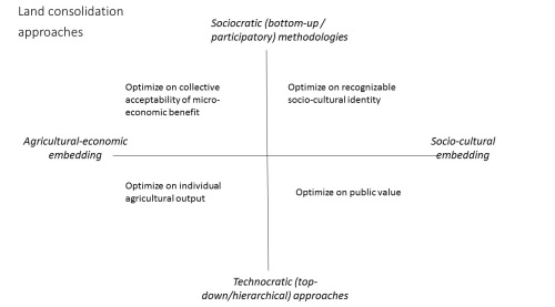
Figure 1. Summary of land consolidation
approaches and optimization criteria
3. MEMORY AND IDENTITY
The analytical framework to evaluate this documentation relied on the
conceptualization of post-disaster ’memory’ by Bevan (2006) and urban
cultural identity by (Boom, 2009). Although Bevan (2006) primarily
focuses on the deliberate (instead of accidental) destruction of
cultural heritage during man-made disasters, such as war times and
terrorists attack, implicitly he conceptualizes cultural memory from an
extensive description of symbolic meanings which are manifested in
specific buildings, locations and infrastructure. The Twin Towers attack
on 11 September 2011 indeed destroyed 110 floors of two prominent
buildings, but essentially the symbolic value of that physical
destruction was related to a difference in historically grown and
accepted cultural and societal values. Similarly, the 1993 destruction
of Stari Most bridge in Mostar, Bosnia-Herzegovina during the Balkan war
and the more recent destruction of world heritage site Hatra in Mosul,
Iraq, in the contemporary war of Islamic State is primarily meant to
destroy collective memory and spatial-physical anchor points of societal
fabric. Both were symbols and meeting point of a multicultural and
cosmopolitan society, with ethnically mixed marriages and religious
diversity. The destruction of the physical artefacts was an immediate
statement against such cultural values and identities.
As cultural identity and collective memory depend on imitating and
prolonging traditions on the one hand and physical recollection of the
past or personal linkages from the present to the past, reconstructing
artefacts with the aim to restore previously existing values needs to
make both a physical and symbolic connection to the past. The simplest
way is imitation of the past. Architectural building imitations rely on
procedures and methods to re-erect the buildings and artefacts in the
exactly the same shape as before. Many cities after the Second World War
were reconstructed in this way. Although this did result in some degree
of cultural memory reconstruction, it became also clear that the
buildings lost value in authenticity, because they were no longer
original and could no longer be identified with the building labour of
the past (Denslagen & Gutschow, 2005).
Instead of exact imitation which is primarily based on the physical
artefacts, it is also possible to rely on the personal memories and
values of the people involved. Monuments, for example, are one way to
prolong the collective memory of people, rather than to bring back the
buildings of the past. In line with this reasoning, land ownership
imitations could be one way to complement the cultural memory
reconstruction. This is where land consolidation touches memory
consolidation. Symbolic land consolidation is then more related to
common land artefacts which have some public significance, such as
historical sites or parcels of land or buildings with significant value
to local communities. Such values can often not be recognized by
physical objects, but only be identified by extensive discussions with
local representatives of both the past and the future.
4. URBAN DISASTER CASES
Two urban disaster cases were identified for this research, which
were different in location, size, impact and origin of disaster. Similar
was however that land consolidation took place, and that this process
was relatively well documented. The 2000 firework disaster in a
residential area, Roombeek in Enschede, in the east of the Netherlands
near the German border on 13 May 2000. The blast had destroyed 400 homes
and damaged 1500 buildings of the residential area. The documentation of
this case is largely based on the documentation aggregated by the
dedicated websites http://www.roombeek.nl,
http://www.enschede-stad.nl/projecten.php?project=Roombeek , and the
theses of de Groot (2005), Langereis (2014). The second case concerns
the Merapi volcanic disaster in Yogyakarta / Indonesia which took place
in October-November 2010. Over 350,000 people were evacuated from the
affected area. The volcanic material from the eruption overflowed the
river running through the province of Yogyakarta, inundating hundreds of
houses along the riverbank. After the mudflow subsided, people returned
to their homes, and reconstruction started, yet the area remains prone
to the next disaster if not accompanied by proper planning and land
management. Land consolidaiton is an important part of this. The data of
this case are largely based on the documentation and reports of the
provincial office of Yogyakarta of the Indonesian land agency BPN (BPN
Provinsi Daerah Istimewa Yogyakarta, 2014).
4.1 Land consolidation after Firework disaster Enschede,
Netherlands, 2000
The reconstruction and consolidation of the Roombeek area employed
new methods of spatial planning and management, allowed many architects
to design individual houses and relied on new urban consolidation
methods. In other words, the disaster also opened up new ways of
reconstruction and reconsolidation. The boundary of area Roombeek in
Enschede is closely related to recent history. Being originally an area
of textile factories, the area consisted of a mix of working class
houses, factory areas, small parks, middle class residential areas and
estates of textile factory owners. This mix of land use and economic
activity explains why it was possible that a firework storage resided in
the area. However on the fatal day of the disaster 177 ton of firework
exploded after a chain reaction of smaller explosions. It wiped out an
area of 42,5 hectare (the approximate size of the Vatican city),
affected 650 houses, 500 small sized enterprise buildings and 8
associations residing in buildings. A total of 23 people were killed,
whilst approximately 950 people got injured.
The reconstruction of the area was subcontracted to a specific
project bureau ‘Projectbureau Wederopbouw Roombeek’ (PWR) under the
supervision of the urban designer Pi de Bruijn. In addition to the new
urban design, and information and advisory centre (IAC) was established
with the aim to help victims cope with the traumatic experiences and
support them with information needs and psychological help.
Furthermore, a foundation city recuperation (SSE) was established to
make an inventory of the damage to houses and property. Both IAC and
SSE currently no longer exist, but they played a pivotal role in the
reconstruction alongside the PWR.
The process of reconstruction had one central objective:
participation. Members of the PWR visited victims and discussed requests
and needs during and after reconstruction. This resulted in a collation
of 3000 opinions and ideas to reconstruct the new area Roombeek. The
objectives included:
-
Maintain the area as a specific quarter with its own
characteristics, especially the mixed types of social and economic
activity and socio-economic backgrounds
-
Ensure the possibility for all previous residents and small
enterprises to return to the area
-
Maintain part of the original layout of the area
-
Maintain or reconstruct old industrial buildings and restore the
industrial heritage
-
Ensure that the area has an economic future
-
Interconnect the area as closely as possible with surrounding areas
/ quarters
-
Support autonomy of the area in terms of development and economic
activity
These objectives led to a reconstruction and consolidation plan in
which diversity and multi-functionality were key and preservation of
both cultural and economic identity was important. The reconstruction
plan included:
- 1500 houses of which 150 were renovated
- An area for 4000 residents
- 400 private companies – small-sized businesses
- 1200 commercial work places – working from home – were
established
- 4500-8000 m2 of retail
- Studio spaces and room for culture
- Maintenance of industrial heritage (through reconstructing older
factories)
- Close accessibility to neighboring areas through access
corridors
The reconstruction of houses and buildings formed a trend break in
Dutch urban planning practices. Instead of subcontracting all housing to
large real estate developers (thereby ignoring all possibilities of
public participation), the project bureau deliberately opted for
allowing private housing projects (in addition to the social housing).
This allowed people to influence their own working and living
environment with the support and supervision of professional experts.
Parcels were individually re-allocated with a limited number of
conditions. A total of 400 people opted for this possibility and each
created their own style house, which promoted the variety.
The industrial factory remnants were reconstructed into museums, art
schools, studio spaces, small apartments and small office spaces. It
maintained the look and feel of factories, be it that the usage has
changed. This also implied a change of land and building ownership and
use as compared to the previous status.
4.2 Land consolidation after Merapi eruption and subsequent flooding
in Yogyakarta province, Indonesia
The Merapi eruption especially affected areas close to the crater.
Material bursts of Mount Merapi damaged several villages in the region
of Sleman, destroying thousands of homes and affecting ownership of
local residents. To avoid the potential of land conflict the provincial
land agency decided to execute a land consolidation process,
specifically in the local villages surrounding the area of village of
Cangkringan. This process is well-documented in the BPN reports, the
final report being ADDIN EN.CITE BPN Provinsi
Daerah Istimewa Yogyakarta20142591(BPN
Provinsi Daerah Istimewa Yogyakarta, 2014)2591259127BPN
Provinsi Daerah Istimewa Yogyakarta,
Laporan hasil akhir konsolidasi tanah tahun 2014.3962014Badan
Pertanahan Nasional Republik Indonesia(BPN
Provinsi Daerah Istimewa Yogyakarta, 2014). The land consolidation plan
was based on 4 pillars:
- the regional spatial plan, primarily targeting re-establishing
and reconstructing economic activity such as agriculture;
- infrastructure development associated with the handling and
control of disasters;
- local topographical conditions,
- community participation.
After 4 years the reported results included:
- The availability of public facilities and social amenities
without moving the landowner;
- A financing model whereby the land owners profited from land
development;
- Optimization of road and parcel infrastructure;
- Allocation and control of land ownership rights by title
certification.
The spatial plan for the next 20 years also included that it would
not be allowed to live in a residential development area directly
affected eruption Merapi 2010; that it would not be allowed to add new
facilities and infrastructure in the affected areas Direct eruption
2010; and, that land utilization would only be allowed for special
interest tourism, agriculture, plantation and reforestation in areas
directly affected the eruption in 2010.
One of the main reasons why it was possible to find support for these
plans and execute the land consolidation without any major resistance
was the presence of ‘gotong royong’ (mutual aid) among people in a
certain community, which is an Indonesian tradition, rooted in Javanese
culture, to support among others the reconstruction of each other’s
houses.
4.3 Comparative summary of results
Table 1 summarizes and compares the results with regard to different
aspects of the reconstruction:
| Aspects of
reconstruction |
Firework disaster in Enschede
|
Merapi disaster in Yogjakarta
|
| Objectives of
reconstruction |
Preservation of area characteristics,
and support autonomous development |
Land consolidation to avoid potential
for land conflicts |
| Objectives of
reconstruction |
Preservation of area characteristics,
and support autonomous development |
Land consolidation to avoid potential
for land conflicts |
| Key claims of
success and results of reconstruction |
Support autonomy of
the local community in the area of development |
Gotong royong, a Javanese tradition, to
support each other within the community |
| Key claims of
success and results of reconstruction |
Support autonomy of the local community
in the area of development |
Optimization of land management and land
rights distribution alongside sustainable financing model |
Figure 1. Summary of land consolidation
approaches and optimization criteria
Table1. Summary and comparison of results
5. DISCUSSION
Both cases exhibited considerable attention for the simultaneous
processes of reconstruction and participation in the land consolidation
processes. Although participation is a word that is frequented mentioned
in the documentation and success factors in both cases, it is often
framed as a process which has to be stimulated during a technical land
consolidation and reconstruction process. It is a passive participation,
whereby – perhaps formulated a bit black and white, but to make the
point clear - stakeholders either need to be convinced of their possible
benefits of the land consolidation, or stakeholders become gradually
informed of their benefits and rights. The economic perspective of land
consolidation tends to be on the forefront, either in the form of
agricultural productivity or in the form of economic potential of small
businesses. The participation is than considered a dependent factor of
economic optimization rather than the opposite.
At the same time there is however also evidence that the
participation is an endogenous social process whereby citizens claim
ownership of the process prior to the technical reconstruction.
Especially in the resurrection of historical monuments and/-or in the
delineation of areas with spatial significance in relation to the
disasters. This refers to the symbolic consolidation alongside the
physical consolidation. In fact, memory is preserved and optimized
rather than economic value.
A second issue which comes back in both cases is the explicitly
defined objectives to seek long-term security. This security is however
mainly formulated as a perception of security. Feeling comfortable and
feeling security are passive characteristics of such a perception. After
reconstruction these perceptions should be fostered and optimized. More
actively, reconstruction and land consolidation focuses on building
attractiveness. This may seem a vague concept, but it is literally
formulated in both cases as a planning principle. Apparently,
attractiveness is a societal value which can be used as a concept to
bridge shared perceptions to hard planning aims. This type of
optimization indicator is one that often does not appear in most land
consolidation reports or essays.
Finally, for the specific urban context of the Roombeek cultural
historical, architectural and urban design value (in addition to
economic value) is considered important. This requires an insight into
the industrial and constructive elements of buildings, knowledge and
experience with light, usage of visual elements, spatial perception,
functionality of buildings and public spatial element, and the
psychology of the environment. This finding relates both to a cultural
value and a professional value. Such values may not be very explicit,
yet they are recognizable in so-called epistemic communities, i.e.
communities who shared among each other similar values, rules and
traditions. Consolidating epistemic values often does not occur by hard
rules, rather by soft rules or isomorphic behavior. Yet, adhering to
such values and acknowledging such values is crucial for the acceptance
of the technical land consolidation solution.
6. CONCLUSION AND RECOMMENDATIONS FOR FURTHER RESEARCH
Where conventional consolidation approaches in rural areas tend to
emphasize the need to optimize agricultural production or environmental
protection, optimization indicators in post disaster consolidation need
to be adapted. The main reason is that post-disaster consolidation also
needs to take into account how to cope with the social trauma. The
societal context and the social values existing prior and after the
disaster are thereby critical. Socio-cultural embedding, optimizing
public values as well as active participation in all steps of a land
consolidation process, prior, during and after the land consolidation
process are decisive. Consolidation of memory and identity needs to be
enacted alongside realizing the micro economic benefits (of either
agriculture, small-medium businesses or real estate). This requires that
procedures and tools to incorporate memory consolidation and identity
preservation need to be incorporated in both hard legal and technical
instruments and soft methods and tools. This can be done theoretically,
but still requires further research and actual implementation
experiences into how to consolidate that into current institutional
procedures and operational software packages.
REFERENCES
Bennett, R. M., Yimer, F. A., & Lemmen, C. 2015. Toward
Fit-for-Purpose Land Consolidation, Advances in Responsible Land
Administration: 163-182: CRC Press.
Bevan, R. 2006. The destruction of memory: Architecture at war:
Reaktion books.
Boom, S. J. 2009. Roombeek. De vernietiging van cultureel
geheugen en de wederopbouw van culturele identiteit (In English: The
destruction of cultural memory and reconstruction of cultural identity).
Universiteit Utrecht.
BPN Provinsi Daerah Istimewa Yogyakarta. 2014. Laporan hasil akhir
konsolidasi tanah tahun 2014. : 396: Badan Pertanahan Nasional Republik
Indonesia.
Bullard, R. 2007. Land Consolidation and Rural Development.
Papers in Land Management. No. 10: 149.
de Groot, F. 2005. Integrale aanpak-Wederopbouw Roombeek: Erasmus
University.
Demetriou, D., See, L., & Stillwell, J. 2013. A parcel shape
index for use in land consolidation planning. Transactions in GIS,
17(6): 861-882.
Denslagen, W. F., & Gutschow, N. 2005. Architectural imitations:
reproductions and pastiches in East and West: Shaker Publishing.
FAO. 2003. The design of land consolidation pilot projects in
Central and Eastern Europe. In FAO (Ed.): 55.
FAO. 2004. Operations manual for land consolidation pilot projects in
Central and Eastern Europe: 69. Rome: Food and agiculture organization
of the United Nations (FAO).
Langereis, M. 2014. Herontwikkeling van industrieel erfgoed:
vervallen monumenten als aanjager voor vernieuwing. Onderzoek naar
bestuursstijlen van de gemeenten Enschede en Deventer.
Louwsma, M., & Lemmen, C. 2015. Relevance of leased land in
land consolidation, FIG Working week - From wisdom of the ages to the
challenges of the modern world: 15. Sofia, Bulgaria.
Louwsma, M., Van Beek, M., & Hoeve, B. 2014. A new approach:
Participatory Land Consolidation 10. XXV FIG Congress, 16-21 June 2014,
Kuala Lumpur, Malaysia. FIG, 2014. .
Musahara, H., Nyamulinda, B., Bizimana, C., & Niyonzima, T.
2014. Land use consolidation and poverty reduction in Rwanda, 2014 World
Bank Conference on Land and poverty: 28. Washington DC.
Savoiu, C., Lemmen, C., & Savoiu, I. 2015. Systematic Registration in
Romania a New Opportunity for Land Consolidation, FIG Working Week -
From the wisdom of the ages to the challenges of the modern world: 29.
Sofia, Bulgaria. Vitikainen, A. 2004. An overview of land consolidation
in Europe. Nordic jounral of surveying and real estate res
BIBLIOGRAPHICAL NOTES
Prof. dr. ir Walter Timo de Vries,
wt.de-vries@tum.de, is chair
land management at the faculty of civil, geo and environmental
engineering at the Technical University Munich. His research interests
include smart and responsible land management, public sector cooperation
with geoICT and capacity development for land policy. Key themes in his
most recent publications advances in responsible land administration,
mergers of cadastres and land registers, capacity assessment
methodologies for land policy and neocadastres.
CONTACTS
Walter Timo de Vries
Technical University of Munich
Lehrstuhl für Bodenordnung und Landentwicklung / Chair of Land
Management
Department of Civil Geo and Environmental Engineering
Arcisstraße 21, 80333 München GERMANY
Tel. +49 89 289 25799 : mobile : +49 (0) 174 204 1171
wt.de-vries@tum.de
Website: http://www.bole.bgu.tum.de
|


