Article of the Month -
January 2006
|
Cadastral Reconstruction in Aceh: A Newborn Concept of
Adjudication
Tony S. HAROEN, Chairul B. ACHMAD and Wenny RUSMAWAR, National Land
Agency / Badan Pertanahan Nasional, Indonesia
 This article in .pdf-format
1)
This article has been presented for the first time at the South East Survey
Congress in Bandar Seri Begawan, Brunei Darussalam, 21-25 November 2005. It
is published as the Article of the Month to show respect to the memory of
the victims of the Tsunami disaster in December 2005.
SUMMARY
Tsunami and earthquake in 26th December 2004 in Aceh, the northern part
of Sumatra Island, have significantly given valuable lessons for all kind of
human living; include the relationship between land and people, which is the
domain of cadastral services. One of the precious lessons is that the
cadastral mind-set needs to be reformatted in line with the new movement to
be more focus to the people rather than to the land or to the right attached
on the land. The increased role of people as one of the stakeholders needs
to be restructured since the Community has the power to be the central of
information provider. Cadastral systems always deal with “who own what,
where and area”. The phrase of “own what, where and area” has successfully
been carried out through legal and geomatics components, leaving the phrase
“who” survive.
In general, if the principal of the deep-rooted of cadastral systems
world-wide constantly leaving the power of people remained intact disregard,
than the issues of cadastral problem-solving are vulnerable. Post Disaster
in Aceh reinforces the importance of having integrated awareness from all
stakeholders regarding the challenges and issues involved in exercising
cadastral services. As a result, a newborn concept of a Community-Driven
Adjudication (CDA) is innovated in undertaking cadastral reconstruction. The
objective of this paper is to promote a better understanding of the nature
of a newborn thought of cadastral approach. It is hoped that the paper makes
a worthwhile contribution to the growing world of knowledge and sciences.
Insya ALLAH.
1. COMMUNITY-DRIVEN ADJUDICATION: A NEW APPROACH OF CADASTRAL
RECONSTRUCTION
The 26 December 2004 earthquake and tsunami in Northern Sumatra has had a
damaging impact on the province of Nanggroe Aceh Darussalam (NAD) or Aceh
(see Photo1). The situation was exacerbated by the March 28th 2005
earthquake which had a significant impact on the Nias Island. Much of the
region's coastal infrastructure, housing, and record systems have been lost
including land records, along with more than 130,000 lives. Approximately
300,000 land parcels were entirely affected by the disaster (160,000 urban,
140,000 rural). The physical presence and evidence of ownership for many of
these parcels of land property have totally been lost. About 90,000
certificates of title were damaged by the Tsunami.
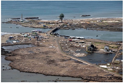
Photo 1. Damaged areas of Aceh
The contribution of cadastral reconstruction to the redevelopment of the
affected areas post disaster is evident at all levels and sectors. However,
exercising the cadastral reconstruction in these areas is far beyond simple
due to the shortage of survived land-owners and of information related to
each land parcel.
The main difficulties of cadastral reconstruction is facing are directly
related to the community need for re-establishing land boundaries, to
accomplish reliability of spatial and juridical data on every damaged land
property.
Theoretically, cadastral reconstruction is relatively straightforward
from the technical viewpoint particularly by utilizing modern technologies.
In spite of this, in overwhelming the complexity situation and condition in
the areas of post disaster is not simply the issue and the exercise of
technology. Cadastral reconstruction deals with the very difficult situation
due to the lack of resources.
The extent of the damage and task facing reconstruction are of a
magnitude unprecedented in recent natural disaster history. Piece of
evidence regarding formal documents on land ownerships are hardly ever and
piece of information becomes critical, due to the total destruction, while
only few land owners have been staying alive. This is an extremely gigantic
challenge for all professions, not only cadastral science. The level of
difficulties in exercising cadastral reconstruction is remarkably superior
that demands an absolutely integrated energy from all stakeholders.
Awareness from all stakeholders of the challenges and issues involved in
exercising cadastral reconstruction has enabled greater preparation prior to
the steps of action being taken. The first step has been to discover the
data availability through various resources, either from the remaining
documents, satellite imageries and information provided by people. This has
been the key driver for the development of cadastral reconstruction and the
focus of development steps forward. The second step has been to identify key
stakeholders involved in the exercise, such as: the survivors, informal
village leaders, non government organizations, and private sector and
government institutions.
The integrated works of all stakeholders has been performed through
local, national and international links to increase sharing and
documentation of experience to facilitate implementation and face the
complexity of decision-support challenges. One of the important consequences
of the second step has therefore been the inclusion of people as the key
stakeholder, alongside technical and institutional elements. In photo 2 the
process of mapping in the village of Kajhu, Aceh Besar has shown the role of
people as the key stakeholder.
Considering the important and dynamic interaction between people and data
required for developing more reliable and effective land records, it is
important to take into account the changing nature of communities and their
needs. In this situation, people recognize that cadastral reconstruction is
all about facilitation and bringing together the reestablishment of
land-people relationships which is fundamental for community needs.
Stakeholders recognize that societal issues are critical factors in
determining the success of cadastral reconstruction.
Therefore, the main important resource is the information flow provided
by people to be integrated into the available data and remaining documents.
The role of information provided by the people becomes the key string in
exercising cadastral reconstruction.
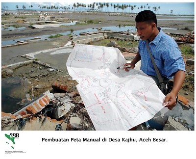
Photo 2. Mapping in the village of Kajhu, Aceh Besar.
It is figured that about 300,000 land parcels have in a straight line
been affected by the disaster, of which only some 60,000 are officially
documented. In the areas, where the devastation was relatively minor, the
reconstructions of border lines amongst properties are to a certain extent
uncomplicated.
There are an adequate amount of survivor members who could give
information of who lived where and owned what. The information compilation
is slightly effortless. Nevertheless, even in this case, disputes may arise,
caused by opportunistic land grabbers or due to uncertain inheritance rights
when the parents have perished. It was reported that more or less 6,000
cases were filed in just three months.
Moreover, in the case of lack of information sources and where former
foundations of houses are deeply buried and where there are no traces of
boundaries, restoring land rights is even more complex. Another problem
would be resolving alternative sites for those who must move, either because
their original land has simply been washed away or because the land is no
longer safe for living.
The consequence of damage to land property records and land management
system is the major insecurity in land and property rights being felt by the
people. After suffering huge economic and emotional losses from the tragedy,
for many people, the land may be the only thing of value they have left.
Conditions of land parcels post disaster have different characteristics
which consist of sixteen combinations (see Table 1).
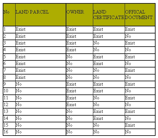
Table 1. Land-Owner-Document Condition (Haroen et al, 2005).
It is also puts on view the importance of recovery and protection of
property rights that should be conducted straight away for the following
reasons, namely recovering and protecting land property rights will lay a
solid foundation for the reconstruction work, spatial planning,
compensation, and long-term economic development. In addition, recovery and
protection of land rights are essential for establishing social justice and
ensuring a long-term social stability. Urgency of this matter is implied by
the fact that as time passes, any damaged but remaining physical evidence of
land ownership is likely to be destroyed in the general clean-up operations.
Moreover, opportunists will begin to make unlawful claim over land holdings
or rights of vulnerable and disadvantaged group. The most vulnerable groups
are widows and children who often cannot effectively defend their rights and
hence, their land could be more likely subjected to land grabbing.
The damage caused to property rights is severe. A summary of the damage
and its impact are: (i) Land Offices were severely damaged and documents
were either damaged or lost, (ii) Land Books were flooded with sea water and
mud that required immediate action for recovery; otherwise, these documents
if not treated in the next couple of months, may be irretrievably damaged,
(iii) Cadastral maps were destroyed. (iv) Only 25% of land in Aceh is
titled. Some areas have lost all physical and human evidence of ownership.
(v) There is no back up for Land Books nor the cadastral maps. It is
understood that the shortage of reliable information on land properties
needs to be overcome.
It is absolutely required that cadastral reconstruction must be able to
re-establish the acceptable locations of every land parcel in the area.
However, it is uneasy mission that definitely requires an integrated channel
of communication amongst all stakeholders: the Community, the Government and
the NGO. The sound communication will drive a strong information integration
which useable for the exercising of cadastral reconstruction in the affected
areas. The application concept of re-engineering in this matter is
unavoidable.
Therefore, the Government has taken a broad-base strategy to encourage
cooperation amongst stakeholders to assemble data sets provided by different
resources integrated into the available data base. The cooperation deals
with the remaining documents in the Government offices, geomatics data
supplied by NGO and together with the Government, and verbal information
gathered from the community (see Diagram1). The strategy development
requires coordination, cooperation and awareness across different resources.
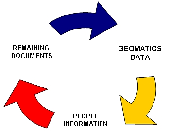
Diagram 1. Data/Information Discovery.
As a result of some of the difficulties in exercising cadastral
reconstruction, BPN as a National Land Agency started to develop a strategy
to remodel adjudication for the community, which is called CDA or Community
Driven Adjudication.
It is the needs of the user community that drive a CDA. Adjudication, as
the process where an existing right on land is conclusively and
authoritatively ascertained, is a prerequisite to legitimately be registered
in order to build a juridical relationships between people and their own
land property.
Nevertheless, despite the expectation, cadastral reconstruction through
the implementation of a modernized adjudication is forcefully dependent on
increased awareness of the people regarding the information flow on land
matters. This new strategy appears to show that cadastral model is moving
from a techno-centric to a socio-technical model of cadastral development in
order to neutralize difficulties arising from existing model. This has set
in motion the delivering of a newborn concept of cadastral model to be more
community driven.
The current activities of CDA in the field are closely linked to one or
more of the following three strategic objectives:
- Encouraging a closer cooperation amongst stakeholders by working with
other institutions including NGO and the Community to improve the quality
of cadastral services given the lack of information is a major barrier.
This strategy seeks to facilitate the diffusion of information, knowledge
and experience amongst different stakeholders
- Raising awareness of the community as a whole regarding the importance
of the people role by creating a comprehensive forum for the community
needs to discuss their problematic issues.
- Promoting the development of well-built cadastral data base by
improving the cadastral data infrastructure.
By observing the above strategic objectives, it is clear that it is the
time to introduce a new mind-set of cadastral systems. The increased role of
people as one of the stakeholders needs to be rationalized since the
Community has the supremacy to be the central of information provider.
Cadastral systems always deal with “who own what, where and area” (see
Diagram 2). The phrase of “own what, where and area” has successfully been
carried out through legal and geomatics components, leaving the phrase “who”
survive.
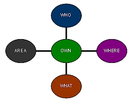
Diagram 2. Cadastral Phrase.
2. RALAS (RECONSTRUCTION OF ACEH LAND ADMINISTRATION SYSTEM)
Through a Multi-donor Trust Fund, World Bank is supporting the Government
with a US $28m program of assistance for a community-mapping program known
as Reconstruction of Aceh Land Administration System (RALAS) which will
concentrate on providing mapping for the areas that had land title
certificates prior to the tsunami. The MDTFANS or Multi Donor Trust Fund for
Aceh and North Sumatra is a partnership of the international community,
Indonesian Government and civil society to support the recovery following
the earthquakes and tsunami
The focus of the project, which has commenced in July 2005, is the
progress of community driven adjudication (CDA) (or Community Based Mapping)
for the resolution of land ownership rights, land boundaries and inheritance
reached through obtaining community agreement. To ensure consistency of
approach to CDA across the multiple agencies involved in Community based
Mapping, CDA guidelines have been prepared through a collaborative effort
involving Government, NGOs and donors.
The roles of NGOs in CDA may include:
- Facilitating community agreement on ownership and boundary demarcation
- Facilitating community-based dispute resolution
- Independent monitoring of land reconstruction
- Strengthening community institutions and decision-making processes
with special attention to the rights of women, children and orphans.
Key achievements in the recovery of property rights to date include
component A: Reconstruction of Property Rights and Issuance of Land Titles
(USD 22.10 million) and component B: Reconstruction of BPN Institutions in
Aceh (USD 3.9 million). Component C: Project Management (USD 2.5 million)
RALAS reported that prior to the fasting month of Ramadhan up to 25,000
land parcels have completed community land mapping. This represents about 60
villages in Banda Aceh, 20 villages in Aceh Besar and 20 villages in other
districts in Aceh.
In August 2005, BPN deployed its RALAS Project Implementation Unit (PIU)
to Aceh and by early September had deployed 200 personnel (10 adjudication
teams). In early October, these teams were deployed to the field to start
officially surveying and adjudicating completed community land mapping
(Photo 3).
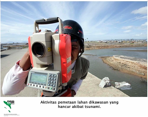
Photo 3. Mapping activities in affected areas of tsunami
In close cooperation with relevant stakeholders, the Manual for Community
Driven Adjudication (CDA) was completed on June 10, 2005. This manual has
been issued by BPN as a decree. BRR or Badan Rehabilitasi dan Rekonstruksi
(Rehabilitation and Reconstruction Agency) has also prescribed the CDA
Manual as a standard for reconstruction. It is now being used by all trained
facilitators supporting shelter projects as the standard for community land
mapping. At least 600 facilitators have already been CDA trained. UNDP has
committed to training almost 750 facilitators.
According to BPN it can be expected that on October 26, BPN will issue
Public Notification for the first 1,500 land parcels in Banda Aceh (1000)
and Aceh Besar (500). Providing there are no objections, land titles for
these parcels will be available for distribution to beneficiaries in about 6
weeks (30 days for public notification and 2 weeks for documentation
preparation). It is planned that the titles could be distributed on December
20, 2005, subject to the issuance of the Government Regulation to waiver
land registration taxes, fees and charges.
By December 31, 2005 RALAS expects that up to 30,000 parcels of land will
have completed community land mapping. Currently, adjudication teams are
ill-equipped. If additional equipment becomes available soon, BPN
anticipates a maximum of 12,000 land parcels will have land titles ready for
distribution by December 26. If equipment is further delayed, a maximum of
only 7,500 land titles can be expected for distribution.
Up to 600 personnel have been trained in CDA, comprising of 400 NGO land
mapping facilitators and 200 BPN employees that conduct the adjudication
process. Some computing and surveying equipment has been purchased to enable
BPN to undertake land adjudication (one computer and one set of equipment
per team). Further purchase will significantly increase speed of
adjudication and land titling. It is targeted that up to 2009 cadastral
reconstruction should successfully be completed for 600,000 land properties.
Up to today, the exercising of cadastral reconstruction in all affected
areas is still on progress. Various issues exist in the field encompassing
technical and non technical. This is a stressful responsibility that all
stakeholders are facing with.
3. CONCLUSION
A newborn model of adjudication has been put in force due to the urgent
demand to re-establish cadastral datasets of land ownerships in the affected
areas. Post disaster reinforces the importance of having awareness from all
stakeholders of the challenges and issues involved in exercising cadastral
reconstruction. This awareness is the spirit in delivering the new model of
cadastral systems to be more people oriented, in harmony with the changing
nature of communities and their needs related to their land property.
As a result, post disaster, a closer relationship amongst the Government,
Community and Non-Government Organizations is enormously accomplished. This
is the center of attention in reformatting the cadastral mind-set.
It is the right time for all cadastral societies world-wide to re-design
the format of current cadastral approaches. It is now an era dynamic
cadastral systems that its deliveries should be more community-driven and
promoted to be more focus to the people as the core stakeholder.
It is hoped that the precious lessons taken from the tragedy generate new
thoughts and paradigms to liven up cadastral mind-set all over the world.
This would be valuable contribution to the growing world of cadastral
knowledge and sciences.
May God bless all of us.
Aamiin.
REFERENCES
Haroen, T.S., Herryani, E.S., Hidayat, A.N., 2005, Cadastral
Reconstruction in Aceh, Presented at the MAP ASIA 2005 Conference, Hotel
Mulia Senayan, Jakarta, 22-25 Agustus 2005.
http://www.mdtfans.org/index.html,
Multi Donor Trust Fund for Aceh and North Sumatra.
http://www.mdtfans.org/p-land.html,
Multi Donor Trust Fund for Aceh and North Sumatra.
http://www.reliefweb.int/library/document/2005/wb-idn-25jun.pdf,
RALAS (Reconstruction of Aceh Land Administration System).
http://e-aceh.bappenas.go.id/pledge/file/may10,2005,
Proposal for Recovery of Property Rights and Reconstruction of Land
Administration System.
CONTACTS
Tony S. Haroen, Chairul B. Achmad and Wenny Rusmawar
National Land Agency / Badan Pertanahan Nasional
Indonesia
E-mail: tony_s_haroen@yahoo.com
and rusmawar@cbn.net.id
 |


