Article of the Month -
June 2014
|
THE GREAT WALL OF CHINA:
The World’s Greatest Boundary Monument!
John BROCK, Australia
1) This paper investigates
which portions of The Great Wall(s) of China were mainly erected as
boundary demarcations and the others put up as protection as well as
attempting to highlight early techniques and equipment used by the
Chinese surveyors of antiquity hopefully supplemented by some translated
texts and historic art. The paper will be presented Friday 20 June 2014
at the History Symposium held in conjunction with the 2014 FIG Congress
in Kuala Lumpur Malaysia. The History Symposium is organized by the
International Institution for the History of Surveying and Measurement,
a Permanent Institution within FIG,
http://www.fig.net/fig2014/history.htm.
ABSTRACT
”… in the endeavors of mathematical surveying,
China’s accomplishments exceeded those realized in the West by about one
thousand years.”
Frank Swetz – last line in The Sea Island Mathematical
Manual: Surveying and Mathematics in Ancient China.
It is said that the Great Wall of China is the only
manmade structure on Earth which is visible from space (not from the
Moon)! The only natural feature similarly identifiable from the outer
reaches past our atmospheric zone has been named as Australia’s Great
Barrier Reef. This natural wonder of the sea is continuous while the
Great Wall of China is actually made up of a series of castellated walls
mainly erected along ridge lines causing major variations in the levels
of its trafficable upper surface. Some of the barriers built are not
formed from stone but from rammed earth mounds.
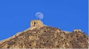
Fig. 1 The moon from The Great Wall instead of
vice versa which cannot actually occur !!!
The purpose for these walls was primarily to
facilitate protection from hostile adjoining tribes and marauding hordes
of enemy armies intent on looting and pillaging the coffers of its
neighbouring wealthier Chinese Dynasty of the time. As the need for
larger numbers of military troops became required to defeat the stronger
opponents, which may sometimes have formed alliances, the more astute
provincial rulers saw a similar advantage in the unification of the
disparate Chinese Provinces particularly during the Ming Dynasty
(1368-1644). In fact the earlier sections of the Great Wall(s) were
constructed to delineate the territorial areas of separately governed
principalities thus representing some of the most ancient continuous
boundary monuments of substance still surviving to this day. This paper
will investigate which portions of The Great Wall(s) of China were
mainly erected as boundary demarcations and the others put up as
protection as well as attempting to highlight early techniques and
equipment used by the Chinese surveyors of antiquity hopefully
supplemented by some translated texts and historic art.
INTRODUCTION
When it comes to the imagination of world peoples The
Seven Wonders of the World holds curiosity of conversation usually when
called upon to name any series of such groups of seven including dwarfs,
deadly sins and so on. Due to the magnitude of its extent The Great Wall
of China quite often is put forward (wrongly) as one of these seven
man-made constructions of amazement. Erected over a vast expanse of
history the “Chinese Wonder” is certainly one of the most visited
edifices by modern tourists but what is available for public viewing is
a mere fragment of the actual 21,196 kilometres of the overall lineal
coverage of the various features included among what has become known as
The Great Wall. Only in the last few years from 2007 has this survey
accurate total been determined through a joint project by China’s State
Administration of Cultural Heritage and the State Bureau of Surveying
and Mapping with the existing previous estimate at that time being less
than half of the true length at a mere 8,850 kilometres ! From the
popular perception the section of The Wall built of stone in the
vicinity of Badaling, near Beijing, has become the vision most
representative of this iconic structure due to its substantial material,
excellent restoration and open accessibility for viewing. Although the
steeply disparate levels of the Wall’s floor area make movement rather
difficult the public authorities responsible for its maintenance and
availability have had handrails installed to assist visitors to pull
themselves up the demanding slopes. My thoughts instantly pondered as to
how the heavily clad Chinese warriors could possibly negotiate such
forbidding barriers of non-evenness as those existing along most of The
Wall where it stood imposingly atop ridgelines separating the northern
territories from the Chinese lands to the south. Then of course, being
the inquisitive surveyor that I am, my next immediate thought was that
how this famous line of walls actually separated the land of one peoples
from those occupied by a rival nation thus being a visible boundary
monument for the delineation of designated lands. By sheer definition
both physically and notionally a wall is erected to “divide” one area
from another thus representing a barrier or borderline across which
incursions are only welcome by invitation or imposed by the invasion of
one neighbour onto the territory of the other. Surveyors always find
fascination and interest in boundary lines with particular attention
directed to what has been placed to define such lines of territorial
demarcation so along with concern about boundary markers comes a
consideration of who actually placed them and how they were surveyed.
Uncovering source material about the ancient Chinese surveyors has not
been easy due to the language barrier between English and Chinese as
well as the long periods of banishment of foreign inquisition and
examination imposed by the Imperial Chinese decrees of isolation
intended to maintain the non-contaminated superior Chinese lifestyle.
However my determination has paid off through my discovery of a
brilliant English text by Professor Frank J. Swetz on Chinese
mathematics as it so pertains to surveying purchased from the
Pennsylvania State University Press via the internet for a very
reasonable fee which also included packaging and postage. The much
anticipated publication arrived in very quick time indeed !
CHINA’S GREAT SURVEYORS
|
“The Sea Island Mathematical Manual:
Surveying and Mathematics in Ancient China” by Frank J. Swetz is
an examination of a Chinese teaching text called the Haidao
Suanjing (translated as the Sea Island Mathematical Manual)
compiled in 263 AD by Liu Hui, an official during the Kingdom of
Wei (220-290 AD).also known as the Three Kingdom Period, being a
somewhat unsettled time under the reign of an emperor named Cao
Pei. Nine problems associated with varying situations of field
surveying are solved using the application of right angled
triangles confining such hypotheses to micro-scale land areas
within which the subject areas can be assumed to be planar and
thus unaffected by any considerations of earth curvature or such
spheroidal nuances. In the earliest known Chinese mathematical
text the Zhoubi Suanjing (translated as Perimeter Gnomon
Manual), published between 100 BC and 100 AD, the material
published represents established surveying practices including
accomplished application of right triangle theorem in operation
for hundreds of years. With this long history in mind the period
mentioned clearly covers the lifetimes of the legendary Grecian
Fathers of Geometry Thales (624-527 BC) and Pythagoras (569-475
BC) so the level and extent of mathematical knowledge and |
 |
|
accomplishment of the Chinese is truly
remarkable indeed. To clarify the subjects covered in this
ancient corpus of knowledge it is necessary to define “zhou” as
“perimeter” and “bi” as “gnomon” being a shadow staff for
position reckoning by the sun. Also employed by the Chinese was
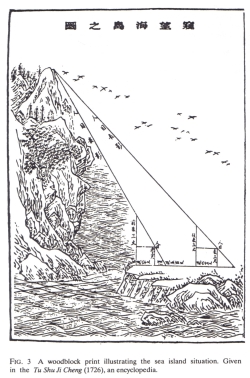
the set square (ju) to determine the heights of remote objects
through the proportional geometry of triangles (see Figure 3).
To measure distance the ancient Chinese mensors used the
customary rope which in more recent times was replaced by tapes
and long wires supplemented with the use of plumb bobs for line
propagation and horizontality. |
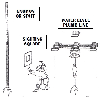
Fig. 4 Chinese surveying equipment of the ancients.
Surveying tools from ancient China are well testified
through artwork, artifacts and descriptions being sighting or reference
poles (gnomons), biao; set square, ju; plumb line, xian; water level,
zhun, ropes and cords later replaced by tapes, bu che. As more commonly
known in English as “The Arithmetical Classic of the Gnomon and the
Circular Paths of Heaven” dated to circa 100 BC - 100 AD, it takes the
form of a discussion between Zhou duke Zhou Gong and a Grand Prefect
called Shang Gao when the nobleman asks of the official: “May I ask how
to use the set square?” to which the response comes: “Align the set
square with the plumb line to determine the horizontal, lay the set
square down to measure height, reverse the set square to measure depth,
lay the set square down to determine distance. By revolving the set
square about its vertex a circle can be formed, combining two set
squares forms a square.” (see Figure 5) The length standards and
languages adopted were quite variable before Emperor Zheng took power in
221 BC after defeating the provinces of the weaker leaders to earn the
title of The First Emperor. Through his rigidly despotic regime he
introduced a single currency, standards for weights and measures as well
reducing the alphabet down to a mere 3,000 characters in a single spoken
dialect ?!? Putting into practice the new specifications of mensuration
surveying devices were made to differing lengths depending on the
accuracy required, with sighting poles quoted to be 20 and 30 chi
respectively in the problems of the Haidao being the equivalent of 7 and
10.5 metres. The standard Chinese set square for field use had sides of
2 chi (0.7 metre) but could be made to lengths of 12 or 23 chi plus (4.2
or 9.1+ metres) to achieve finer results.
The Haidao Suanjing was the mathematical aid to solve
the field problems which confronted the surveyors consisting of nine
individual circumstances summarised as:
-
The sea island problem to calculate the
height of a remote island;
-
The pine tree problem to ascertain the
height of a distant tree;
-
Size of a distant walled city problem;
-
Depth of a ravine problem;
-
Height of a building as viewed from a
hill problem;
-
Width of a river mouth problem;
-
Depth of a clear pool problem;
-
Width of a river problem an
-
Size of a city from above problem.
|
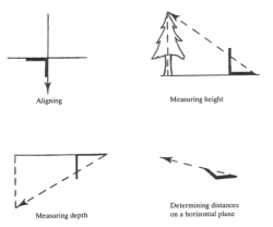
Fig. 5 Set square measurements as per
some from The Haidao Suanjing. |
Considering Chapter Nine of this contemporary text to
be inadequate for precise measurements Liu introduced a method of
calculation called chong cha (translated as “double difference”), a
concept well understood and employed by all prudent surveyors as a
mechanism to compensate for systematic errors present in monitoring
equipment being readily eliminated by repeat observations at 180 degree
orientation.
The essential work of the surveyors in Imperial China
was directed towards the four purposes as listed:
-
Mapping required for the existence and
maintenance of the political state;
-
Verification of cadastral land boundaries for
ownership and taxation;
-
Supervision of public works such as roads,
aqueducts and canals and
-
Warfare reconnaissance and target assessment.
Such considerations are elements of all the great
civilizations in their expectations and demands upon their land
surveyors with particular recognition of the skill and authority
demonstrated by the ancient Egyptians, Greeks and Romans. From the most
ancient Chinese classics instructions pertaining to waging war contained
references to the vital need for accurate mapping and techniques to
determine the position of the enemy from satellite posts. From before
the Qin Dynasty (221-206 BC) such as Zhou Dynasty (1025-256 BC) classics
as the Zhou Li (Rites of the Zhou Dynasty), Zhan Guo Ce (Records of the
Warring States), Guan Zi (The Book of Master Guan), Sun Zi Bing Fa
(Master Sun’s Art of War – 5th century BC) and Sun Bin Bing Fa (Sun
Bin’s Art of War – 4th century BC) the existence and use of maps were
cited on many occasions.
SURVEYING IN CHINESE MYTHICAL LEGEND
As far back as around the 29th century BC Chinese
mythology has an event supporting a Noah’s Ark Biblical epic of a Great
Flood which wiped out the world with the only survivors being Fu Xi and
his wife (who may also have been his sister?) Nu Wa who held equal
status with her husband in Taoist tradition for repopulating the Earth
with the tools of creation – the compass and set square! It is indeed
prophetic for the future surveyors of China that these two instruments
of myth would become their own devices for carrying out their survey
tasks. Fu Xi is variously said to have ruled as “The First Emperor” (of
folklore!) for over 115 years commencing in either 2952 or 2852 BC. As a
folk legend this guy had everything useful to a surveyor in the wild
bush land as he was said to have been a shaman who could tame wild
creatures as well as being capable of controlling the weather.
Furthermore he is credited with inventing many things among which were
cooking, trapping, fishing, music, writing, the calendar and angle
measurement! When images of Fu and Nu are shown Fu holds the compass and
Nu the set square with their snake-like bodies intertwined. This pair
would appear to me to represent an archetypal couple of Surveyor Gods to
which the later surveyors may have called upon for heavenly guidance
during their surveying assignments.
MAPS FROM ANTIQUITY
During 1973 an archaeological dig of a Han Dynasty
tomb at Mawangdui in the south west region of Changsha discovered three
silk maps of a marquisate dated to the Western Han period (206 BC to 6
AD). One of the silken charts was drawn at an approximate scale of
1:180,000 depicting mountain ranges, rivers, occupied areas and
topographical features with contours. Through a comparison with a modern
map of the same area it was very clear that the surveyors and
cartographers who contributed to the historic work must have been
capable of reliable and highly precise map production. One of the charts
was prepared to plot troop locations within the designated mapping zone.
Regarded as the Father of Chinese Cartography Pei Xiu
(AD 223-271) was made Minister of Works in 267 by the first emperor of
the unified Jin Dynasty (265-316). He assembled all known cartographic
works at that time postulating the following set of six principles for
good map making:
-
The use of an appropriate scale in drawing;
-
The employment of a rectangular grid system;
-
Accurate measurements between major landmarks
including the projection
onto a plane of those with different elevations precisely executed;
-
Determination of accurate elevations;
-
Measurement of right and acute angles and
-
Measurement of curves and straight lines.
As each of the pronounced principles required a
working comprehension of the use of right angled triangles
mathematically it formed the basis of the Chinese surveying and
cartographic process for the facilitation of the surveying and
preparation of most reliable and impressive maps from the mysterious
empire. Military needs were the not the only area to which such
standards of precision and accuracy were applied by the Chinese
autocracy. Due to the common occupation of areas adjacent to or nearby
to rivers and estuaries careful planning was carried out to design civil
works for the diversion of waterways through canals and irrigation, all
of which demanded a high level of correctness and skill to make
preliminary reconnaissance surveys followed by the precision necessary
to construct such intricate systems of water utilisation. Such respect
was held for the surveying skill commensurate with the very survival of
the populace translated onto the godlike qualities of the revered
leaders of China when the legendary emperor/engineer Yu the Great
(c.2200-2100 BC, Xia Dynasty) (also often depicted with a set square in
hand!) was described in the following way:
“Emperor Yu quells the flood, he deepens rivers and
streams, observes
the shape of the mountains and valleys, surveys the high
and low places,
relieves the greatest calamities and saves the people from danger. He
leads the floods east into the sea and ensures no flooding or drowning.
This is made possible because of the Gougu right triangle theorem.”
During early periods the term for astronomers and
surveyors were exactly the same, chou jen or literally “surveyors of
heaven” which clearly portrays the divine status bestowed upon China’s
ancient surveyors.
EMERGENCE OF THE WALL
Prior to the unification made under Zheng’s
dictatorship in 221 BC China consisted of a diverse group of what was
termed The Warring States mainly focused on the preservation of their
limited principalities from the territorial ambitions of their various
not-so-friendly neighbours. Thus the first series of boundary walls were
erected as defences for their own individual bits of turf, therefore
truly being boundary monuments by design. This earlier epoch was known
as the Zhou Period but was comprised of Qin, Zhao and Yan States who put
up their walls of separation for both protection and demarcation from
350 to 215 BC.
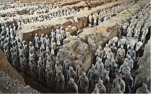
Fig. 6 The First Emperor’s heavenly guards in his spectacular burial
place in Xian.
However when Zheng took over domination of the
disparate factions he soon embarked on what history has declared to be
the commencement of Great Wall construction with the express purpose of
keeping at bay the hostile tribes to the north of this structure and in
so doing created the physical delineation of his Qin Dynasty empire in
the northerly direction. Within the relatively brief reign of just over
a decade up until 210 BC upon his death, The First Emperor had been
successful in constructing some 4,000 miles (6400 kms) of the first
Great Wall in addition to creating the other major tourist attraction of
modern China – The Terracotta Warriors guarding his tomb at Xian.
Contemporary accounts during the construction of this megalomaniacal
monument give an estimate of around 7,500 entombed statues of which only
1,000 have so far been uncovered for public viewing.
|
Extending from the Ordos ranges in the west
right through to the coast in the east this rather humble wall
in its height and substance had been the inspiration for later
rulers to build similar barriers but with more durable and
impressive material along some of the most inhospitable terrain
and precipitous ridgelines across the mainly northern area of
the Chinese empire. As this first attempt at a “Great Wall” was
clearly not impregnable to armies of horse cavalry as they only
stood at heights of 1 or 2 metres for the majority of its length
without ramparts or towers it was the mere concept of a physical
symbol to convey the message to any potential invader that to
pass across this boundary would invoke dire repercussions by the
Chinese Imperial Forces and thus it was a most emphatic border
delimitation. It is interesting to note that this “first”
attempt at a “Great Wall” was punctuated along its length by
beacon towers or pillars which were clearly placed |
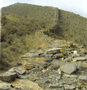
Fig. 7 The First Emperor’s “Great Wall” boundary monument. |
|
for determining strategic locations or other
troop position points. Could they have also been utilized by the
surveyors for mapping and surveying activities? It is a
tantalising notion indeed! |
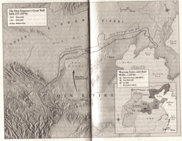
Fig. 8 The First Emperor’s northern boundary line as delineated by the
first “Great Wall”
The two Han Dynastic Periods from 202 BC to 220 AD
saw the western extension of this Wall. From this time onwards more
local walls were erected from 220 to 1234 while during the domination of
the Mongols from 1234 to 1368, the latter under the leadership of the
mighty Genghis Khan himself for a period, the Wall was left to natural
decay and dilapidation until the rise of the mighty Ming Dynasty.
Probably more well-renowned for its treasured blue
and white ceramics the Ming Dynasty was much more than just a ruling
class of potters. After crushing the Mongol Army in 1368 the Ming
leaders could not have imagined that their dynasty would prevail right
through until 1644 when they were out-manoeurvred by the Manchus whose
reign is called the Qing Dynasty lasting until 1911.The modern populist
vision of a Great Wall of stone with crenellated ramparts and beacon
towers running along the mountain tops as far as the eye can see is owed
to the work of the Mings whose capital works program included this
monumental construction. Their intentions certainly were to fortify and
protect their territory and citizens from the ravaging marauders but by
placing their walls along ridge lines which were already natural borders
separating two different tracts of land they had unintentionally set
about placing the most famous and impressive boundary monument ever
created by man on earth.
During war and peace the Ming kept on building their
wall despite much dissension about the cost of such a capital works
program when other areas were considered to be deserving of more
priority. However up until 1568 there were still many defensive gaps in
the wall and hardly any beacon towers of note at all. All was soon to
undergo major improvement in these areas at the behest of one of China’s
heroes named Qi Jiguang who became the principal architect of the Great
Wall in its iconic modern image of the grandest of designs. With an
upbringing which indoctrinated discipline, loyalty, martial arts,
philosophy and dedication Qi, at the age of forty, was entrusted with
the duty to reinforce the northern wall to a military standard against
the perceived northern savages. Embracing his assignment with
enthusiastic zest Qi knew exactly how and what he was intending to
achieve but as has been the custom from time immemorial the Imperial
Treasury forced him to rein in his grandiose ideas with his desired
3,000 forts reduced to 1200 of which only 1017 were actually built. Any
appeals for urgency to construct Qi’s reinforcements greatly dissipated
after the treaty with Altan in 1571. Nevertheless the resourceful
soldier was able to exploit the paranoia of the bureaucratic officials
convincing them that there was no better time to prepare for war than
during peace time so the substantial construction scheme was allowed to
carry on in earnest. Finally taking around ten years to come to fruition
Qi had ultimately succeeded in facing the existing Qin Wall with bricks
and stone while turning the top of the structure into a paved roadway or
trafficable stepped areas where slopes became too inclined. This roadway
was to be crenellated for protection while under assault as well as
being punctuated with forts standing on blocks 10 to 15 metres (3-4
storeys) above the Wall itself each accommodating up to 50 men together
with food and ammunition. Qi’s Great Wall was a fully self-contained
interactive defensive network which was never actually subjected to any
engagements to practically test its effectiveness so the Chinese legend
had created the future symbol of China without realising that it would
never be utilised for the purpose for which he had so systematically
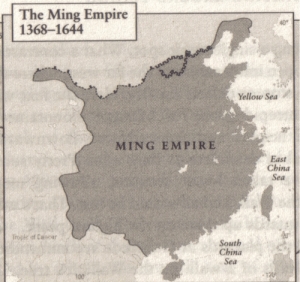
devised it. As can be seen from the map of the Ming Dynasty this
magnificent Great Wall creation did indeed follow the northern boundary
of the territorial limits of the Ming Empire easterly as far as the
ocean at Shanhaiguan.
|
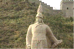
Fig. 9 (left) Qi Jiguang’s statue proudly standing within
view of his greatest project – The Great Wall
Fig 10. (right) The Ming Empire 1368-1644 |
 |
For a long period after the Manchu conquest of the
Mings in 1644 the dynasty known as the Qing once again subjected the
Great Wall to abject neglect and inattention right up until 1911 being
over 260 years of the abrogation of required maintenance. Even between
1911 and 1949 there was a negligible effort to restore China’s iconic
symbol of the nation’s historical accomplishments. It was left to the
Communists from 1949 until the current day to set about an extensive
renovation of Qi’s magnificent edifice. Through the very recent actions
of the State Administration of Cultural Heritage not only has the wall
been refurbished but two more areas at Huanghuacheng and Hefangkou have
been prepared for touristic inspection to provide even greater
accessibility to this marvel of Chinese civil construction. Both of the
existing viewing sites at Badaling and Mutianyu have also been upgraded
in the latest improvements to further demonstrate China’s enthusiasm to
show off their legendary monument to the rest of the world.
 |
 |
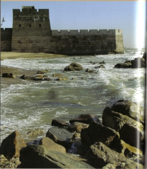
| Fig. 11 THE GREAT WALL
FROM THE SKY
...TO THE SEA |
 |
CONCLUSION
My journey of discovery into the surveyors of ancient
China combined with the fascinating epic tale of the history of the
Great Wall of China has given me an incredible appreciation for the
brilliance of the great surveyors and engineers of the Imperial Eastern
civilization. My Homeresque revelation of the mythological figures of
Chinese folklore whose symbols were to become the future measuring
devices for the surveyors of yore was most exciting and very surprising
along with the amazing echelons of mathematics and measurement that were
achieved by this covert culture.
REFERENCES
Harrison-Hall, Jessica, The British Museum Pocket
Timeline of China, (The
British Museum Press, Malaysia 2008)
Man, John, The Great Wall – The extraordinary history
of China’s wonder of
the world, (Bantam Books, Transworld Publishers, London 2009)
Swetz, Prof. Frank J., The Sea Island Mathematical
Manual: Surveying and
Mathematics in Ancient China, (Pennsylvania University
Press, USA 1992)
JOHN BROCK CURRICULUM VITAE 2014
Private land surveyor since 1973, Bachelor of
Surveying from Uni. of NSW (1978), MA from Macquarie Uni., Sydney
(2000). Now Director of Brock Surveys at Rosehill (near Sydney). Papers
presented all over world inc. Egypt, Germany, France, Hong Kong, Canada,
Brunei, New Zealand, Greece, UK, USA, Israel, Sweden, Morocco, PNG,
Italy and Nigeria. Since 2002 regular column Downunder Currents in Royal
Institute of Chartered Surveyors magazine (London) Geomatics World.
Institution of Surveyors NSW Awards – Halloran Award 1996 for
Contributions to Surveying History and 2002 Professional Surveyor of the
Year. Contributor to FIG Institution for the History of Surveying and
Measurement awarded FIG Article of the Month March 2005 for “Four
Surveyors of the Gods: XVIII Dynasty of New Kingdom Egypt (c. 1400 BC)”
and FIG Article of the Month January 2012 for “Four Surveyors of Caesar:
Mapping the World.” First international Life Member of the Surveyors
Historical Society (USA), Life Member of Rundle Foundation for Egyptian
Archaeology and Parramatta & District Historical Society, Foundation
Member Australian National Maritime Museum and Friends of the National
Museum of Australia, Member of RAHS, National Trust of Australia, Hills
District Historical Society, Prospect Heritage Trust, International Map
Collectors Society and Friends of Fishes (Canowindra).
CONTACTS
John Francis Brock
P.O. Box 9159,
HARRIS PARK NSW 2150, AUSTRALIA.
Tel: 0414 910 898 Fax: +61 (0)2 9633 9562
E-mail:
brocksurveys@bigpond.com
 |