Key words: cadastre, modelling, LADM, INSPIRE
SUMMARY
Efforts are currently made to develop models for transferring
cadastral information at international level. For this purpose
harmonization of national models, at least the core objects, is
required. In Europe, INSPIRE theme Cadastral Parcels has introduced a
model for cadastral spatial data. Work with a wider perspective is
currently taking place as ISO work, where the objective is to provide an
international standard for the information used in land administration
(Land Administration Domain Model, LADM).
Finland has participated in both processes. This paper briefly
presents the Finnish cadastre and the concepts of basic property unit,
parcel and right-of-use unit. The implementation of the INSPIRE
Cadastral Parcels model in Finland is analyzed. The LADM conceptual
model has been examined by making a pre-analysis how the concept of
right-of-use unit fits into the LADM model. Finally, the experiences of
the work - both international cooperation and implementation at national
level - are described.
1. INTRODUCTION
Efforts are currently made to develop models for transferring
cadastral information at international level. For this purpose
harmonization of national models, at least the core objects, is
required. This poses new challenges for the development at national
level.
In Europe, INSPIRE theme Cadastral Parcels has introduced a model for
cadastral spatial data. Directive 2007/2/EC of the European Parliament
and of the Council of March 2007 establishing an Infrastructure for
Spatial Information in the European Community has caused a lot of work
for implementing the rules of the directive. Cadastral parcels were
included in the work. This work has focused on the geographical part of
cadastral data. The INSPIRE model is binding and the data product
specification has to be implemented at national level for INSPIRE
information service.
Work in a wider perspective is currently taking place as ISO work
(ISO 19152), where the objective is to provide an international standard
for the information used in the land administration domain. The emphasis
is on the particular part of land administration that is interested in
view of rights, responsibilities and restrictions affecting land and
water and the geometry thereof. The Land Administration Domain Model
(LADM) is currently in progress and is to become an international
standard. The LADM model is a conceptual model and not a data product
specification.
Finland has taken part in both processes; in INSPIRE as a member of
the thematic working group Cadastral Parcels and also in testing and
commenting, and in LADM as a participant in the work of the project team
and the editing meeting as well as in commenting.
This paper concentrates on data modelling with the terminology used
in modelling.
2. BACKGROUND AND DEFINITIONS USED IN THIS PAPER
In Finland all cadastral information - both map data and attribute
data - are registered in one integral database (started in 1998 and
renewed in 2005) managed by the National Land Survey of Finland.
Surveyors working at the National Land Survey and in certain
municipalities are responsible for carrying out legal surveys, measuring
data and registering it in the database. The system has been renewed and
expanded in 2005 and during that time, it was modelled thoroughly with
UML figures, and XML/GML schemas for data transfer were introduced.
The main objects in the cadastre include basic property units,
parcels, boundaries and right-of-use units. Transactions are also
recorded in the register. Also information on ceased units is preserved.
The history of geometry is maintained as simple geometry. All geometry
is currently 2-dimensional.
The Official Purchase Price Register is integrated into the cadastre.
Since the beginning of 2010 The National Land Survey has been
responsible for registering titles and mortgages but this particular
database is separated from other registers and will be renewed.
2.1 Concept of basic property unit and parcel according to the
Cadastral Acts
A basic property unit is the basic unit in registration and it is
provided with a unique identifier. The unit consists of one or several
single areas (parcels) which are not provided with unique identifiers.
In some cases a basic property unit can be registered without an actual
area and only have shares in common areas.
The whole country (land and water) is divided into parcels. Public
areas are also included. Some minor areas are found in between which are
to be renewed. The cadastral map is an index map. The measurements etc.
are found in cadastral survey maps which are stored with other cadastral
survey documents nowadays in digital archives. See the concept in Figure
1.
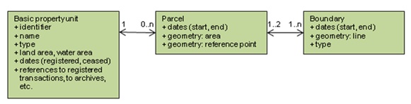
Figure 1 Concept of a basic property unit and
a parcel with main objects and main attributes
2.2 Concept of right-of-use unit according to the Cadastral Acts
Rights and restrictions defined in Cadastral Acts must be registered
(since 1998) as right-of-use units. Both users and developers have
considered this concept as very successful.
Different types of right-of-use units are defined in Acts, e.g.
rights and restrictions defined in the Real Estate Formation Act
(private roads, wells, landing places for boats etc.), in the Land Use
and Building Act (building easements etc.) and other Acts (private
roads, fishing restrictions, protected areas, mining rights,
restrictions according to Highways Act and Railway Act, snowmobile
driving routes etc.).
Every right-of-use unit is provided with a unique identifier.
Right-of-use unit can be composed of one or more sub-units. With some
exceptions (e.g. private graves under private data protection)
right-of-use units have to be located on the cadastral map and the
location of the sub-units (area, line or point) is registered. Also the
information of the right holders and the restriction objects are
registered for the sub-units.
Figure 2 shows the case of typical servitudes. The basic property
unit A needs a well for taking water for household consumption. This
well is located inside basic property unit B and the water pipe is
located in three basic property units (B, C and D). These rights are
registered as two right-of-use units with one sub-unit: one for the well
as a point (W) and one for the water pipe as a line (P). The right
holder for both units is basic property unit A. The restriction object
for W is B. The restriction objects for P are B, C and D.
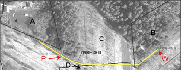
Figure 2 The case of two servitudes (a well
and a water pipe)
Rights and restrictions are registered in most cases between basic
property units (never between the owners of the basic property units).
In some cases, the right holder can be a juridical person, like a
municipality e.g. with a sewer network or an energy company with an
energy network. In very few cases the right holder is not registered
(e.g. public road maintaining cases where the right holder is obvious).
The restriction objects are always basic property units and not
parcels (parcels are not registered with identifiers). The restriction
objects are registered in the database with date and transaction etc.
information which makes it possible to easily to register and change the
information on each relationship and also to store the history of
changes.
In some rare cases the right holder and the restriction object cannot
be separated (some building easements) and they are technically
registered as participants.
The overlay of geometry is used during the registration process to
help recognizing the restriction objects. Otherwise overlay is not used.
The problem with overlay is that it does not always provide the correct
information, e.g. the locations are not always registered with the same
accuracy. It is not possible to store relationship information as
overlay provides only temporary information. Overlay is for example
suitable for calculating values but not for dealing with legal rights
and with liability of damages by incorrect registration. In information
services overlay can be slow for producing the required data.
The concept of right-of-use unit is shown in Figure 3.
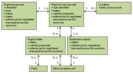
Figure 3 Concept of right-of-use unit with
main objects and main attributes
Figure 4 shows the case of a right-of-use unit for a protected site.
Right-of-use unit identifier is 000-2005-K3874. It includes two
sub-units and the restriction object is the basic property unit
146-406-1-44. The environmental authority provides the data, not the
cadastral registry. Thus, the responsible authority, the date of the
original decision and the archive reference are also registered.
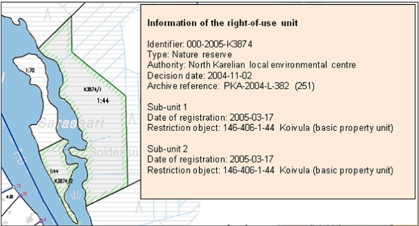
Figure 4 The case of a right-of-use unit for a
protected site
3. EUROPEAN MODEL
3.1 Cadastral Parcels model in INSPIRE
The INSPIRE work has focused on the geographical part of cadastral
data. The purpose is to use it as reference data for other information
belonging to a specific thematic field such as environment, soil, land
use etc.
Harmonising the concepts of ownership and rights related to the
parcels are not included in the scope of INSPIRE. The attribute national
cadastral reference which is included in the model can be used at a
national level to obtain information from national data sources
according to national legislation. Buildings, land use and addresses are
included in other INSPIRE themes.
INSPIRE Cadastral Parcels model consists of four spatial object
types: cadastral parcel (the core object, basic property unit, cadastral
zoning and cadastral boundary. Figure 5 shows the model.
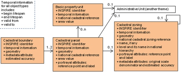
Figure 5 Spatial object types and associations
between them in the INSPIRE Cadastral Parcels model
Definitions of the spatial object types are the following (from the
Data Product Specification of Cadastral Parcels):
Cadastral parcels are defined in the INSPIRE Directive as
“areas defined by cadastral registers or equivalent”. As much as
possible, in the INSPIRE context, cadastral parcels should be forming a
partition of national territory. Cadastral parcel should be considered
as a single area of Earth surface (land and/or water), under homogenous
real property rights and unique ownership, real property rights and
ownership being defined by national law.
Basic property units are the basic units of ownership that are
recorded in the land books, land registers or equivalent. They are
defined by unique ownership and homogenous real property rights and may
consist of one or more adjacent or geographically separate parcels. In
the INSPIRE context, basic property units are to be used by countries
where unique cadastral references are given only for basic property
units and not for parcels. Basic property units allow these countries to
provide information about area or about temporal validity in the
cadastral registers.
Cadastral zonings are the intermediary areas
(such as municipalities, sections, and blocks) used in order to divide
national territory into cadastral parcels. In the INSPIRE context,
cadastral zonings are to be used to carry metadata information and to
facilitate portrayal and search of data.
Cadastral boundary is defined as a part of the outline of a
cadastral parcel. In the INSPIRE context, cadastral boundaries have to
be made available by European Union Member states where absolute
positional accuracy information is recorded for the cadastral boundary.
3.2 Implementation of the INSPIRE Cadastral Parcels model in
Finland
INSPIRE obligates to provide information service, where the
transformation file format is harmonised. Parcel is the core object in
the model. The INSPIRE information service in Finland can be summarized
as follows: transferring valid parcels and the information of the basic
property units related to them. See Figure 6.
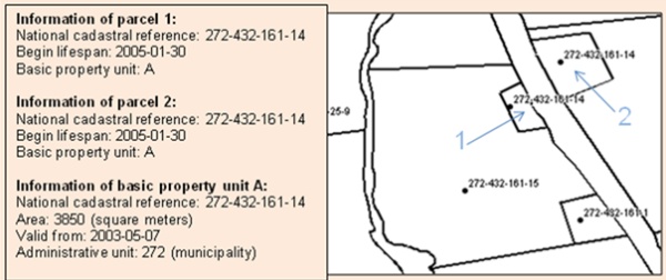
Figure 6 Example of the portrayal of Finnish
cadastral data in the INSPIRE data model
Cadastral parcel and basic property unit are the object types which
will be provided. The provided attributes for parcel include the INSPIRE
identifier, national cadastral reference, begin lifespan, geometry and
reference point with a label. The attributes provided for the basic
property unit include the INSPIRE identifier, national cadastral
reference, area value and validation date. In addition the association
from parcel to the basic property unit and the association from basic
property unit to administrative unit will be provided.
Finland will not provide cadastral zonings because no zonings within
the scope of INSPIRE exist. Finland will not provide cadastral
boundaries because the estimated accuracy is recorded only for cadastral
points and not for cadastral boundaries.
4. INTERNATIONAL MODEL
4.1 Land Administration Domain Model
Land Administration Domain Model (LADM) is a reference model. It
provides terminology for land administration which can be used in
different formal and informal practices and procedures in various
jurisdictions. One purpose is to provide a basis for the development and
refinement of efficient and effective land administration systems.
Another purpose is to enable countries involved to communicate using a
jointly shared vocabulary implied by this model.
LADM is a conceptual schema and it consists of objects which model
parties, basic administrative units and spatial units as well as
associations between them, which in turn consist of rights,
responsibilities and restrictions. LADM does not interfere with the
national legislation and processes. External databases comprising party
data, address data, valuation data, land use data, archive data and
taxation data remain outside the scope.
4.2 Case - Right-Of-Use Unit
One object of this model is to provide a basis for national and
regional profiles. This case concentrates on examining how the LADM
model fits the Finnish concept of right-of-use unit. This is done by
analyzing the main objects and associations. Figure 7 shows the core
objects used in this case and Figure 8 shows the result of the
pre-analysis.
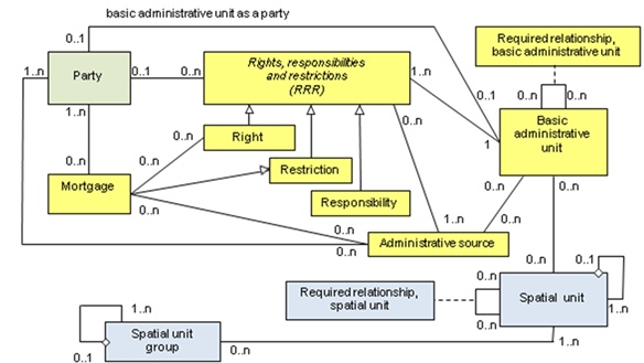
Figure 7 Administrative (yellow), spatial
(blue) and party (green) objects needed in the analysis of right-of-use
unit in LADM (version 2009-12-07)
The definition of a basic administrative unit is the following (LADM
document): administrative entity consisting of zero or more spatial
units corresponding to (one or more) unique and homogenous rights (e.g.
ownership right or land use right), responsibilities or restrictions
associated with the whole entity, as included in a land administration
system.
Definition of a party is the following (LADM document): persons, or
group of persons, or juridical persons that compose an identifiable
single (legal) entity, or a basic administrative unit.
4.2.1 Pre-analysis for a country profile of the right-of-use unit
The Finnish concept of basic property unit and parcel fits the LADM
concept of the basic administrative unit and spatial unit.
The right-of-use unit as an object fits the LADM basic administrative
unit. The right-of-use unit consists of one or several right-of-use
sub-units. Also the right-of-use sub-unit as an object fits the LADM
basic administrative unit.
A relationship is needed to show the hierarchy between the
right-of-use unit and its sub-units. The required relationship is
modelled for topology relationships. To model the hierarchy the
alternative could be to add a new association from the basic
administrative unit to itself (same kind of association as the spatial
unit has). This should be added to a country profile because LADM does
not currently support this.
The right-of-use unit has no geometry but its sub-units can be
located. The locations of the right-of-use sub-units fit the LADM
spatial unit. The location can be an area, a line or a point which fits
to the LADM concept.
Right holder (connected to the right-of-use sub-unit) fits the LADM
party. In a normal case a basic property unit holds the right; it plays
the role of a party (basic administrative unit as a party). In other
cases e.g. if the right holder is a certain municipality or a juridical
person (for example energy company), it is a LADM party itself.
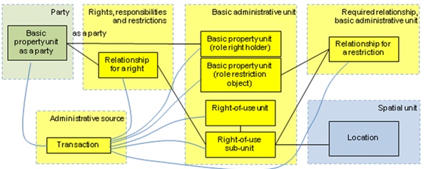
Figure 8 Result of pre-analysis of
right-of-use unit in country profile
Restriction object (connected to the right-of-use sub-unit) fits the
LADM required relationship (required relationship of basic
administrative unit). Polygon overlay is not used because it is not
possible to store the relationship information when using overlay. Also
some accuracy and legal aspects as well as data missing cases disable
the use of overlay.
5. EXPERIENCES
5.1 General experiences
Objects and terminology in INSPIRE and LADM models are not fully
comparable. Firstly, INSPIRE is a model for a data product specification
and LADM is a conceptual model. Secondly, INSPIRE UML model is a basis
of the automatic production of XML/GML schema (transfer file format).
This requires exact modelling. Thirdly, LADM is a generalized model with
a few objects for many purposes. Therefore, its scope is more for data
harmonisation than for data transfer.
Common code lists at least at the main level are required if
comparison of information between various countries is needed. LADM code
lists are presented as informal information and they will therefore be
included in the country profiles. Country profiles make it possible to
use precise terminology using legal aspects. The INSPIRE Cadastral
Parcels model does not include any essential code lists. The work to
reach consensus about common code lists is to be done in future.
5.2 Experiences of modelling in INSPIRE
Services expressed in INSPIRE legislation must be implemented using
this model. To define transformation rules from national databases to
INSPIRE services including all exceptional cases can be complicated,
although the INSPIRE model itself seems to be quite simple.
A lot of work was required to compile the terminology of objects
(e.g. parcel and basic property unit). Countries, in which the basic
unit for registration is a basic property unit (called e.g. real estate,
cadastral unit, real property unit) considered it necessary to include
this object in the model to fulfil the requirements of INSPIRE, as
others experienced this as tedious extra work. Finally, the object was
added to the model as defined in the document UN/ECE 2004 Guidelines on
Real Property Identifiers.
INSPIRE requires a unique identifier for a parcel. Such an identifier
is not given to parcels in
the Finnish system and no such identifier is required. The registered
object is a basic property unit which has the unique identifier. The
need in the on-line data information service to query individual parcel
information is obscure, if the basic property unit is the legal basic
object provided with an identifier at national level.
Some examples of how to produce values for area and temporal
attributes or problems to be solved:
- The area value for the basic property unit will be the total of
legal land area and legal water area.
- Values for wider areas are rounded and shown in hectares for
customers; INSPIRE requires area values in square meters.
- Area values for parcels are not registered. The calculated area
is not legal and it is not shown to customers.
- All temporal values are stored at day level. The legal data is
registered at day level. INSPIRE temporal value definitions also
include time.
If INSPIRE product does not fulfil national use cases, it means extra
work and could therefore cause more costs than benefits at least in the
short run.
5.3 Experiences of modelling in LADM
The result of LADM work will be an international standard. Currently
the work is in the draft stage of an international standard.
The data model has been changed a lot between the meetings owing to a
large number of comments. This shows something about the difficulty of
the modelling. It is still possible that the model needs a few, new
review cycles to provide a more stable result.
In LADM the academic freedom of modelling is limited because land
administration as a domain is related to legal aspects in such a large
extent. On the other hand, LADM is just a conceptual model and therefore
it can be seen in a positive way and accepted more easily than the
INSPIRE model.
The present stage of LADM work shows that a common model is possible.
Then again several unequal country profiles prove that a common model
has not yet been achieved.
5.4 Other experiences
To participate in international work so fully as to create concrete
models has been a unique and interesting experience. It has also brought
along new views to existing systems that has been very useful. To be
objective in the work is challenging because it is not easy to break
away from the national point of view. It is only natural since the
national system is the best known to everyone and especially if the
responsibility for implementation at natural level is predictable.
Practically it might be challenging to find motivation and especially
resources to adjust the national systems to international models or even
just to make the harmonised transfer files.
REFERENCES
- ISO/DIS 19152.1, Geographic information - Land Administration
Domain Model (LADM), version 2009-12-07.
- INSPIRE DS-D2.8.I.6, INSPIRE data specification on Cadastral
Parcels - Guidelines, v3.0, 2009-09-07.
- UN/ECE, 2004, United Nations/Economic Commission for Europe,
Guidelines on Real Property Units and Identifiers, United Nations,
New York and Geneva, 2004.
BIOGRAPHICAL NOTES
Tarja Myllymäki is a Master of Science (Surveying). She has
worked at the National Land
Survey of Finland since 1988 on several development projects (land
consolidation systems,
the JAKO cadastral system, the Real Estate Purchase Price registration
system, the Land
Information System and several Information Service projects). The last
few years she has also been involved in the INSPIRE thematic working
group Cadastral Parcels set up by the European Union and ISO Land
Administration Domain Model working group. She has been the Finnish
delegate to FIG Commission 3 since 1998.
Tarja Pykälä is a Master of Science (Surveying). She has
worked at the National Land Survey of Finland since 1981 on several
cadastral development projects, for example the JAKO cadastral system
and KTJkii cadastral system. She has also participated as an expert in
the Finnish INSPIRE and LADM working groups.
CONTACTS
Tarja Myllymäki
National Land Survey of Finland
P. O. Box 84
FIN-00521 Helsinki
FINLAND
Tel. +358 40 801 7696
Fax +358 206 31 5454
Email: tarja.myllymaki@nls.fi
Web site: www.nls.fi
Tarja Pykälä
National Land Survey of Finland
P. O. Box 84
FIN-00521 Helsinki
FINLAND
Tel. +358 40 801 7701
Fax + 358 206 31 5454
Email: tarja.pykala@nls.fi
Web site: www.nls.fi