Article of the Month -
July 2009
|
Facing the Global Agenda – Focus on Land Governance
Prof. Stig ENEMARK,
FIG President,
Aalborg University, Denmark

 This article in .pdf-format (13
pages and 351 KB)
This article in .pdf-format (13
pages and 351 KB)
1) This paper is based on the
keynote presentation that Prof. Stig Enemark, FIG President gave at the
FIG Working Week in Eilat, Israel, 3-8 May 2009.
Key words: surveyors, land governance, Millennium Development
Goals, spatially enabled government.
SUMMARY
“Do surveyors have a role to play in the global agenda?” - from a FIG
point of view the answer to this question is clearly a “Yes”! Simply, no
development will take place without having a spatial dimension, and no
development will happen without the footprint of surveyors – the land
professionals.
There is a big swing that could be named “From Measurement to
Management”. This paper presents the changing role of the surveyors and
their commitment to the global agenda in terms of sound Land Governance
in support of the Millennium Development Goals.
1. THE GLOBAL AGENDA
The eight Millennium Development Goals (MDGs) form a blueprint agreed
to by all the world’s countries and the world’s leading development
institutions. The first seven goals are mutually reinforcing and are
directed at reducing poverty in all its forms. The last goal - global
partnership for development - is about the means to achieve the first
seven. These goals are now placed at the heart of the global agenda. To
track the progress in achieving the MDGs a framework of targets and
indicators is developed. This framework includes 18 targets and 48
indicators enabling the ongoing monitoring of the progress that is
reported on annually (UN, 2000).
“Do surveyors have a role to play in the global agenda?” -
from a FIG point of view the answer to this question is clearly a “Yes”!
The surveyors play a key role in supporting an efficient land market and
also effective land-use management. These functions underpin development
and innovation and form a kind of “backbone” in society that supports
social justice, economic growth, and environmental sustainability.
Simply, no development will take place without having a spatial
dimension, and no development will happen without the footprint of
surveyors – the land professionals.
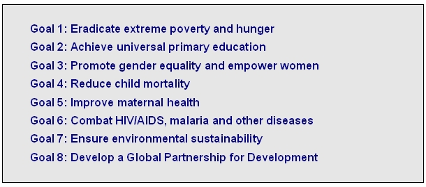
Figure 1. The Eight Millennium Development Goals
The MDGs represent a wider concept or a vision for the future, where
the contribution of the global surveying community is central and vital.
This relates to the areas of providing the relevant geographic
information in terms of mapping and databases of the built and natural
environment, and also providing secure tenure systems, systems for land
valuation, land use management and land development. These aspects are
all key components within the MDGs.
In a global perspective the areas of surveying and land
administration are basically about people, politics, and
places. It is about people in terms human rights,
engagement and dignity; it is about politics in terms of land
policies and good government; and it is about places in terms of
shelter, land and natural resources.
Contributing to the Global agenda is about “flying high”. But the
idea is also to better understand the very key role that the surveying
profession play in underpinning sustainable development at national and
local level. This is about the daily work of the surveyors in meeting
the needs of the clients – it is about “keeping the feet on the ground”.
In facing the global agenda the role of FIG – the global surveying
community - is threefold: (i) to explain the role of the surveying
profession and the surveying disciplines in terms of their contribution
to the MDGs. Such statements should also make the importance of the
surveying profession disciplines better understood in a wider political
context; (ii) to develop and disseminate knowledge, policies and methods
towards achieving and implementing the MDGs - a number of FIG
publications have already made significant contributions in this regard;
and (iii) to work closely with the UN agencies and the World Bank in
contributing to the implementation of the MDGs.
An outcome of these efforts relates to cooperation with UN-Habitat in
developing a model for providing secure social tenure for the poorest
(Augustinus et.al. 2006). Another outcome is the recent joint FIG/World
Bank conference held in March 2009 focusing on “Land Governance in
Support of the MDGs – Facing the New Challenges”, see
http://www.fig.net/news/news_2009/fig_wb_march_2009.htm.
2. FROM MEASUREMENT TO MANAGEMENT
“Is the role of the surveyors changing?” – in a global perspective
the answer will be “Yes”! There is a big swing that could be entitled
“From Measurement to Management”. This does not imply that measurement
is no longer a relevant discipline to surveying. The change is mainly in
response to technology development. Collection of data is now easier,
while assessment, interpretation and management of data still require
highly skilled professionals. The role is changing into managing the
measurements. There is wisdom in the saying that “All good coordination
begins with good coordinates” and the surveyors are the key providers.
In the more technical and natural science area of surveying this move
can be illustrated by the evolution from the concept of Geodetic Datums
to Positioning Infrastructures. A geodetic datum is a (multi level)
geodetic reference framework describing positions in three dimensions.
It supports the traditional functions of surveying and mapping and
underpins all of what we now call geo-spatial information. The concept
of a Positioning Infrastructure is based on Global Navigation Satellite
Systems (GNSS) such as GPS and extends to the ground infrastructure used
to improve the accuracy and reliability of GNSS positioning for users.
It widens the functions to enable the monitoring of global processes
such as those associated with climate change and disaster risk
management and also real time positioning for e.g. agricultural farming
purposes (Higgins, 2009).
The concept of a modern Positioning Infrastructure (combining
satellites and reference stations on the ground) still supports the
activities traditionally associated with a geodetic datum but extends
toward much broader roles on the global scale. It can be argued that
GNSS could be considered one of the only true global infrastructures in
that the base level of quality and accessibility is constant across the
globe. Such a Positioning Infrastructure moves the focus from
measurement of framework points to management of the data received from
the positioning system.
The change from measurement to management also means that surveyors
increasingly contribute to building sustainable societies as experts in
managing land and properties. As mentioned above, the surveyors play a
key role in supporting an efficient land market and also effective
land-use management that underpin development and innovation for social
justice, economic growth, and environmental sustainability.
3. LAND GOVERNANCE
Arguably sound land governance is the key to achieve sustainable
development and to support the global agenda set by adoption of the
Millennium Development Goals (MDGs).
Land governance is about the policies, processes and institutions by
which land, property and natural resources are managed. This includes
decisions on access to land, land rights, land use, and land
development. Land governance is basically about determining and
implementing sustainable land policies. Such a global perspective for
Land Governance or Land Management is shown in figure 2.
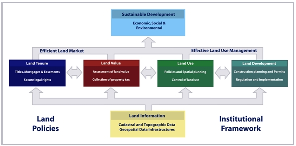
Figure 2. A Global Land Management Perspective (Enemark, 2004).
Land governance and management covers all activities associated with
the management of land and natural resources that are required to fulfil
political and social objectives and achieve sustainable development.
Land management requires inter-disciplinary skills that include
technical, natural, and social sciences. The operational component of
the land management concept is the range of land administration
functions that include the areas of land tenure (securing and
transferring rights in land and natural resources); land value
(valuation and taxation of land and properties); land use (planning and
control of the use of land and natural resources); and land development
(implementing utilities, infrastructure, construction planning, and
schemes for renewal and change of existing land use).
Land administration systems (LAS) are the basis for conceptualizing
rights, restrictions and responsibilities. Property rights are normally
concerned with ownership and tenure whereas restrictions usually control
use and activities on land. Responsibilities relate more to a social,
ethical commitment or attitude to environmental sustainability and good
husbandry. In more generic terms, land administration is about managing
the relations between people, policies and places in support of
sustainability and the global agenda set by the MDGs.
3.1 Property Rights
In the Western cultures it would be hard to imagine a society without
having property rights as a basic driver for development and economic
growth. Property is not only an economic asset. Secure property rights
provide a sense of identity and belonging that goes far beyond and
underpins the values of democracy and human freedom. Historically,
however, land rights evolved to give incentives for maintaining soil
fertility, making land-related investments, and managing natural
resources sustainably. Therefore, property rights are normally managed
well in modern economies. The main rights are ownership and long term
leasehold. These rights are typically managed through the cadastral/land
registration systems developed over centuries. Other rights such as
easements and mortgage are often included in the registration systems.
The formalized western land registration systems are basically
concerned with identification of legal rights in support of an efficient
land market, while the systems do not adequately address the more
informal and indigenous rights to land that is found especially in
developing countries where tenures are predominantly social rather than
legal. Therefore, traditional cadastral systems can not adequately
supply security of tenure to the vast majority of the low income groups
and/or deal quickly enough with the scale of urban problems. A new and
innovative approach is found in the continuum of land rights (including
perceived tenure, customary, occupancy, adverse possession, group
tenure, leases, freehold) where the range of possible forms of tenure is
considered as a continuum from informal towards more formal land rights
and where each step in the process of securing the tenure can be
formalised (UN-Habitat, 2008).
3.2 Property Restrictions
Land-use planning and restrictions are becoming increasingly
important as a means to ensure effective management of land-use, provide
infrastructure and services, protect and improve the urban and rural
environment, prevent pollution, and pursue sustainable development.
Planning and regulation of land activities cross-cut tenures and the
land rights they support. How these intersect is best explained by
describing two conflicting points of view – the free market approach and
the central planning approach.
The free market approach argues that land owners should be obligated
to no one and should have complete domain over their land. In this
extreme position, the government opportunity to take land (eminent
domain), or restrict its use (by planning systems), or even regulate how
it is used (building controls) should be non-existent or highly limited.
The central planning approach argues that the role of a democratic
government includes planning and regulating land systematically for
public good purposes. Regulated planning is theoretically separated from
taking private land with compensation and using it for public purposes.
In these jurisdictions the historical assumption that a land owner could
do anything than was not expressly forbidden by planning regulations
changed into the different principle that land owners could do only what
was expressly allowed, everything else being forbidden.
The tension between these two points of view is especially felt by
nations seeking economic security. The question however is how to
balance owners’ rights with the necessity and capacity of the government
to regulate land use and development for the best of the society. The
answer to this is found in a country’s land policy which should set a
reasonable balance between the ability of land owners to manage their
land and the ability of the government to provide services and regulate
growth for sustainable development. This balance is a basis for
achieving sustainability and attaining the MDGs.
Informal development may occur in various forms such as squatting
where vacant state-owned or private land is occupied and used illegally
for housing or any construction works without having formal permission
from the planning or building authorities. Such illegal development
could be significantly reduced through government interventions
supported by the citizens. Underpinning this intervention is the concept
of integrated land-use management as a fundamental means to support
sustainable development, and at the same time, prevent and legalise
informal development (Enemark and McLaren, 2008).
3.3 Property Responsibilities
Property responsibilities are culturally based and relate to a more
social, ethical commitment or attitude to environmental sustainability
and good husbandry. Individuals and other actors are supposed to treat
land and property in a way that conform to cultural traditions and ways
of good ethical behaviour. This relates to what is accepted both legally
and socially. Therefore, the systems for managing the use of land vary
throughout the world according to historical development and cultural
traditions. More generally, the human kind to land relationship is to
some extent determined by the cultural and administrative development of
the country or jurisdiction.
Social responsibilities of land owners have a long heritage in
Europe. In Germany, for example, the Constitution is insisting on the
land owner’s social role. In general, Europe is taking a comprehensive
and holistic approach to land management by building integrated
information and administration systems. Other regions in the world such
as Australia creates separate commodities out of land, using the concept
of “unbundling land rights”, and is then adapting the land
administration systems to accommodate this trading of rights without any
national approach.
4. THE LAND MANAGEMENT PARADIGM
Land management underpins distribution and management of a key asset
of any society namely its land. For western democracies, with their
highly geared economies, land management is a key activity of both
government and the private sector. Land management, and especially the
central land administration component, aim to deliver efficient land
markets and effective management of the use of land in support of
economic, social, and environmental sustainability.
The land management paradigm as illustration in figure 3 below allows
everyone to understand the role of the land administration functions
(land tenure, land value, land use, and land development) and how land
administration institutions relate to the historical circumstances of a
country and its policy decisions. Importantly, the paradigm provides a
framework to facilitate the processes of integrating new needs into
traditionally organised systems without disturbing the fundamental
security these systems provide.
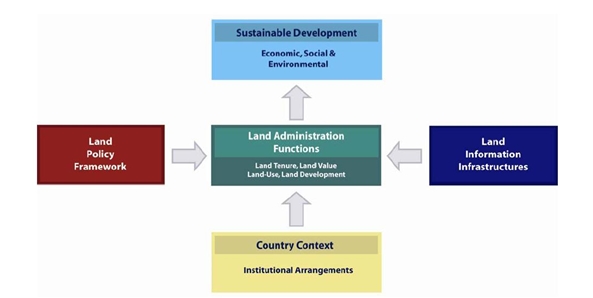
Figure 3. The land management paradigm (Enemark, 2004)
Sound land management requires operational processes to implement
land policies in comprehensive and sustainable ways. Many countries,
however, tend to separate land tenure rights from land use
opportunities, undermining their capacity to link planning and land use
controls with land values and the operation of the land market. These
problems are often compounded by poor administrative and management
procedures that fail to deliver required services. Investment in new
technology will only go a small way towards solving a much deeper
problem: the failure to treat land and its resources as a coherent
whole.
4.1 Hierarchy of land issues
The response to change pressures in any particular jurisdiction will
depend on how local leaders understand the vision. While the larger
theoretical framework described above is futuristic for many countries,
they must still design their land administration systems around the land
management paradigm. A simple entry point showing how to do this uses a
hierarchy of land issues in figure 4 showing how the concepts involved
in the paradigm fit together in a hierarchical manner ranging from land
policies to the land parcel.
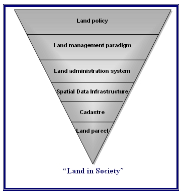
Figure 4. Hierarchy of land issues
Land policy determines values, objectives and the legal
regulatory framework for management of a society’s major asset, its
land.
The land management paradigm applies to LAS design to drive an
holistic approach to the LAS, and forces its processes to contribute to
sustainable development. The paradigm allows LAS to assist land
management generally. Land management activities include the core land
administration functions: land tenure, value, use and development, and
encompass all activities associated with the management of land and
natural resources that are required to achieve sustainable development.
The land administration system provides the infrastructure for
implementation of land policies and land management strategies, and
underpins the operation of efficient land markets and effective land use
management. The cadastre is at the core of any LAS.
The spatial data infrastructure provides access to and
interoperability of the cadastral information and other land
information.
The cadastre provides the spatial integrity and unique
identification of every land parcel usually through a cadastral map
updated by cadastral surveys. The parcel identification provides the
link for securing rights in land, controlling the use of land and
connecting the ways people use their land with their understanding of
land.
The land parcel is the foundation of the hierarchy because it
reflects the way people use land in their daily lives. It is the key
object for identification of land rights and administration of
restrictions and responsibilities in the use of land. The land parcel
links the system with the people.
The hierarchy illustrates the complexity of organizing policies,
institutions, processes, and information for dealing with land in
society. But it also illustrates an orderly approach represented by the
six levels. This conceptual understanding provides the overall guidance
for building LAS in any society, no matter the level of development. The
hierarchy also provides guidance for adjustment or reengineering of
existing LAS. This process of adjustment should be based on constant
monitoring of the results of the land administration and land management
activities. The land policies may then be revised and adapted to meet
the changing needs in society. The change of land policies will require
adjustment of the LAS processes and practices that, in turn, will affect
the way land parcels are held, assessed, used, or developed.
5. SPATIALLY ENABLED GOVERNMENT
Place matters! Everything happens somewhere. If we can understand
more about the nature of “place” where things happen, and the impact on
the people and assets on that location, we can plan better, manage risk
better, and use our resources better (Communities and Local Government,
2008). Spatially enabled government is achieved when governments use
place as the key means of organising their activities in addition to
information, and when location and spatial information are available to
citizens and businesses to encourage creativity.
New distribution concepts such as Google Earth provide user friendly
information in a very accessible way. We should consider the option
where spatial data from such concepts are merged with built and natural
environment data. This unleashes the power of both technologies in
relation to emergency response, taxation assessment, environmental
monitoring and conservation, economic planning and assessment, social
services planning, infrastructure planning, etc. This also include
designing and implementing a suitable service oriented IT-architecture
for organising spatial information that can improve the communication
between administrative systems and also establish more reliable data
based on the use of the original data instead of copies.
Spatial enablement offers opportunities for visualisation,
scalability, and user functionalities. This is related to institutional
challenges with a range of stakeholder interests. This includes
Ministries/Departments such as: Justice; Taxation; Planning;
Environment; Transport; Agriculture; Housing; Regional and Local
Authorities; Utilities; and civil society interests such as businesses
and citizens. Creating awareness of the benefits of developing a shared
platform for Integrated Land Information Management takes time. The
Mapping/Cadastral Agencies have a key role to play in this regard. The
technical core of Spatially Enabling Government is the spatially enabled
cadastre.
5.1 Significance of the Cadastre
The land management paradigm makes a national cadastre the engine of
the entire LAS, underpinning the country’s capacity to deliver
sustainable development. The role of the cadastre as the engine of LAS
is neutral in terms of the historical development of any national
system, though systems based on the German and Torrens approaches, are
much more easily focused on land management than systems based on the
French/Latin approach. The cadastre as an engine of LAS is shown
diagrammatically in figure 5.
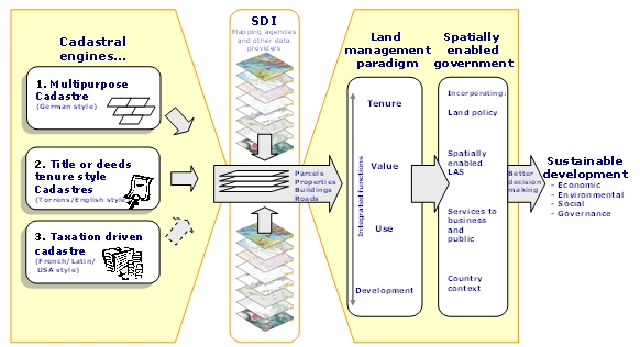
Figure 5. Significance of the Cadastre (Williamson, Enemark,
Wallace, Rajabifard, 2009)
The diagram highlights the usefulness of the large scale cadastral
map as a tool by exposing its power as the representation of the human
scale of land use and how people are connected to their land. The
digital cadastral representation of the human scale of the built
environment, and the cognitive understanding of land use patterns in
peoples’ farms, businesses, homes, and other developments, then form the
core information sets that enable a country to build an overall
administrative framework to deliver sustainable development.
The diagram demonstrates that the cadastral information layer cannot
be replaced by a different spatial information layer derived from
geographic information systems (GIS). The unique cadastral capacity is
to identify a parcel of land both on the ground and in the system in
terms that all stakeholders can relate to, typically an address plus a
systematically generated identifier (given addresses are often
duplicated or are otherwise imprecise). The core cadastral information
of parcels, properties and buildings, and in many cases legal roads,
thus becomes the core of SDI information, feeding into utility
infrastructure, hydrological, vegetation, topographical, images, and
dozens of other datasets.
5.2 Good governance
Governance refers to the manner in which power is exercised by
governments in managing a country’s social, economic, and spatial
recourses. It simply means: the process of decision-making and the
process by which decisions are implemented. This indicates that
government is just one of the actors in governance. The concept of
governance includes formal as well as informal actors involved in
decision-making and implementation of decisions made, and the formal and
informal structures that have been set in place to arrive at and
implement the decision. Good governance is a qualitative term or an
ideal which may be difficult to achieve. The term includes a number of
characteristics: (adapted from FAO, 2007):
- Sustainable and locally responsive: It balances the
economic, social, and environmental needs of present and future
generations, and locates its service provision at the closest level
to citizens.
- Legitimate and equitable: It has been endorsed by society
through democratic processes and deals fairly and impartially with
individuals and groups providing non-discriminatory access to
services.
- Efficient, effective and competent: It formulates policy
and implements it efficiently by delivering services of high quality
- Transparent, accountable and predictable: It is open and
demonstrates stewardship by responding to questioning and providing
decisions in accordance with rules and regulations.
- Participatory and providing security and stability: It
enables citizens to participate in government and provides security
of livelihoods, freedom from crime and intolerance.
- Dedicated to integrity: Officials perform their duties
without bribe and give independent advice and judgements, and
respects confidentiality. There is a clear separation between
private interests of officials and politicians and the affairs of
government.
Once the adjective “good” is added, a normative debate begins. In
short: sustainable development is not attainable without sound land
administration or, more broadly, sound land management.
6. FACING THE NEW CHALLENGES
The key challenges of the new millennium are clearly listed already.
They relate to climate change; food shortage; energy scarcity; urban
growth; environmental degradation; and natural disasters. These issues
all relate to governance and management of land. Land governance is a
cross cutting activity that will confront all traditional
“silo-organised” land administration systems.
Land governance and management is going to be a core area for the
surveyors – the land professionals. This area requires high level
geodesy to create the models that can predict future changes; modern
surveying and mapping tools that can control implementation of new
physical infrastructure and also provide the basis for the building of
National spatial data infrastructures; and finally sustainable land
administration systems that can manage the core functions of land
tenure, land value, land use, and land development.
FIG (the International Federation of Surveyors) intend to play a
strong role in building the capacity to design, build and manage
national surveying and land administration systems that facilitates
sustainable Land Governance in support of the MDGs. In short, FIG is
aiming at “Building the capacity for taking the land policy agenda
forward”.
7. FINAL REMARKS
The MDGs represent a wider concept or a vision for the future, where
the contribution of the land professionals is central and vital. FIG,
being a global NGO representing the surveying community/land
professionals in more than 100 countries throughout the world, is
strongly committed to the global agenda as presented in the MDGs.
The surveyors – nationally and globally – will have a key role as
providers of the relevant spatial information and also as builders of
efficient land tenure systems and effective measures for urban and rural
land use management. The role of FIG is about “Building the Capacity” in
this area.
Issues such as tenure security, pro-poor land management, and good
governance in land administration are all key issues to be advocated in
the process of contributing to the global agenda. Measures such as
capacity assessment, institutional development and human resource
development are all key tools in this regard. More generally, the work
of the land professionals within land management forms a kind of
“backbone” in society that supports social justice, economic growth, and
environmental sustainability. These aspects are all key components in
facing the global agenda.
REFERENCES
- Augustinus, C., Lemmen, C.H.J. and van Oosterom, P.J.M. (2006)
Social tenure domain model requirements from the perspective of pro
- poor land management. Proceeding of the 5th FIG regional
conference, 8-11 March 2006, Accra, Ghana.
http://www.fig.net/pub/accra/papers/ps03/ps03_01_augustinus.pdf
- Communities and Local Government (2008): Place matters: the
Location Strategy for the United Kingdom.
http://www.communities.gov.uk/publications/communities/locationstrategy
- Enemark, S. (2004): Building Land Information Policies.
Proceedings of Special Forum on Building Land Information Policies
in the Americas. Aguascalientes, Mexico, 26-27 October 2004.
http://www.fig.net/pub/mexico/papers_eng/ts2_enemark_eng.pdf
- Enemark, S. and McLaren, R. (2008): Preventing Informal
Development – through Means of Sustainable Land Use Control.
Proceedings of FIG Working Week, Stockholm, 14-19 June 2008.
http://www.fig.net/pub/fig2008/papers/ts08a/ts08a_01_enemark_mclaren_2734.pdf
- Higgins, M. (2009): Positioning Infrastructures for sustainable
Land Governance. Proceedings of FIG/WB Conference on Land Governance
in Support of the MDGs, Washington, 9-10 March 2009.
http://www.fig.net/pub/fig_wb_2009/papers/sys/sys_1_higgins.pdf
- UN-Habitat (2008): Secure Land Rights for all. UN Habitat,
Global Land Tools Network.
http://www.gltn.net/en/e-library/land-rights-and-records/secure-land-rights-for-all/details.html
- Williamson, Enemark, Wallace, Rajabifard (2009): Land
Administration Systems for Sustainable Development. ESRI Press. In
press.
BIOGRAPHICAL NOTES
Stig Enemark is President of the International Federation of
Surveyors, FIG 2007-2010. He is Professor in Land Management and Problem
Based Learning at Aalborg University, Denmark, where he was Head of
School of Surveying and Planning 1991-2005. He was President of the
Danish Association of Chartered Surveyors (DdL) 2002- 2006 and he is an
Honorary Member of DdL. He is a well known international expert in the
areas of land administration systems, land management and spatial
planning, and related educational and capacity building issues. He has
published widely in these areas and undertaken consultancies for the
World Bank and the European Union especially in Eastern Europe, Sub
Saharan Africa.
CONTACTS
Prof. Stig Enemark
FIG President
Department of Development and Planning,
Aalborg University, 11 Fibigerstrede
9220 Aalborg, DENMARK
Email: enemark@land.aau.dk
Website:
www.land.aau.dk/~enemark
 |


