Article of the
Month - June 2021
|
Identifying which human aspects play a crucial
role in land consolidation processes
Walter Timo de Vries, Germany
 |
| Walter Timo de Vries |
This article in .pdf-format (15 pages)
The article examines the optimal conditions required for the
implementation of the SDB method and tests them in the area of the
middle Adriatic sea basin (Murter channel).
SUMMARY
This paper introduces and analyses how which
human aspects play a role in land consolidation processes. The analysis
is based on a selected set of recent research results on land
consolidation practices, on the basis of which - in an exploratory way
- a set of fundamental human aspects are derived, which together may
constitute a (human geodetic) framework. These aspects include: human
identity, human values, human sentiments, human recognition, human
dignity, human variation, human relations, and human choices. All of
these aspects are interrelated, but understanding, measuring and
interpreting each of these is relevant for specific parts of land
consolidation (and other division, allocation and re-distribution)
processes and collecting data for each requires different techniques and
methods. Further conceptual and empirical development is recommended to
understand better how these aspect influence the processes,
institutional acceptance and the outcomes of land consolidation.
1. INTRODUCTION
Geodetic engineers consider land consolidation a key task of geodetic
engineers. Land consolidation is a kind of land intervention, which
requires both a thorough understand of how to measure and demarcate
land, and an understanding of how to allocate or exchange ownership of
land. The former necessitates both specific mathematical and information
technical skills, which are typical for an engineer and prototypical for
a geodetic engineer. The latter requires a thorough understanding of
legal and organisational issues related to land rights, land ownership
and procedural aspects.
The conventional association of the scope and utilization of land
consolidation is with agricultural economics and rural development. FAO
(2003) refer to land consolidation as a tool which can assist farmers to
amalgamate their fragmented parcels. For example, a farmer who owns one
hectare divided into five parcels may benefit from a consolidation
scheme which results in a single parcel. In many eastern European (FAO,
2004, Hartvigsen, 2014) land consolidation programs tend to have
primarily such an economic and/or and rural development focus (Bullard,
2007). More recently land consolidation is associated specifically to a
societal benefit or public value, such as food security (Bennett et al.,
2015, Ntihinyurwa et al., 2019) or environmental protection (Abubakari
et al., 2016, Louwsma et al., 2014). Not the micro-economic agricultural
production values count in these cases, but the public values at a
larger – often national or regional - scale. The optimal output of a
land consolidation process then needs to be evaluated in terms of this
societal benefit, rather than a pure economic benefit.
Method-wise, Louwsma and Lemmen (2015) introduce land consolidation
as an instrument to counteract land fragmentation and the associated
negative impact on the productivity and costs of farming. The most
common interpretation of land fragmentation relates to physical aspects
of fragmentation, i.e. holdings with a large number of small parcels
scattered over a considerable area (Ntihinyurwa et al., 2019). Savoiu et
al. (2015) indicate that different types of land consolidation exist
which each require different methodologies of implementation and
different indicators of optimization. Vitikainen (2004) specifies such
indicators of land consolidation: defragmentation of parcel size and
location (improvement of agricultural and/or forest land division,
re-allotment of leasehold areas, enlargement of farm size),
reconstruction of urban areas (land use planning in village areas,
readjustment of building land), creation of accessibility to roads and
utilities (improvement of road network, drainage network), environmental
protection and planning (implementation of environment and nature
conservation areas), spatial and regional development (promotion of
regional development). Demetriou et al. (2013) further specify
procedures and decision support systems to quantify the resultant
optimization parcel sizes.
In the world of praxis land consolidation often relies on having
inter-personal, social and communication skills. These skills are often
only taught and learned after graduating from geodetic or surveying
engineering study programs. Nonetheless these skills and knowledge are
apparently considered crucial for geodetic engineers. After all, the
original meaning of geodesy is shaped by two Greek words, γεωδαισία or
geodaisia, literally meaning the "division of the Earth". So, the
original meaning of geodesy deals with activity of dividing rather than
the static status quo of division, although by most geodesy is primarily
associated with measurements of the earth’s shape, the boundaries
between parcels and zones and the gravitational field. de Vries (2017)
argues that constituting, defining and framing a new scientific field
called ‘human geodesy’ is necessary and relevant given the
transdisciplinary and human nature of dividing the earth. Hence there is
a strong need to understand and conceptualise what these skills mean in
the geodetic field. This article describes and classifies what these
human aspects are, and how and why they are relevant parts of the
geodetic profession. To underline this relevance it derives a
theoretical framework for what will be called human geodesy.
This paper first provides short synopses of three research
experiences. These experiences in land consolidation are described at
different scales. Each of these specifically focused on the practices of
land consolidation rather than the regulatory and technical aspects of
land consolidation. The first research deals with land consolidation
practices in different parts of Bavaria, Germany. The second was a
comparative study between Bavaria and the Republic of Macedonia. The
third concerned a European-wide comparison on land consolidation
practices. The following section discusses, highlights and classifies a
number of aspects which can be considered related to people, their views
and their behaviour. From these a a set of principles are derived which
will be referred to as human geodetic operational principles. The
concluding section provide a general synopsis and a number of
recommendations for further research.
2. RESEARCH EXPERIENCES IN LAND CONSOLIDATION FROM A GEODETIC
PROFESSIONAL PERSPECTIVE
2.1 Land consolidation in Bavaria
The study of Guggemos (2018) aims at comparing the theory (i.e. the
prescribed act and regulations) with the practical implementation of
land consolidation in Bavaria. Guggemos (2018) compares different
aspects of the land consolidation practices in different parts of
Bavaria, Germany. The institutional arrangement in Bavaria is that there
is a land consolidation act which applies for the entire Bavaria, but in
each region the rural development agencies can make their own decisions
on how and where to conduct a land consolidation project. The study
reveals that although there are only minor deviations between the law
and the practice, not because of a major infringement or deviation from
the law, but as a way to align discretionary space which the law
provides to the existing situation on the ground. It was found that the
biggest differences between theory and practice were connected to the
communication with stakeholders and the public. In Bavaria, as part of
the implementation of a land consolidation project, significantly more
is involved and communicated than is formally required by law - ranging
from the early involvement of the authorities to additional meetings,
working groups, corridor workshops and on-site inspections, to a two-day
meeting organized by the school of village and rural development. Often
the communication is most successful if local dialects are used.
The increased attention for the human aspect of communication
complements a major shift in focus land consolidation projects in
Bavaria. Projects which solely focus on agricultural improvement are
steadily declining, whilst improving nature, environment and flood
protection is increasingly coming to the forefront. In these domains
both the number and variety of insights and priorities of stakeholders
is much larger than the pure agricultural economic interests. Hence, the
ability to speak at different registers and understand the epistemic
language of different domains is crucial.
In addition, priority is currently being given to speedy procedures
of land consolidation. Given that historically land consolidation
projects could take more than 20 to 30 years to complete, currently the
simplified land consolidation procedure and/or the voluntary land
exchanges are preferred over the large-scale land consolidation
projects. In such smaller projects it is easier to communicate as a
group of stakeholders, as one can know each other and each other’s
priorities quite rapidly.
2.2 Comparative study Bavaria vs Republic of Macedonia
In order to evaluate to which extent and how context plays in
conducting land consolidation projects in 2018 a study was made
comparing land consolidation practices in Bavaria with those in Republic
Macedonia (de Vries et al., 2018). The study aims at comparing two cases
with significantly different histories and policy settings: Land
consolidation in the free State of Bavaria in Germany, where land
consolidation has been a practice for over 100 years, even though its
usage is gradually declining; and, land consolidation in Republic
Macedonia, where the land consolidation law has been recently
re-designed, and where land consolidation is a relatively new tool in
the land management practice. The comparison entails institutional and
legal frameworks, practices in relation to start, execution and
completion of land consolidation projects. Data were compared through
extensive document analysis, expert interviews and site visits of land
consolidation projects in both Bavaria and Republic Macedonia.
The comparison reveals that many operational practices of land
consolidation are highly dependent on local historical decisions, which
cannot be easily adapted. Land consolidation legislation has regularly
changed in both Bavaria and Republic Macedonia, even though the current
Bavarian legislation seems relatively stable. Still, adaption has
taken place, for example to accommodate other interests than
agricultural ones, including rural development objectives at large and
environmental concerns in particular. Also, the organisational
structures through which land consolidation is to be carried out has
changed over time. Where originally the rural development agency took a
leading role, currently much more authority has been transferred to the
local land consolidation committees. The main reason and justification
to adopt these gradual changes was to handle different kinds of
uncertainties: process uncertainty arising from possible resistance of
stakeholders who might obstruct the process by prioritizing individual
benefits over common benefits.
Although in both Bavaria and Republic Macedonia land surveyors and
geodesists (potentially) play an active role in land consolidation
processes, their role and institutional embedding is completely
different. In Bayern land surveyors are employed by the agency for rural
development and are tasked to help co-design the land re-allocation plan
and stake out new boundaries. It is even so that land surveying and/or
geodesy education are pre-requirements for a position at the rural
development agency. In Republic Macedonia the Ministry for Agriculture,
Forestry and Water Economy, department for land consolidation, does not
employ land surveyors or geodesist. Instead they rely on agricultural
specialists for most of the land consolidation tasks and decisions. In
general the geodesists are employed by private firms, who carry out
certain tasks which are subcontracted by the Ministry. One of the
anticipated tasks for land surveying firms includes the conduct of
pre-land consolidation feasibility studies, a tasks for which they are
not principally educated. As a result, they need to be upgraded by the
MAINLAND project in order to be able to conduct such a task.
Coercing participants to join and/or participate land consolidation
projects to achieve public objectives is possible in Bavaria, yet highly
contested in Republic Macedonia. There is still a significant difference
between Bavaria and Republic Macedonia in the manner in which coercion,
enforcement and sanctioning can take place in case of non-participation
or non-compliance to land consolidation projects and re-allotment plans.
A vital role exists in Bavaria for the committee of stakeholders who
ultimately decide, whereas in Republic Macedonia the final decision for
start of land consolidation project is rooted in the Ministry. This
might hamper the sense of ownership related to the decision, but at the
same time this may also reflect a fundamental difference in how to
ensure compliance.
The degree to which the rural development agencies in Bavaria are
accepted and respected by local stakeholders is high. This is however
not a given and a characteristic which is automatically achieved simply
by the legislation itself. Many agencies have active press and/or
marketing officers and staff member whose primary task it is to explain
the role and functions of the agency. The MAINLAND project in Republic
Macedonia is also taking this extension and awareness raising function
seriously in order to raise legitimacy. Hence, in both Bavaria and
Macedonia legitimacy is a crucial issue. Both countries justify this by
stating that land consolidation may often be contested by local farmers.
It is therefore vital to speak at eyesight and frequently explain and
discuss the pros and cons of land consolidation with local stakeholders
in order to ensure legitimacy.
2.3 European-wide study on land consolidation practices
The 2019 study of de Vries et al. (2019) compares land consolidation
practices for 20 countries. Similar to the studies of Guggemos (2018)
and de Vries et al. (2018) the main focus of the study was on
revealing the practice of land consolidation. In this study the practice
is derived from an analysis of the experiences of senior professional
land consolidators, captured through so-called narrative vignettes, i.e.
short personal stories of experiences, opinions and perceptions. The
study concludes that despite regional differences in preferences,
attitudes and opinions about whether land consolidation is an
appropriate instrument, there seems to be some consensus that land
consolidation projects should currently be highly pragmatically
oriented, whereby one has to be very sensitive to the needs and
characteristics of local contexts and stakes, and whereby one needs to
be very clear on both short-term and long-term wins.
A crucial conclusion form a human perspective in this study is that
becoming a practical land consolidator requires a steep learning curve,
which is heavily reliant on personal and long-term experience.
Knowledge, skills and experience go hand-in-hand for land consolidators.
Land consolidation requires specific human skills: a high ability to
compromise, the ability to communicate with responsible persons, a deep
interest in all people living and working in the area, the ability to
deal with people, being able to motivate and inspire stakeholders,
having a personality which is never discouraged from setbacks and which
is open for new challenges and have a personal vision.
3. CLASSIFYING THE HUMAN ASPECTS
All three research experiences indicate that human and social aspects
are crucial in land consolidation and that professional land
consolidators need to be able to understand and work with these.
Hence, it is important to understand which human aspects play a role,
and how one can detect, capture and analyse these on the one hand, and
apply the insights as geodetic engineers on the other hand. The
different human aspects are discussed hereunder.
3.1 Human identity
The experience form land consolidation projects indicate that
changing relations to land are often taken personally. There is a strong
sense of land tenants that the land relates to a sense of history,
heritage, home, and family. One could capture this strongly felt
relation as human identity. People identify with the place where they
grew up, where they made their first experiences and relations, and
where they heard the stories from their past from their elders and
ancestors. Human identity is very location specific, and as a
result it plays a strong role in the division of land and how people
would allocate land if they were amongst their peers in identity.
Golubović (2011) describes human identity as ‘where one (a person or a
group) belongs, and what is expressed as “self-image” or/and
“common-image”, what integrate them inside self or a group existence,
and what differentiate them vis-à-vis “others”’. The concept itself has
various dimensions, yet it is not a neutral concept. It varies along
with people and with space, and as a consequence, it plays a role in the
division of space. It also has a close connection to cultural heritage
to both social and physical (landscape) preferences (Krupowicz et al.,
2019).
Human identity is the human geodetic equivalent of gravity in
physical geodesy. Similar to gravity is it omnipresent and it softens
gradually with distance. At the same time there are also micro
differences which can be very influential for local outcomes. Yet, how
does one capture human identity as a geodesist? It has to be done using
methods which are directly related to how individuals, who have a stake
in land division matters, identify with the land and also take decisions
in the process of individuation, i.e. the degree to which individuals or
groups of individuals can be differentiated from each other. Here
one can make use of interactive methods of data collection, i.e. through
interviews, focus groups, interactive ranking methods. In addition one
can make use of observational methods and seek patterns in how
individuals speak, behave, react, use metaphors and symbols and refer
consistently to places of value and significance.
3.2 Human values
Closely related to identity but different in both data collection and
analysis is the aspect of human values, or perhaps better the collection
of normative values, beliefs and views. In land consolidation processes
it became obvious that stakeholders do not just have different views and
opinions on how the processes of re-distribution should be carried out
and which preferences for certain outcomes existed, but that these views
and opinions were rooted in more or less coherent belief systems, i.e.
normative frameworks of what is considered good or bad, right or wrong.
In these normative frameworks one can differentiate two types:
Professional (epistemological) views and beliefs and personal views and
beliefs. Professional epistemological aspects and values reflect the
commonly accepted professional views and experiences, connections and
professional networks, educational backgrounds and professional
ambitions, whereas personal views and beliefs are much more connected to
life experience epistemologies and values. Personal values reflect
perceptions on reality, senses and associated behaviour generated
through events, constraints and successes in life, learning experiences,
natural resistance to change (location, type of living), personal
visions, personal ambitions, localised interests and world views created
out of localised perceptions.
This wide spectrum human values is the human geodetic equivalent of
spectral values when observing land through digital images. The way to
collect such values is for example by systematically comparing
preferences and rankings of opinions on certain statements and
propositions, and then distilling comprehensive belief and values
systems. Q methodology, accompanied by principle component analysis
and/or factor analysis may be appropriate for such data collections and
analysis (Chandran et al., 2015, de Vries, 2018). These are indeed
elaborate processes which require a combination of both quantitative and
qualitative methods
3.3 Human sentiments
In the process of land consolidation many land consolidators
expressed that they had to deal with human sentiments. There are many of
those, and many of the sentiments are time and location specific, yet
all of these influence the manner in which people are behaving and
reacting during a consolidation or re-allocation process. Human
sentiments which may emerge during such processes include happiness,
consent, comfort, frustration, anger, amongst others. Benson (2016)
describes the aspect of anger using the anger iceberg metaphor,
displaying that anger is just the tip of an iceberg connected to other
types of emotions, such as grief, embarrassment, anguish, annoyance,
disappointment, rejection, stress, anxiety, worry, envy, insecurity,
hurt, depression, guilt, regret, disrespect, annoyance. The metaphor of
the anger iceberg is a good way to show that many sentiments are
multidimensional and are connected to multiple aspects of anger. As
indicated in the land consolidation practices, one needs to be able to
collaborate with different stakeholders who may not always be happy and
who may express their emotions in all sorts of ways.
For a human geodesist there are two questions to be dealt with: first,
how does one recognize the (multi-dimensional) sentiments and secondly
how does one deal with for example resistant or angry citizens which may
obstruct the process of execution? Regarding the first question,
experienced practitioners say it is important to listen and observe
carefully. Physically expressed sentiments (loud voice, anger face,
flared nostrils in case of anger) are obvious but are often short-lived,
but the more subtle and low intensity emotions and micro-expressions
(visible through ironic nods, neutral faces, repeating the same question
over and over) may be more significant in dealing with people in a
long-term trajectory. For the second question there are various guides
and recommendations –also from mediation and customer behaviour
literature. In short one should: remain calm, do not take all reactions
personally, being patient, use listening skills, sympathize with the
anger instead of arguing back, and apologize in the right way if
necessary or appropriate and let the stakeholder derive his or her own
solution. Handling human sentiments is the human geodetic equivalent of
adjustment in mathematic geodesy. Adjusting the sentiments within the
boundaries of the legal, social and operational context is the key
purpose of human geodesists.
3.4 Human recognition
A core overarching concept which may be most relevant for human
geodetic conceptualisation is the concept of recognition. The word
‘recognition’ itself has both a passive and active meaning: One the one
hand it refers to recognizing as a practitioner which sentiments exists
as well as the sentiment of feeling recognized, heard, appreciated.
Whilst equality is an often used normative term referring to the equal
distribution of land portions, family and social relations tend to be a
main factor why the physical divisions are often not so equal in size.
One of the key social relations affecting choices of division of land is
the man-woman relation. In many societies decisions on land are mostly
taken by men, and usually men tend to have more de facto rights on land
than women (despite having dual registration of both men and women).
Recognition of women, or the lack thereof, can be explain the reasons
why equal distribution is often not reached. Castleman (2013)
defines recognition as “the extent to which an individual is
acknowledged by others to be of inherent value by virtue of being a
fellow human being.” This acknowledgement is crucial when evaluating the
extent to which women are ‘heard’ and included in socially constructed
decisions, including the issue of what to do with land and how to divide
land.
Measurement and analysis of recognition is not obvious. The logic of
recognition is similar to the projection and transformation logic in
mathematical geodesy. One has to understand and recognize a particular
issue, subject or object using a different perspective than the plain
description of the issue, subject or object itself. Recognition is
transactionary. One has to recognize that another person exists with an
equal right to exist despite possibly having different ideas, values,
beliefs, priorities and viewpoints.
3.5 Human choices
Human choices can be either rational, bounded-rational, discretionary
or random. In land consolidation processes one often expects rational
choices, usually related to argumentations that a re-distribution leads
to better shaped parcels and allow for more agricultural efficiency and
optimized economic benefits. Appealing to those rational arguments is
the most fundamental reason for rational choices. In practice,
however, people do not always opt for the most rational choice, either
because they rely on another type of argumentation, or they rely on
other sources of information, or they have a fundamental non-rational
objection to the suggested solution. In these cases the choice may be
either bounded-rational (usually if information is disputed or not
available) or random. Discretionary choices emerge if there is a certain
room of freedom of options to choose from. de Vries and Zevenbergen
(2011) argue that discretionary decision space emerge because acts and
regulations cannot regulate each and every step and condition in varying
contexts. There always remains some room to make decisions which are
connected to either ad hoc preferences or random choices.
Human choices are the human geodetic equivalent of geodetic coordinates.
As nodes and points in an endless space of options they form the meeting
grounds of different perspective and insights. They are most visible,
detectable and measurable through observing human behaviour and through
such as stated choice methods, for example.
3.6 Human relation
People usually do not only take fully individual decisions. They are
influenced by the groups in which they live and/or work. Hence, the
social environment and the kind of relations that people have influence
the outcomes in many land related intervention processes. The kinds of
social aspects which are relevant include: group and peer pressure,
group influence, group examples, group belonging, group support,
inclusion / exclusion, participation, contribution. Land consolidators
in the research about practice also indicated that it is important to be
recognized by the group of stakeholders one is working with. This
requires for example the ability to speak the local dialects and/or
languages, having a deep interest in all people living and working in
the area, having local connections and affinity with the social
networks, and understanding the principle that in local regions
communities ‘get by with a little help from my friends’.
Understanding human relations is the human geodetic equivalent to
understanding datums and reference systems. People relate to other
people through some form of reference. In absolute terms people relate
to families, but in more relative terms people can also relate to peers,
friends, neighbours, colleagues and (representative) politicians. These
relations are crucial to survive and to create influence and agency.
3.7 Human variation
A crucial issue for all geodesists is measuring and assessing
certainty and uncertainty of observations and specifying errors and
variations in errors. Indeed, humans are full of errors and
uncertainties, especially in their behaviour towards formal procedures,
towards bureaucracies, towards their peers, etc. Human geodesists
should thus be most aware of the human error, and have the ability to
deal with mistakes and errors, to take responsibility in case of
unclear, being reflective, and to acknowledge stress or happiness
associated with uncertainty. Being reflective and responsible are
perhaps the best instruments for dealing with human errors and human
variations of standpoints, positions, beliefs. Variations of these
occurs especially in the course of time. When land consolidation
projects take a long time there may not only be a change on viewpoint of
a single person, but the single person may also not be part of the
project anymore. In these cases one has to deal with newly arising
viewpoints. The geodetic equivalent is obviously the ability and
techniques to specify errors, error ellipses and reliability.
3.8 Human dignity
The essential question in human geodesy is: with which justification
does one divide? The contemporary discourse is that division of land and
resources should be done in a ‘responsible manner’ (de Vries et al.,
2015, de Vries and Chigbu, 2017), should be ‘equitable and fair’ (Magel
and Miosga, 2015) and ‘fit-for-purpose’ (McLaren et al., 2016). However
what do these words mean and which values are beneath these terms? From
a human rights perspective, but also reflected in the discourses on how
to execute land consolidation effectively, the term and concept ‘human
dignity’ emerges. Human dignity reflects an individual or group's sense
of self-respect and self-worth, and it is connected to ideas of
sanctity, autonomy, personhood, physical and psychological integrity and
empowerment. In simple words, it is crucial in land related projects
that one cannot treat everybody in exactly the same way. Each person and
each group is different.
Yet, measuring or determining variations in this rather philosophical
and ethical aspect of human dignity is not evident. One has to use the
proxies of degree of perceived or comparative levels of autonomy,
self‐respect, worthiness, and self‐esteem. Moreover, if there is any
indication that certain people or certain regions are treated with lower
levels of human dignity than others, than one has to step in. Of course,
each person is treated equal according to many constitution, but this
does not take away the fact that each person is different and has
individual views and opinions, has their own family and friends, and is
always living in unique circumstances. For land consolidators this
aspect is relevant. One needs to take every project as a separate task.
One cannot copy simply from previous projects how to deal with people or
what to assume stakeholders will want.
This distinctive feature related to the human dignity aspect can one
perhaps best compare with quality norms and assessments in surveying.
These are also rather normative and to a certain degree subjective.
There are indeed variations in acceptable quality, but one should always
strive for a minimal degree of quality before one accepts the
measurement.
4. DISCUSSION
Figure 1 summarizes the eight fundamental human aspects from the land
consolidation experiences. I will refer to these aspects as fundamental
human geodetic aspects. Many of these concepts are inter-related, but
each concept offers a specific comprehension of human activities and/or
humanly driven causes and effects.
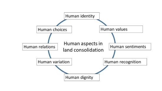
Figure 1. Human aspects in
land consolidation
Having identified and specified the fundamental human aspects of land
consolidation as part of a broader scientific notion of human geodesy,
the next step is to review how these aspects are inter-related, and what
kind of main principles can be posited such that the fundaments of human
geodesy are demarcated. This can be done using a number of
dichotomous questions, which can be connected to each of the aspects,
and which can derive a number of operational guidelines on when and how
to include human geodetic aspects in land consolidation projects.
4.1 Location specific or non-location specific insights
To a large extent human identity, human relations and human choices
are predominantly location-specific, because they all relate to a
specific feeling, belief of behavior which can be connected to a certain
area on the ground. Often this is translated in the name of the
community with which one identifies, a local dialect, or an historical
string of family relations. On top of that local choices may be strongly
determined by geomorphology and/or topography. In contrast, human
variation and human dignity are far less location specific because these
could apply to any location. Human dignity is for example used to state
that respect and appreciation should apply anywhere, and should be
treated equally in all areas. Finally, human sentiments are often
location specific, as they have to deal with specific reactions to plans
or types of communication, but at the same time this aspect is very
person dependent. There are simply people who express their sentiments
more or less regardless of the location of the context, despite the fact
that cultural theories would also make a difference between origins.
4.2 Long term versus short term insights
Another difference is related to the duration of particular aspects.
Human identity and human values are for example long-lived, whereas
human sentiments are much shorter lived. The implication of these
difference is that measuring and accounting for each aspect has to be
done at different time scales.
4.3 Land consolidation processes-related or non-process related
aspects
Each land consolidation process, big or small, guided or voluntary,
urban or rural, has a number of process steps. Hartvigsen (2015)
specifies the following generic process steps as: pre study, initiative
submitted to a government agency, initial public meeting, re-allotment
planning, project approval, preparation of registration, execution of
re-allotment and registration. Some of the aspects play a different role
in each of these generic process steps. The aspect of human identity
needs to be captured in the pre-study and is required in the
re-allotment planning. The goal is to conserve the identity and cultural
heritage and not to delete it through the land consolidation. The
aspects of human recognition is for example especially crucial during
the public meetings. All people need to be heard and equally taken
seriously. Human values are especially crucial in the project approval
stage, because it is at this stage that values which are intrinsic in
the new plan and which are explicit in the legislation are
institutionalized.
4.4 Automatic feature extraction and use of big data versus specific
data for each project
Some of the human aspects can be captured and/or assembled through
feature extraction of big data, including data collected through remote
sensing (Wagner and de Vries, 2019, Lee and de Vries, 2020). A synthesis
of twitter, facebook or Instagram message could for example evaluate
certain human sentiments and derive and/or predict operant value
systems. Similarly human relations could be derived from different
social network media, such as facebook (for private relations) or
Linkedin (for professional networks). In addition, many human values
could be captured by online value capturing tools such as Q Methodology
(de Vries, 2018) or through automated machine leanring from remote
sensing images. Hence, the collection of many human aspects are no
longer dependent on specific surveys and direct interviews, but can also
be collected through automated means.
5. CONCLUSION
Many of the human aspects in land consolidaiton are already
practiced. In that sense one could argue that if land consolidaiotn is a
human geodetic activity, human geodesy already exists implicitly,
because many practitioners in land consolidation tend to be geodesists
who implement projects using all kinds of human related concepts,
methods, techniques, epistemologies and axiologies. However, up
till now the scientific fundaments of human geodesy are still scattered
and undocumented. This paper provides a first overview of which aspects
are relevant for human geodetic practitioners, and also addresses how
and why these aspects are intrinsically connected to other concepts,
tools and techniques of the geodetic profession and the geodetic
science. For each of the aspects there exists a physical, mathematical
or engineering geodesy equivalent. This justifies that human geodesy is
connected and understandable from a geodetic perspective – rather than
from another disciplinary perspective. Given this, the goal of
specifying and unravelling these concepts in more detail is to start a
more fundamental discussion on the principal paradigms and basic
assumptions of human geodesy. Once these are derived, human geodesy can
be broadened and widened further with its own identity and a truly
recognized part of both geodesy (as an engineering science / discipline)
and human sciences. In addition, the description and
classification of aspects could be used for further empirical analysis.
6. REFERENCES
- ABUBAKARI, Z., VAN DER MOLEN, P., BENNETT, R. & KUUSAANA, E. D.
2016. Land consolidation, customary lands, and Ghana's Northern
Savannah Ecological Zone: An evaluation of the possibilities and
pitfalls. Land use policy, 54, 386-398.
- BENNETT, R. M., YIMER, F. A. & LEMMEN, C. 2015. Toward
Fit-for-Purpose Land Consolidation. Advances in Responsible Land
Administration. CRC Press.
- BENSON, K. 2016. The Anger Iceberg. Available:
https://www.gottman.com/blog/the-anger-iceberg/ (last date of
access: 6.5.2019).
- BULLARD, R. 2007. Land Consolidation and Rural Development.
Papers in Land Management. No. 10.
CASTLEMAN, T. 2013. Human recognition and economic development: An
introduction and theoretical model.
- CHANDRAN, R., HOPPE, R., DE VRIES, W. & GEORGIADOU, Y. 2015.
Conflicting policy beliefs and informational complexities in
designing a transboundary enforcement monitoring system. Journal of
cleaner production, 105, 447-460.
- DE VRIES, W. T. 2017. Human geodesy - shaping a new science and
profession for the world of tomorrow. FIG Working week 2017.
Helsinki, Finland.
- DE VRIES, W. T. 2018. Towards a theory of metagovernance of
land: fundamentals and prospects. Journal of land policy and
governance (JLPG), 1, 26-36.
- DE VRIES, W. T., BENDZKO, T., GJORGJIEV, G. & MALIJANSKA, N.
2018. Comparing land consolidation history and future – case studies
Bavaria/Germany and Republic Macedonia. Report for BAYHOST funded
project MB-2018-2/12 ‘Flurbereinigung in Theorie und Praxis - eine
Vergleichsstudie Bayern- Mazedonien’. . TU Munich, Chair of Land
Management.
- DE VRIES, W. T., BENNETT, R. M. & ZEVENBERGEN, J. 2015. Toward
Responsible Land Administration. Advances in Responsible Land
Administration. CRC Press.
- DE VRIES, W. T. & CHIGBU, U. E. 2017. Responsible land
management - Concept and application in a territorial rural context.
fub. Flächenmanagement und Bodenordnung, 79, 65-73.
- DE VRIES, W. T., WOUTERS, R. & KONTTINEN, K. 2019. A comparative
analysis of senior expert experiences with land consolidation
projects and programs in Europe. FIG Working week 2019, Geospatial
information for a smarter life and environmental resilience. Hanoi,
Vietnam.
- DE VRIES, W. T. & ZEVENBERGEN, J. A. 2011. Discretionary space
as a concept to review innovation in land administration in Africa.
Survey review, 43, 638-652.
- DEMETRIOU, D., SEE, L. & STILLWELL, J. 2013. A parcel shape
index for use in land consolidation planning. Transactions in GIS,
17, 861-882.
- FAO 2003. The design of land consolidation pilot projects in
Central and Eastern Europe. In: FAO (ed.).
- FAO 2004. Operations manual for land consolidation pilot
projects in Central and Eastern Europe. Rome: Food and agiculture
organization of the United Nations (FAO).
- GOLUBOVIĆ, Z. 2011. An anthropological conceptualisation of
identity. Synthesis philosophica, 26, 25-43.
- GUGGEMOS, A. 2018. Bayrische Flurneuordnung in Theorie und
Praxis. Bachelor, Technical University of Munich.
- HARTVIGSEN, M. 2014. Land reform and land fragmentation in
Central and Eastern Europe. Land Use Policy, 36, 330-341.
- HARTVIGSEN, M. B. 2015. Land Reform and Land Consolidation in
Central and Eastern Europe after 1989: Experiences and Perspectives.
Videnbasen for Aalborg UniversitetVBN, Aalborg UniversitetAalborg
University, Det Teknisk-Naturvidenskabelige FakultetThe Faculty of
Engineering and Science.
- KRUPOWICZ, W., CZARNECKA, A. & GRUS, M. 2019. Possibilities of
implementing crowdsourcing initiatives in rural development
programmes in Poland. FIG Working Week 2019. Geospatial information
for a smarter life and environmental resilience. Hanoi, Vietnam,
April 22–26, 2019.
- LEE, C. & DE VRIES, W. T. 2020. Bridging the Semantic Gap
between Land Tenure and EO Data: Conceptual and Methodological
Underpinnings for a Geospatially Informed Analysis. Remote Sensing,
12, 255.
- LOUWSMA, M. & LEMMEN, C. 2015. Relevance of leased land in land
consolidation. FIG Working week - From wisdom of the ages to the
challenges of the modern world. Sofia, Bulgaria.
- LOUWSMA, M., VAN BEEK, M. & HOEVE, B. 2014. A new approach:
Participatory Land Consolidation XXV FIG Congress, 16-21 June 2014,
Kuala Lumpur, Malaysia. FIG, 2014.
- MAGEL , H. & MIOSGA, M. 2015. Philosophische Grundlagen zur
Chancengleichheit. Welcher Begriff von Gerechtigkeit wird dabei
zugrunde gelegt? . 3rd session of Enquete-Commission
„Gleichwertige Lebensverhältnisse in ganz Bayern“ (27.01.2015).
- MCLAREN, R., ENEMARK, S. & LEMMEN, C. Guiding Principles for
Building Fit-For-Purpose Land Administration Systems in Developing
Countries: Capacity Development, Change Management and Project
Delivery. Recovery from Disaster, 2016. International
Federation of Surveyors.
- NTIHINYURWA, P. D., DE VRIES, W. T., CHIGBU, U. E. &
DUKWIYIMPUHWE, P. A. 2019. The positive impacts of farm land
fragmentation in Rwanda. Land Use Policy, 81, 565-581.
- SAVOIU, C., LEMMEN, C. & SAVOIU, I. 2015. Systematic
Registration in Romania a New Opportunity for Land Consolidation.
FIG Working Week - From the wisdom of the ages to the challenges of
the modern world. Sofia, Bulgaria.
- VITIKAINEN, A. 2004. An overview of land consolidation in
Europe. nordic Journal of Surveying and real Estate research, 1.
- WAGNER, M. & DE VRIES, W. T. 2019. Comparative Review of Methods
Supporting Decision-Making in Urban Development and Land Management.
Land, 8, 123.
BIOGRAPHICAL NOTES
Prof. dr. ir Walter Timo de Vries, wt.de-vries@tum.de , is chair land
management and Study Dean Geodesy and Geoinformation at the department
of Aerospace and Geodesy at the Technical University Munich. His
research interests include smart and responsible land management, public
sector cooperation with geoICT and capacity development for land policy.
Key themes in his most recent publications advances in responsible and
smart land management and land administration, land consolidation, urban
and rural development and neocadastres.
CONTACTS
Walter Timo de Vries
Technical University of Munich
Lehrstuhl für Bodenordnung und Landentwicklung / Chair of Land
Management
Department of Aerospace and Geodesy
Arcisstraße 21, 80333 München
GERMANY
Tel. +49 89 289 25799
Website:
https://www.lrg.tum.de/bole/startseite/


