FIG Commission 8
|
Work Plan 2019-2022
 Original Work Plan in -pdf-format
Terms of Reference
- Spatial planning policy, implementation, monitoring and evaluation
- Land policy instrumentation for the implementation of spatial plans
- GIS tooling in spatial planning
- Rural-urban relations and dependencies
- Participatory and inclusive planning processes
- Urbanization patterns and development strategies
- Valuation in spatial planning and land use change
- Sustainable development
Mission statement
In a world of limited resources, of which land is the most prominent in
the domain of spatial planning, the mission of commission 8 is to provide
access to planning processes for all and balance the various interests in
pursue of a sustainable spatial development at all governance levels both
for the short- and long-term.
General
Changing urbanisation patterns, increasing climate extremes, technical
developments, changing social and economic demands, rural-urban
dependencies, and the need for sustainable development, to mention just a
few developments, all pose a pressure on land use and its spatial
distribution. Spatial planning is closely related to tenure as spatial
developments, planned or unplanned, affect land use, land owners and its
users. From this perspective, commission 8 wants to connect scientists,
professionals, and practitioners from all backgrounds to foster a
sustainable development at all scales (local, regional, national,
supra-national).
Different localities face different developments and will respond
differently to them. This commission aims to provide a platform for the
spatial planning community to share and discuss such differences, and
similarities of course, and find ways to respond to them, develop principles
of good governance and embed them in planning practice. These will draw on
established guidelines or principles such as the Sustainable Development
Goals (SDG’s), the Voluntary Guidelines on the Responsible Governance of
Tenure of Land, Fisheries and Forests in the Context of National Food
Security (VGGT), Fit-for-Purpose Land Administration (FFP) or Participatory
and Inclusive Land Readjustment (PILaR).
The development of policies to guide spatial development is at the heart
of the domain, but we also pay attention to ways to implement these
policies. Participatory processes will provide a voice to stakeholders in
the dialogue between stakeholders and governments. Furthermore, ongoing
technical developments open up possibilities to support planning processes
with GIS tools or egovernment applications. As the saying goes, a map tells
more than a thousand words. One of the challenges is to appropriately
integrate GIS tools into planning processes and connect to the system of
available data sets.
Additionally, it is important to have a look at the instruments
(instrumentation) that governments have at their disposal to implement
spatial policies and in particular land use change. Land consolidation, land
readjustment, compulsory purchase / expropriation / eminent domain, land
banking, pre-emption rights, and similar land policy instruments all use or
affect land rights to realise the planned spatial development. Because of
their impact on land rights, land policy instrumentation should be used
thoughtfully to guarantee legal certainty for involved stakeholders.
In the period 2019-2022, the focus of commission 8 will be:
- To discuss strategies for the short- and long-term in the cycle of
policy development, implementation, monitoring and evaluation.
- To investigate the role of land policy instrumentation to implement
planned spatial development.
- To promote and advance the use of GIS tools in participatory spatial
planning processes (cooperation with commission 3).
- To investigate rural-urban relations and dependencies and raise
awareness in planning issues for SMART solutions.
- To discuss urbanization patterns, development strategies and their
effects on communities (cooperation with commission 7).
- To investigate valuation in spatial planning related to land use
change (cooperation with commission 9).
- To foster awareness for well-balanced planning decisions to support
sustainable development (ecologically, economically, socially).
Working Groups
Working Group 8.1 Rural – urban dependency
Introduction
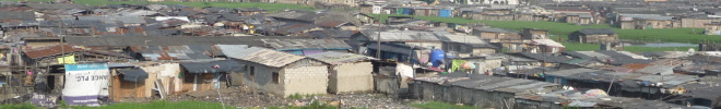
Rural and urban (including peri-urban) areas are important for
development, because all over the world they provide space for people to
live. They face similar development challenges, although differences exist
as well, and therefore have common needs in terms of development Figure 1).

Figure 1 Challenges and common needs of rural and urban areas
Both rural and urban areas co-exist for mutual benefits because
rural resources are needed in urban areas and urban resources are needed in
rural areas. There has been a big focus on urban development – especially
concerning the development of sustainable, green and smart cities – with
less attention paid to rural development. While the focus on urbanisation is
understandable, spatial planning (and development) demands a balance (and
continuum) between rural and urban development. From this perspective, rural
areas deserve similar attention for them to become more liveable places.
With appropriate spatial planning (and development) concepts and approaches,
rural and urban areas can become socially and technologically smart spatial
units. However, this is only possible if they are investigated from a
continuum lens – with focus on their socio-spatial interdependencies and
interrelationships.
Policy Issues
- Investigate rural – urban relations and dependencies that affect
sustainable spatial development.
- Identify key developments in rural areas, such as depopulation,
rural land market or food security, to be addressed in a SMART way.
- Investigate approaches to urban and rural development and recommend
or innovate approaches that are responsive to the urban-rural continuum
of development.
Chair
Rosy Liao Rong (China)
rosyliao[at]outlook.com
Dr.-Ing. Michael Klaus (Germany)
klaus[at]hss.de
Mr. Eugene Chigbu (Germany)
ue.chigbu[at]tum.de
Working Group 8.2 GIS tools for spatial planning (joint Working Group
with commission 3)
Introduction
GIS tools hold great potential to support spatial planning practice.
Ongoing developments in digitalization of data sets and communities further
open up possibilities to apply GIS tools in spatial planning processes. The
latter typically follow a cyclic pattern: (1) development of spatial
policies, (2) policy implementation, and (3) monitoring and evaluation
(Figure 2). Spatial policies range from strategic visions to land use plans
that at operational level determine and distribute land use types. Together
with legislation and rules, these spatial policies constitute the framework
for implementation of spatial policies. Programmes, projects, enforcement
mechanisms and the like can be used to implement spatial policies, depending
on the situational context. Finally, monitoring and evaluation is necessary
to measure whether policy aims are met or need to be adapted, which may lead
to the development of new spatial policies.
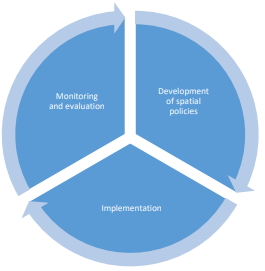
Figure 2 Spatial planning cycle
Due to the different nature of each phase in the cycle, GIS tools to
support spatial planning practice will require different data
specifications, functionality and usability features. This working group
aims to gain a better understanding of developing useful GIS tools given a
particular planning exercise, based on the different phases in the spatial
planning cycle. Having appropriate and user friendly GIS tools available
will create a positive spin-off in terms of enhancing information
transparency and increase inclusiveness among participating stakeholders.
Policy issues
- Examine current GIS tools used in spatial planning practice and
consider the potential role for future applications.
- Develop guidelines based on best practices regarding data standards,
functionality and usability of GIS tools.
- Encourage the use of spatial information and public participation in
spatial planning by using e-government.
- Foster transparency, inclusiveness and legal certainty in
decision-making by providing tools for stakeholders to access
information and participate in spatial planning processes.
Chair
Enrico Rispoli (Italy)
e.rispoli[at]cng.it
Adriana Czarnecka (Poland)
Adrianna.Czarnecka[at]pw.edu.pl
Joint Working Group – Urban Challenges (Joint Working Group with
Commission 7 and 9)
Introduction
According to the United Nations1 urbanization prospects, by 2050 68 % of
the world’s population will be living in urban areas. To ensure a
sustainable development and ensure access to services for all, including the
vulnerable, requires considerable effort from all involved. It touches upon
themes such as urban resilience (social well-being, health, services,
climate), informal settlements, affordable housing and financial
sustainability among others.
Policy issues
- Scope and analyse current and future challenges for communities in
small, medium, large, and megacities, in terms of urban resilience,
climate change, housing and informal settlements, and fiscal health.
- Investigate principles of traditional tribal communalism and
understand how those principles can be successfully reintroduced into
contemporary residential development.
- Explore current practices around the globe for tackling urban
housing issues and combine existing research which forecast future
practices.
- Investigate critical success factors of existing high-density living
arrangements (environmental, social, legal, etc).
- Contribute to the dissemination of best practices of how spatial
planning can contribute to address the present and future urban
challenges.
- Investigate the potential contribution of land-based finance to
addressing these urban challenges.
- Develop an audit tool for the assessment of sustainable municipal
finance, fiscal health and land-based value capture tools in relation to
the urban challenges.
- Posit alternative future design models and provide guidance for
governments, municipalities, communities and professionals on
incorporating these models into current practises for sustainable,
spatially informed, and sociable city-living.
Chair
Erwin van der Krabben (Netherlands)
e.vanderkrabben[at]fm.ru.nl
James Berghan (New Zealand)
james.berghan[at]postgrad.otago.ac.nz
Claire Buxton (New Zealand)
clairelouisebuxton[at]gmail.com
Working Group 8.4 Land policy instruments for spatial development
Introduction
Land, being a limited resource, requires some form of land management to
foster a sustainable development. Demand for land, for instance for food
production, housing, nature conservation, or infrastructure, surpasses
supply. Moreover, supply of appropriate land does not necessarily meet
demands regarding its spatial distribution. This working group focuses on
international available land policy instruments that may support
stakeholders, mostly governments, upon the implementation of spatial
policies and spatial redistribution of land to foster a sustainable spatial
development.
Policy Issues
- Analyse available land policy instrumentation, such as land banking,
expropriation, land consolidation, land readjustment, expropriation,
pre-emption rights to implement spatial objectives for a sustainable
development.
- Foster the dissemination of international practice of land policy
instruments and their applications.
- Establish and distribute a generic legislative framework for land
consolidation.
- Develop and describe a generic process for land consolidation to
foster the development of a generic and modifiable open source GIS tool
to support the implementation of land consolidation in various
countries.
Chair
Dr. Morten Hartvigsen (Hungary)
morten.hartvigsen[at]fao.org
Prof. dr. Walter de Vries (Germany)
wt.de-vries[at]tum.de
Ms. Wioleta Krupowicz (Poland)
wioleta.krupowicz[at]pw.edu.pl
Mr. Rodrigue Bazame (Turkey)
Rodrigue.Bazame[at]ankara.edu.tr
Working Group 8.5 African Water Governance
Introduction
Resilience applies to both the industrialised and less-industrialised
parts of the world and is associated with many aspects of human activity,
often responding to the effects of climate change. It could be related to
food, water, land, or energy scarcities. It could relate to living by the
coast and the threat of sea level rise and storm surges, or in mountainous
areas threatened by glacial deluge, or in arid areas with erratic rainfall,
or on small or low-lying islands facing increasingly violent storms. It
could also relate to living in rural areas or in urban situations. Whenever
and wherever there is a threat of a natural hazard (such as flooding,
drought, heatwave), then there is an associated need to be resilient to
“come back” after the effects of that hazard have been endured.
Development gains can be quickly wiped out by a natural disaster
directly, a surge in prices (as a consequence of a disaster), or a resource
conflict. Gains could also be undermined over time by the cumulative effects
of stressors such as climate change; environmental degradation; water, food,
and energy scarcity; and economic uncertainty. While humanitarian responses
to crises have saved lives and helped to restore livelihoods, such efforts
have not always addressed underlying vulnerabilities. A resilience-building
approach helps to address the damaging effects of shocks and stressors
before, during, and after crises, thereby minimising human suffering and
economic loss. The ability and capacity to “come back” is a measure of the
individual or collective resilience. In this working group, we focus on
resilience in urbanised areas in Africa from a water governance perspective
and the role of surveyors.
Policy Issues
- Scope and analyse current and future challenges for communities in
small, medium, large, and megacities, in terms of the resilience of
water governance;
- Investigate the principles of conventional water governance and
understand how those principles could be re-configured or aligned with
climate change imperatives;
- Explore current practices around Africa for managing water resources
and combine with climate change predictions and population growth
scenarios;
- Investigate and document critical success factors when managing
water resources;
- Contribute to the dissemination of good practice in managing water
resources for resilience; and
- Propose alternative future scenario strategies for managing water
resources and provide guidance to governments, municipalities,
communities and professionals on reflecting these potential futures into
current practice for sustainable, spatially-informed water governance.
Chair
Richard Pagett (Serbia)
secure[at]richardpagett.com
Isaac Boateng (Ghana)
isaac.boateng[at]uew.edu.gh
|


