FIG PUBLICATION NO. 76
International Boundaries on Unstable Ground
FIG Commission 1 - Professional Standards and Practice
FIG REPORT
Editor:
Haim Srebro
Authors:
Dr. Haim Srebro
Prof. Andrea Cantile
Prof. Don Grant
Dr. William (Bill) Robertson
Vincent Belgrave
PREFACE
“ Borders“, “demarcation lines“ or “frontiers“ are on one hand evoking
negative associations like separation and segregation. But on the other hand
they also serve for good being often the basement of a peaceful and life
together with our neighbours. In the latter sense each borderline is also an
important element of a prosperous coexistence. The legal act of
establishment and recognition of borders between private properties is
normally regulated in the national law based on a common understanding and
on one constitution.
Defining, establishing and maintaining international boundaries is a very
demanding task. The underlying legal framework is more complex. Several
states with different constitutions and varying legal opinions are involved.
International agreements are the base for the recognition of a border
between two or more states.
This FIG Publication on International Boundaries on Unstable Ground is a
supplement and extension to FIG Publication 59 on International Boundary
Making, published in 2013. Both publications are edited by Haim Srebro. The
authors Vincent Belgrave, Andrea Cantile, Donald Grant, William A. Robertson
and Haim Srebro are all highly qualified experts and practitioners in
“boundary making”. In this issue they focused on the boundaries in rivers
and lakes and on the boundaries on unstable ground especially on glaciers
and in conjunction with tectonic plate movements.
This publication is a fine and profound supplement to publication 59. It
also covers the new challenge of precise GNSS-measurements in conjunction
with international borders.
FIG thanks the authors for their valuable contribution as international
experts of boundary-makers. We hope that this publication will be an
informative guide for the definition of future international borders.
Rudolf Staiger
FIG President 2019–2022
My sincere thanks to Dr. Haim Srebro, Chair of Working Group 1.3
International Boundary Settlement and Demarcation for writing the
International Boundaries on Unstable Ground as a supplement to the
International Boundary Making to promote just, peace and inclusive societies
throughout the world and achieve the United Nations Sustainable Development
Goal No. 16 on Peace, Justice and Strong Institutions.
Winnie Shiu
Chair Commission 1 (2019–2022)
Introduction
This FIG Publication on International Boundaries on Unstable Ground is a
supplement and extension to FIG
Publication 59 on International Boundary Making. Publication no. 59
mainly elaborated on the process of international boundary making, including
allocation, delimitation in an agreement, demarcation, survey and
documentation, and boundary maintenance. In addition, the publication
elaborated on the joint professional support of the boundary making process.
The practical parts mainly referred to land boundaries. The specified goal
of the process being to achieve a long lasting stable agreed boundary line.
The main implementations of territorial boundary delimitation are
demarcation of international boundaries and demarcation of internal
boundaries in states, including administrative boundaries and boundaries
delimiting land properties and rights of use. The cadastral boundaries are
important for ensuring stable legal territorial matters. In order to fulfil
the specific requirements of boundary making in these cases, the law
requires fixed unequivocal and unambiguous defining of the boundary lines.
The goal of stability of an international boundary is very important. It
is the leading essence of the boundary line in order to enable peaceful and
productive environment, including safe legal order and arrangements on both
sides of the boundary. The goal of stability of international boundaries has
been defined by the International Court of Justice[1].
The ICJ has confirmed principles of stability of boundaries. Yet, the main
practical principles regarding this issue refer to stability of land
boundaries, including respecting of boundary markers as such by the states
concerned.
Part of the problems of boundary delimitations resulted from selection of
insufficient or unstable features, either artificial man-made changing
features like roads, or common natural geographic features that have been
chosen for delimitation of boundary lines. Such are boundaries along
mountain crests and water sheds, as well as on dynamic earth's physiographic
features, such as rivers, glaciers, lakes, marshes, shorelines, edges of
deserts, and even boundaries on dynamic land moving due to tectonic
activities.
While demarcation problems along mountain crests are usually a result of
vague delimitation that faces the detailed character of the real world, such
as cases where a boundary line along mountain crests crosses valleys between
mountains, or in cases where the high crests do not coincide with the
general watershed line. Other demarcation problems depend on the dynamic
character of chosen natural geographic features. Such are rivers and
shorelines that change every second and along the year. The origin of many
natural geographic feature based problems is an outcome of climate changes
and global warming. Many others are a result of man-made activities.
The main problems due to global warming refer to boundary lines delimited
with reference to water bodies: river boundaries, boundaries in lakes and
marshes, boundaries along shorelines, and boundaries on glaciers. Rivers,
lakes and marshes lose water and dry. Global warming causes lakes and
marshes to shrink and in some cases to disappear. It causes glaciers to melt
so that the under glacier base ground is exposed gradually. Since the
boundary line on glaciers used to be delimited along the crests of the
glaciers, the result of the melting process of the icy natural crests is
that the newly exposed bare rocky mountain crests are located in different
locations than the icy crests. Since the boundary line used to be delimited
along the icy crests the neighboring parties have to define where should be
located the new boundary.
The cases of river boundaries are much more diverse and much more
widespread. More than one third of the international boundaries throughout
the world are river boundaries. The impact of the drying process of rivers
due to global warming is combined with the influence of the population
growth all over the world and with artificial man-made works along rivers.
Water supply is the most essential natural resource required for human
living and therefore a large part of the global population lives along
rivers. The need for water leads to development of large artificial water
projects on rivers, sometimes building big dams and reservoirs, changing
dramatically the natural water flow of the river downstream, and changing
its natural balance and behavior. The water flow of a river may also be used
for the production of energy, building hydroelectric power stations, with
dams, reservoirs and other works and installations that change the natural
behavior of rivers. These phenomena complicates the maintenance of
boundaries in rivers, especially due to the trend used in many boundary
agreements that the boundary follows continuous gradual natural changes in
the river (accretion) and does not follow artificial changes in the river.
The extent of man-made influence on the river flow all over the world leads
to severe problems regarding boundaries in rivers everywhere. This reflects
severe disadvantages of choosing natural geographic features for
international boundary delimitations in the past, and especially for the
common trend of using rivers as international boundaries.
Jones, in his remarkable hand book on boundary-making already recommended
in 1945 (Jones, 1945) to avoid the use of natural geographic features, and
especially rivers for boundary delimitation.
Unfortunately, natural geographic features, and especially rivers, were
widely used by the colonial powers for boundary delimitations during the
second half of the 19th century and the first half of the 20th century.
Holdich, who participated in implementing this approach of the British
Administration explained the advantages of this approach (Holdich, 2016),
and while not ignoring disadvantages in certain cases, praised the use of
rivers for delimitation in many cases by the words: "It is a God-sent
feature for boundary-making". He explained the advantages of natural
bound€aries over artificial boundaries a century ago: "They are readily
delimitated and demarcated; they are inexpensive and immovable; they last
well under conditions of climate, and they are, as a rule, plain and
unmistakable." Unfortunately, the numerous cases of disputes regarding past
delimitation of natural boundaries, and especially river boundaries, show
big disadvantages of natural boundaries. Part of it is a result of global
warming and global population growth. Fortunately, since the situation a
century ago, the development of improved mapping infrastructure all over the
world, and the development of high quality mapping technology and systems,
including the use of satellites for real time accurate global positioning
all over the world, supplies much better tools for precise boundary
delimitation and demarcation.
Since FIG is a global NGO organization that integrates various kinds of
professions regarding surveying, geodesy and additional close professional
fields, including many practitioners from the member organizations, many
people from the academic world, and people from affiliate national
organizations, we have chosen in FIG Publication no. 59 an approach that
combines theoretical and methodological parts and practical cases over the
world. The practical cases in publication 59 referred to boundaries in the
Middle East, with the outstanding Israel-Jordan boundary that fully
implemented the methodological model; the Iraq-Kuwait boundary that was
demarcated by the UN itself; case in Africa, including the Ethiopia-Eritrea,
Cameroon-Nigeria and Sudan-South Sudan Abyei boundaries, all of which were
relatively new delimited boundaries. In addition, it included old delimited
boundaries between Nepal and India and China. Thus, it included both the
international boundary in the lowest place on Earth (The Dead Sea) and the
highest place on Earth (Mount Everest). We continue with the same approach
in the current publication which is a supplement to Publication No. 59.
Regarding river boundaries we bring the practical case of the Jordan River,
the lowest river on Earth in its southern section, south of the Sea of
Galilee, flowing to the Dead Sea from about -220m to -430m (below sea
level). The Jordan River flows along the Dead Sea Rift along the tectonic
border between the African Plate on the west side and the Arab Plate on the
east side until it flows into the Dead Sea. The practical cases of
boundaries on glaciers were chosen along the Italian-Swiss and the
Italian-Austrian boundaries on the Alps in Europe. The reason for that was
the special approach of the moving border that has been adopted in these
cases. An example of the influence of tectonic plate movement on the
demarcation of an international boundary is shown in a review of the
Iraq-Kuwait boundary demarcation after 20 years.
It is worth mentioning that natural fenomena that influence the stability
of international boundaries are sometimes interrelated. Movement of tectonic
plates along the course of a river may directly influence its course, or
indirectly because of collapses of its walls that block its flow, enforcing
it to find or create a bypass. Such is the case of the Jordan River. The
melting of glaciers, that influences the boundary line along crests, may
also have an influence on the boundary line in a lake in the case that there
is a boundary line in the lake, by causing a rise of the water level and
horizontal changes in the coastlines of the lake. In the case of a river and
a lake that both serve for boundary delimitation, if the lake partially
dries, the river has to find or create a new channel through the dried area
in order to get to the lake. This new channel is usually not identical with
the old boundary line in the drying lake. Such is the situation between the
Jordan River and the Dead Sea.
Part 1, Chapters 1, 2 and 3, deals with boundaries in rivers and lakes.
Chapters 1 and 2 deal with river boundaries. Chapter 1 elaborates on
methodological aspects regarding river boundaries. Chapter 2 elaborates on
the practical case of the international boundary between Israel and Jordan,
in its river section that follows the Jordan and Yarmuk Rivers. The article
describes changes in the two rivers during the last century, as a result of
natural and artificial changes and analyzes the influence of these changes
on the international and cadastral boundaries. Chapter 3 deals with
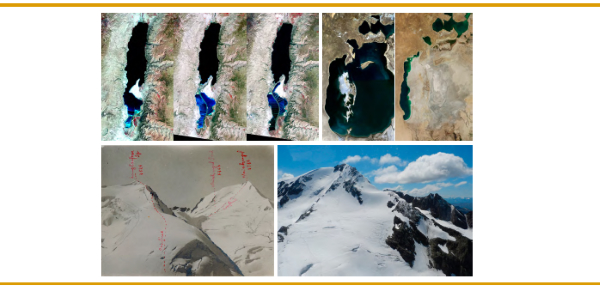
boundaries in lakes, showing examples of the shrinking of the Aral Sea and
Lake Chad, and elaborating on the example of the changes in the Dead Sea
level and shores due to global warming and man-made influence.
Chapter 4 deals with the international boundaries of Italy, describing
the boundaries between Italy and Switzerland and Austria on the glaciers of
the Alps. It describes and analyzes the continuous gradual process of
melting of the ice over the last century as a result of global warming. The
original agreed delimitation of the international boundaries between the
relevant states was along the crests of the mountains that used to be icy
crests. The melting of the ice exposed the rocky crests that used to be
beneath the ice. Since the exposed rocky crests follow different locations
than the original delimitation and demarcation on the crests of the
glaciers, the neighboring states face a problem: Should the boundary follow
the old historic delimitation of the boundary or should it move to the newly
exposed crest of the mountain. The article analyzes the process of
negotiations between the concerning parties and introduces the chosen
solution called the moving border.
Chapters 5 and 6 deal with the uncertainty of delimitation and
demarcation of international boundaries on the long run, including land
boundaries all over the world, due to dynamic plate movement. Chapter 5
looks at the geodetic and geophysical issues that earth dynamics may impose
on the reliable enduring definition of international boundaries, being aware
that no place on the surface of the Earth can be truly considered to be
fixed in place due to pervasive tectonic motion. The practical case of the
Iraq-Kuwait Boundary shows that despite an initial coordinate accuracy of 2
cm, the global positional accuracy has been degraded to meters during only
20 years. Chapter 6 reviews surveying standards and datums used to support
international boundary positioning and documentation. Poor boundary
delimitations, including poor maps, may contribute in the future to
instability of the boundary and to boundary conflicts. The article
elaborates on the pervasive use of satellite positioning during the last
decades for international boundary delimitations. It refers to the problem
to maintain on the long run permanent stability of international boundary
monuments and coordinates, arguing that local reference systems may not be
adequate for maintaining the stability of international boundaries. The
author suggests that the delimitation, demarcation and maintenance of
international boundaries would be future proofed by being connected to a
regional densification of ITRF. In addition, for future consistency, the
ellipsoid for calculations, the datum and the coordinates for calculations,
as well as the long term adjustment to the ITRF could be a standard
requirement in the technical specifications of all international boundary
agreements.
The publication has been prepared by senior practical professionals, with
expertise in boundary delimitation, demarcation and documentation. Three of
them served as Director Generals of national surveying and mapping
organizations (Dr. Haim Srebro in Israel and Dr. William Robertson and Prof.
Donald Grant in New Zealand), one served as a chief geographer in a national
organization (Dr. Andrea Cantile in Italy), and one (Vincent Belgrave) was
a chief surveyor in a few UN missions regarding boundary settlement. All of
the authors have long practice in international boundary settlement and
demarcation.
This FIG Publication has been prepared under the framework of the FIG
Commission 1: Professional Standards and Practice work plan for 2018-2022
(Commission Chair: Winnie Shiou. Chair of WG 1.3 on International Boundary
Settlement and Demarcation: Dr. Haim Srebro). Special thanks to the
honorable Prof. Moshe Brawer for peer reviewing the entire publication and
adding useful remarks. The publication is intended to promote the sharing of
methodological knowledge and experience regarding delimitation of
international boundaries and to promote Peace throughout the world.
Haim Srebro, Editor
Chair, FIG Commission 1 Working Group on International Boundary Settlement
and Demarcation
September 2020
[1] Case concerning The Temple of Prea Vihear
[Merits], 1962 ICJ Reports 6.
Read the full FIG Publication 76 in pdf
Copyright © The International Federation of Surveyors (FIG),
December 2020.
All rights reserved.
International Federation of Surveyors (FIG)
Kalvebod Brygge 31–33
DK-1780 Copenhagen V
DENMARK
Tel. + 45 38 86 10 81
E-mail: FIG@FIG.net
www.fig.net
Published in English
Copenhagen, Denmark
ISSN 1018-6530 (printed)
ISSN 2311-8423 (pdf)
ISBN 978-87-92853-22-6 (printed)
ISBN 978-87-92853-30-1 (pdf)
Published by
International Federation of Surveyors (FIG)
Layout: Lagarto
|