Please note, your registration to the FIG e-Working Week also includes your participation in one or more of the workshops.
The ArcGIS Parcel Fabric is designed for any organization in any country or region that manages cadastral / land records. The ArcGIS Parcel Fabric is the system of record of the rights, restrictions, and responsibilities of Land. It uses record-driven workflows that organizes parcel data based on the form in which it is originally recorded.
Beyond cadastral agencies the assessor offices this includes Public Works departments, Federal agencies, Right-of-Way mapping for Transportation, Railroads, Pipeline, and Utility companies. Lease mapping for oil/gas, forestry, and agriculture. Lease and Land management for Port authorities.
The workshop will include demonstrations and hands-on exercises.
Workshop Topics include:
By Mr. Nikolaus Studnicka, RIEGL Manager Terrestrial Laser Scanning Business Division
In practical use the RIEGL VZ-400i laser scanner proves daily that it is one of the fastest in its class. Up to 400 scan positions can be recorded in an 8-hour working day and are already registered to each other during data acquisition. High-resolution photos are taken in parallel. This workshop will show - even to newcomers - how a single operator can handle such an extensive scanning project. It starts with data acquisition, which is extremely fast, both outdoors and indoors (even without light and GPS reception). Already during scanning, it is possible to follow on a mobile device how the scan positions combine to form a floor plan. Back in the office, the data can be transferred into a homogenized and balanced point cloud using the newly developed "One-Touch-Processing-Wizard". In the workshop, the entire workflow is displayed, questions arising will be discussed and answered.
The increasing complexity of densely built-up areas and infra-structures (3D Land Uses) requires the proper registration of the legal status of built environment (private and public), which only can be provided to a limited extent by the existing 2D representations. 3D representations of legal space can be seen in other steps of the spatial development: planning, design, permitting, constructing, enforcement, and so on. 3D data sharing and reuse are topics of growing importance. The information infrastructure is a tool to realize data sharing by networked connectivity and improved interoperability. Standards play a crucial role in the information infrastructure, and specifically the earlier mentioned LADM (ISO 19152:2012). This standard has been in use for eight years by now, and the ISO TC211 members decided that the standard is up for revision and should address land administration with a wider scope, such as valuation, spatial planning (planned land use), marine spaces and with more detailed 3D representations.
The workshop will focus on the latest innovations and developments in 3D Land Administration and on the developments related to the Land Administration Domain Model. The workshops aims to involve relevant FIG Commissions in the development of LADM Edition II. The decision to publish LADM Edition II as multipart had as a consequence that a New Working Items Proposal (NWIP) and a Working Draft (WD) have to be formulated for each Part. It is expected that this can be done with the cooperation of relevant commissions, the FIG Standards Network and external organisations. It means a real contribution, so work has to be done.
|
08.00-09.30 CET |
Session 1 -
3D LA and LADM, part I
|
|
13.00-14.30 CET |
Session 2 - LADM Implementations
|
|
15.00-16.30 CET |
Session 3 - 3D LA and LADM, part II
|
|
20.00-21.30 CET |
Session 4 - LADM Standards Developments
|
Well organised land administration systems can support countries achieving sustainable development. They can support responsible land policies and land management strategies, assist land dispute reduction, enable fair investment opportunities, support social and spatial justice, and overall good governance. However, a large number of people-to-land relationships (read: tenures) are unaccounted for in formal land administration systems, especially in the developing countries. This undermines equity, equality and the achievement of the Sustainable Development Goals (SDGs). Conventional surveying approaches face diverse challenges in costs and time needed to comes to scaling and completion of land administration systems. Fit for Purpose approaches challenge the earlier paradigm. They seek lower costs, less recording time, and appropriate spatial data qualities. With FFP-LA having now being on the FIG agenda for almost a decade, this workshop session will reflect the successes, challenges, and future directions of the FFP-LA approach.
The subjects of the episodes in this workshop concern ‘best practises’, ‘tools’ and ‘concepts’. Those subjects are introduced during the keynote session on FFP-LA on June 22nd 2021.
Purpose of the Workshop: This workshop aims to support identification of strategies, methods, and tools for the scaling up of Fit-For-Purpose Land Administration through knowledge sharing around the Fit-for-Purpose Land Administration (FFP-LA) applications.
The workshop further aims to explore the pros and cons of FFP-LA, based on experience gathered through practical implementations. The workshop offers a platform for stakeholders (practitioners, academists and policy makers and a link between stakeholders. It is important that we build the capacity for newly adapted approaches. We need best practice examples.
Results of the workshop:
|
11:00-12:30 CET |
FFPLA Workshop - Episode 1: FFP-LA ‘best practises’,
‘tools’ and ‘concepts’ Episode 1 will focus on FFP-LA ‘best practises’, ‘tools’ and ‘concepts’. The episode will start with short, dynamic presentations followed by a workshop discussion, there can also be a short demonstration. Presenters are invited to spend attention to contribute to approaches for upscaling the FFP LA approach. Steven Mekking (Netherlands), Victorien Dossa Kougblenou (Benin), Martinus Vranken (Netherlands), Fabrice Gilles Kossou (Benin) and Christelle Van den Berg (Netherlands): Danilo Antonio, John Gitau, Hellen Nyamweru-Ndungu and Solomon Njogu (Kenya): Tarek Zein (Germany): Mila Koeva (Netherlands): Jean_Phillip Lestang (France): Trias Aditya (Indonesia): |
|
15:00-16:30 CET |
FFPLA Workshop - Episode 2: FFP-LA ‘best practises’,
‘tools’ and ‘concepts’ Episode 2 will focus on FFP-LA ‘best practises’, ‘tools’ and ‘concepts’. The episode will start with short, dynamic presentations followed by a workshop discussion, there can also be a short demonstration. Presenters are invited to spend attention to contribute to approaches for upscaling the FFP LA approach. Bastiaan Reydon (Netherlands): Stig Enemark (Denmark), Robin McLaren (United Kingdom) and Christiaan Lemmen (Netherlands): Michael Barry (Canada): Paula Dijkstra (Netherlands): Kwame Tenadu (Ghana): |
|
19:00-20:30 CET |
FFPLA Workshop - Episode 3: FFP LA ‘best practises’,
‘tools’ and ‘concepts’ Amir Bar-Maor (Netherlands): Amy Coughenour Betancourt (USA): Markus Koper (Germany), Andy Wickless (USA) and Martin Westers (Germany): Thomas Vintges and Lisette Meij (Netherlands): Bastiaan Reydon, Mathilde Molendijk (Netherlands), Piet Spijkers (Colombia) and Gabriel Siqueira (Brazil): Brent Jones (USA): |
Organised by Christian Clemen, Germany, HTW Dresden, DVW Germany
Scope of the Workshop:
Audience:
DRAFT PROGRAMME:
|
09:00-10:00 CET |
Lecture “Basics on BIM for Surveyors” by Christian Clemen
|
|
10:00-10:30 CET |
Mohsen Kalantari (Australia): |
|
10:45-12:00 CET |
Miika Kostamo and Petteri Palviainen (Finland): Emmanuel Olorunfemi, Luqman Oyewobi (Nigeria), Oludolapo Olanrewaju (New Zealand) and Roseline Olorunfemi (Nigeria): Francesca Noardo and Jantien Stoter (Netherlands): Christian Clemen, Tim Kaiser, Enrico Romanschek and Marcus Schröder (Germany): |
|
12:30-13:00 CET |
Virtual Coffee and networking |
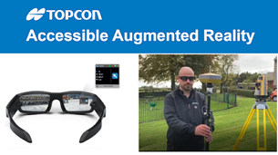
Organised by FIG Commission 6 - Engineering Surveys
Important data for the engineering surveyor is quite often hidden or has not even been materialized, yet. Using a tablet or innovative equipment like goggles or glasses affixed with sensors and a camera, an engineering surveyor can superimpose a computer-generated image, spatially located, over a real scene and add or take away elements from what is currently being seen.
Many very interesting examples of Augmented Reality (AR) applications for cadastre and land management can be found on the internet. However, AR can also be of great benefit in other areas, for example during a construction process. The workshop, hence, focuses on the construction world and the benefits for the engineering surveyor by using this innovative tool.
In order to bring the field of AR closer to engineering surveyors, FIG commission “Engineering Surveys” has invited two well known developers of new solutions - Topcon and Trimble - to help us to understand how much we can profit from this new technology. In this 1.5 hour workshop, first Topcon and then Trimble, are going to share with us the solutions that both enterprises have developed for being applied in the construction world. There will be a period for questions and answers after each presentation, during that Adam Box and Tor-Erik Djupos will, for sure, make us want to include AR in our daily work.
|
14:00-14:10 CET |
Welcome by Maria Henriques, chair of FIG commission 6 |
|
14:10-14:40 CET |
Adam Box and Bruno Fileno, Topcon Topcon is increasingly aware of the convergence of previously unconnected industry sectors. From the impact of cloud technologies to the adoption of 3D gaming engines, the process of capturing and visualising surveying data has never been in such a position of rapid change. One area where Topcon sees significant benefits is with Augmented Reality. Augmented Reality is a rapidly growing method of representing 3D data within the job site environment. During this session we will look at the concept, the benefits it brings and showcase some existing real world solutions. |
|
14:40-15:10 CET |
Tor-Erik Djupos (TED), Trimble Trimble SiteVision is a high accuracy outdoor augmented reality system that enables users to interact with their spatial data in the context of the real world. It can be used in the field to visualize complex construction, road, rail and site designs with accuracy, and measure points, grades, areas, and cut/fill values using GNSS, Electronic Distance Measurement and Augmented Reality technology, as users explore the project site. From bulk earthworks to finished final grade surfaces, stakeholders can communicate and problem-solve in real time. In this presentation we will present the Trimble SiteVision system, workflows, and various use-cases. |
|
15:10-15:25 CET |
Tor-Erik Djupos, Adam Box,
Corinna Harmening
and Maria Henriques |
|
15:25-15:30 CET |
Closing by Corinna Harmening, vice-chair of FIG commission 6 |
 |
 |
Organised by FIG Commission 8 - Spatial planning and development
Land consolidation is considered useful to optimize the allocation of land rights and its land use. To ensure legal certainty for involved stakeholders and ease implementation it is recommended to have dedicated software available that incorporates both spatial and administrative data. However, no off-the-shelf software is available, which might be a barrier for countries aiming to introduce land consolidation. A generic tool could prevent countries from re-inventing the wheel and it will reduce costs for developing or updating customized software.
This workshop provides ample possibilities to discuss the concept of a generic tool for land consolidation. Drawing on generic functionality, this tool can be configured to meet the needs of local contexts regarding tenure system, legislation, and process / procedures.
The programme of this workshop consists of two parts:
We cordially invite you to join this interactive workshop and get a preview of the work done already and discuss the way forward. Your engagement is highly valued.
Organised by FIG Commission 2 - Professional Education
This workshop aims to provide examples of good practice in responding to the constraints of COVID-19 and the rapid move to online and remote education, and discuss these. This will form a basis for workshopping what blended learning will look like for surveying education.
During 2020 all teaching and training institutions had to adapt very quickly so they could respond to the need for remote learning. During this transformation to online learning we saw may very innovative and inspiring approaches to online learning. However, we also found that online learning has very definite disadvantages. Some students really cannot cope well with online learning, and some learning activities need to be face-to-face. These experiences allow us to reflect on the good and bad aspects on transforming our education online. It is now generally accepted that online learning will be part of the future approaches to education, and that the challenge will be to find the best “blend” of online and face-to-face learning.
In this session we have examples of good practices in online education and the most innovative ways learning and teaching to online, and results of a student questionnaire on learning strategies and preferences. There will also be insights into how face-to-face learning can benefit from online content, and how online content can be blended with face-to-face activities. Using break out groups and a World Café approach we also aim to hear from participants about these innovative approaches and how they help us to develop an appropriate “blend” of online and face-to-face learning going forward. This session will help inform the final Commission 2 report on Blended Learning for Surveyors.
|
12:30-14:00 CET |
Blended Learning: lessons from our responses to
COVID-19
|
Awareness and benefits of e-Volunteering has gained significant importance in the current status of the world. After helping to run the SSSI Firewater Event, members of the FIG Volunteer Community Surveyor Program (VCSP) team seek to share knowledge on the benefits of e-Volunteering to not only communities in need but also to surveyors doing the mapping. The VCSP team, in collaboration with Working Group 3.6 “Geospatial Next”, look forward to providing you stories from experts in this field, a short training, some hands-on experience, then finally lay down the foundation for an e-Volunteering event starting at the end of the workshop and running over the following 24 hours.
Audience:
We encourage seasoned surveyors, young surveyors, educators, surveyors of all ages interested in the VCSP, surveyors who would like to participate and play key responsibilities in VGI projects, online mapping projects for humanitarian and environmental groups with limited financial and data accessibility capacity, NGO representatives requiring geodata, Open Street Map (OSM) beginners, OSM wannabe validators and those curious to learn more about e-Volunteering to attend!
Why attend?
Find out about how we can leverage our globally connected world to help humanitarian causes in an accessible, fun way for individuals and communities. Come along to learn about the ways in which you can upskill at the same time as helping a community in need with a real-time mapping exercise. Feel the sense of community that an engaging and enjoyable VCSP e-Volunteering event can instil.
Brief description:
e-Volunteering allows people from all over the world to come together, using their computers and internet connections, to converge in humanitarian surveying digitally. This workshop, brought to you by the VCSP and Geospatial Next (WG 3.6), will present to you lessons from previous e-Volunteering events, and will discuss the potential for e-Volunteering to bring surveyors into the realm of high-value, high-impact change projects. Attendees will also have the chance to use an online mapping tool for themselves before embarking on a 24-hour e-Volunteering event together with other attendees.
Be prepared
Results from the workshop
|
10.30-10.40 |
Brief intro: The Vision of the VCSP and WG3.6 and how
e-Volunteering can help make it happen |
|
10.40-10.45 |
Interactive session (Sli.do) |
| 10.45-10.55 |
The story behind the project and an introduction to
how to map on OSM |
| 10.55-11.00 |
Interactive session |
| 11.00-11.25 |
Tutorial - OpenStreetMap and the Humanitarian
Openstreetmap Team Tasking Platform |
| 11.25-11.30 |
Interactive session |
| 11.30-12.00 |
Tutorial - OpenStreetMap and the Humanitarian
Openstreetmap Team Tasking Platform Continued - Breakout Session
for Validators |
| For the next 23 hours |
24hr Map-a-thon commences! Join the community on Slack and continue mapping! |
 #FIG2021 |